


2020 Ames Earth Science Publications
December 2020
| Airborne Radiometry for Calibration, Validation, and Research in Oceanic, Coastal, and Inland Waters Guild LS, Kudela RM, Hooker SB, Palacios SL and Houskeeper HF (2020) Airborne Radiometry for Calibration, Validation, and Research in Oceanic, Coastal, and Inland Waters. Front. Environ. Sci. 8:585529. doi: 10.3389/fenvs.2020.585529 |
| Biophysical impacts of Earth greening largely controlled by aerodynamic resistance Chen, C., Li, D., Li, Y., Piao, S., Wang, X., Huang, M., … R.R. Nemani, Myneni, R. B. (2020). Biophysical impacts of Earth greening largely controlled by aerodynamic resistance. Science Advances, 6(47), eabb1981. DOI: 10.1126/sciadv.abb1981 |
| Carbon dioxide emissions during the 2018 Kilauea volcano eruption estimated using OCO‐2 satellite retrievals Johnson, Matthew S., F.M. Schwandner, C.S. Potter, H.M. Nguyen, E. Bell, R.R. Nelson, S. Philip, and C.W. O’Dell. “Carbon dioxide emissions during the 2018 Kilauea volcano eruption estimated using OCO‐2 satellite retrievals.” Geophysical Research Letters: e2020GL090507. DOI: 10.1029/2020GL090507 |
| Changes in Vegetation Cover of Yukon River Drainages in Interior Alaska: Estimated from MODIS Greenness Trends, 2000 to 2018 Potter, C. (2020). Changes in Vegetation Cover of Yukon River Drainages in Interior Alaska: Estimated from MODIS Greenness Trends, 2000 to 2018. Northwest Science, 94(2). |
November 2020
| The Observed Water Vapor Budget in an Atmospheric River over the Northeast Pacific Norris, J. R., F. M. Ralph, R. Demirdjian, F. Cannon, B. Blomquist, C. W. Fairall, J. R. Spackman, S. Tanelli, D. E. Waliser, 2020: The Observed Water Vapor Budget in an Atmospheric River over the Northeast Pacific. J. Hydrometeor., 21, 2655–2673. |
| Developing a Spacecraft Air Quality Index for Future Missions Meyer, M.E. and Sorek-Hamer, M., New Space Journal, DOI: 10.1089/space.2020.0018 |
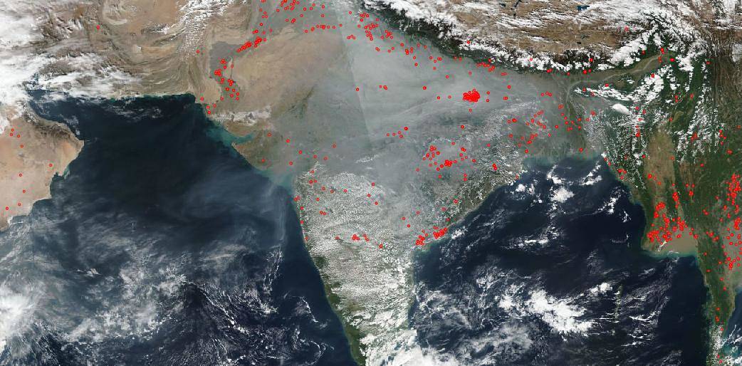
Smoke and haze continues to hang over most of India in this Suomi NPP satellite image from Dec. 10, 2019.
October 2020
| Daytime aerosol optical depth above low-level clouds is similar to that in adjacent clear skies at the same heights: airborne observation above the southeast Atlantic Shinozuka, Y., Kacenelenbogen, M. S., Burton, S. P., Howell, S. G., Zuidema, P., Ferrare, R. A., LeBlanc, S. E., Pistone, K., Broccardo, S., Redemann, J., Schmidt, K. S., Cochrane, S. P., Fenn, M., Freitag, S., Dobracki, A., Segal-Rosenheimer, M., and Flynn, C. J.: Daytime aerosol optical depth above low-level clouds is similar to that in adjacent clear skies at the same heights: airborne observation above the southeast Atlantic, Atmos. Chem. Phys., 20, 11275–11285, https://doi.org/10.5194/acp-20-11275-2020, 2020. |
| Modeling the smoky troposphere of the southeast Atlantic: a comparison to ORACLES airborne observations from September of 2016 Shinozuka, Y., Saide, P. E., Ferrada, G. A., Burton, S. P., Ferrare, R., Doherty, S. J., Gordon, H., Longo, K., Mallet, M., Feng, Y., Wang, Q., Cheng, Y., Dobracki, A., Freitag, S., Howell, S. G., LeBlanc, S., Flynn, C., Segal-Rosenhaimer, M., Pistone, K., Podolske, J. R., Stith, E. J., Bennett, J. R., Carmichael, G. R., da Silva, A., Govindaraju, R., Leung, R., Zhang, Y., Pfister, L., Ryoo, J.-M., Redemann, J., Wood, R., and Zuidema, P.: Modeling the smoky troposphere of the southeast Atlantic: a comparison to ORACLES airborne observations from September of 2016, Atmos. Chem. Phys., 20, 11491–11526, https://doi.org/10.5194/acp-20-11491-2020, 2020. |
September 2020
| Gradient boosting machine learning to improve satellite-derived column water vapor measurement error Just, A. C., Liu, Y., Sorek-Hamer, M., Rush, J., Dorman, M., Chatfield, R., Wang, Y., Lyapustin, A., and Kloog, I.: Gradient boosting machine learning to improve satellite-derived column water vapor measurement error, Atmos. Meas. Tech., 13, 4669–4681, https://doi.org/10.5194/amt-13-4669-2020, 2020. |
| Review: Strategies for using satellite-based products in modeling PM2.5 and short-term pollution episodes Sorek-Hamer, M., Chatfield, R., Liu, Y., Review: Strategies for using satellite-based products in modeling PM2.5 and short-term pollution episodes, Environment International 144, Nov 2020, 106057. |
| NASA NeMO-Net’s Convolutional Neural Network: Mapping Marine Habitats with Spectrally Heterogeneous Remote Sensing Imagery A. S. Li, V. Chirayath, M. Segal-Rozenhaimer, J. L. Torres-Pérez and J. van den Bergh, NASA NeMO-Net’s Convolutional Neural Network: Mapping Marine Habitats with Spectrally Heterogeneous Remote Sensing Imagery, IEEE Journal of Selected Topics in Applied Earth Observations and Remote Sensing, 13, 5115-5133 (2020). DOI: 10.1109/JSTARS.2020.3018719. |
| Methane emissions from natural gas vehicles in China D. Pan, L. Tao, K. Sun, L. Golston, D., T. Zhu, Y. Qin, Y. Zhang, D. Mauzerall, M. Zondlo. Methane emissions from natural gas vehicles in China. Nature Communications 11, 4588 (2020). DOI: 10.1038/s41467-020-18141-0 |
| The Aerosol Characterization from Polarimeter and Lidar (ACEPOL) airborne field campaign Knobelspiesse, K., …., Tan, Q., et al..: The Aerosol Characterization from Polarimeter and Lidar (ACEPOL) airborne field campaign, Earth Syst. Sci. Data, 12, 2183–2208, (2020). DOI: 10.5194/essd-12-2183-2020, 2020. |
August 2020
| Two Scientific Communities Striving for a Common Cause: innovations in carbon cycle science Whelan, M.E.; Anderegg, L.D.L.; Badgley, G.; Campbell, J.E.; Commane, R.; Frankenberg, C.; Hilton, T.W.; Kuai, L.; Parazoo, N.; Shiga, Y., Wang, Y.; J. Worden (2020): Two Scientific Communities Striving for a Common Cause: innovations in carbon cycle science. Bull. Amer. Meteor. Soc. (2020) |
| Vertical distribution of smoke aerosols over upper Indo-Gangetic Plain Vinjamuri, K. S., Mhawish, A., Banerjee, T., Sorek-Hamer, M., Broday, D. M., Mall, R. K., & Latif, M. T. (2020). Vertical distribution of smoke aerosols over upper Indo-Gangetic Plain. Environmental Pollution, 257, 113377. |
| Ensemble-Guided Tropical Cyclone Track Forecasting for Optimal Satellite Remote Sensing V. Ravindra, S. Nag and A. Li, “Ensemble-Guided Tropical Cyclone Track Forecasting for Optimal Satellite Remote Sensing,” in IEEE Transactions on Geoscience and Remote Sensing, 2020 (Early Access), 16 p. doi: 10.1109/TGRS.2020.3010821. |
| Phenology of primary producers In: State of the Climate in 2019 (chapter 2: Global Climate) Hemming, D.L., Garforth, J., Park, T., Richardson, A.D., Rutishäuser, A.D., Sparks, T.H., Thackeray, S.j., Myneni, R., (2020). Phenology of primary producers. In: Dunn, R.J.H., Stanitski, D.M., Gobron, N., and K.M. Willett, Eds., “State of the Climate in 2019 – Global Climate”. Special Supplement to Bulletin of the American Meteorological Society, 101, pp.S95-S98. |
July 2020
| Changes in Growing Season Phenology Following Wildfires in Alaska Potter, C. Changes in Growing Season Phenology Following Wildfires in Alaska. Remote Sens Earth Syst Sci (2020). |
| Spatial Particulate Fields During High Winds in the Imperial Valley, California Freedman F.R., English P., Wagner J., Liu Y., Tong D. Q., VenkatramA., Al-Hamdan M. Z., Sorek-Hamer M., Chatfield R., Rivera A: Spatial Particulate Fields During High Winds in the Imperial Valley, California. Atmosphere 11(1), 88. DOI:10.3390/atmos11010088 |
| Atom: In Situ Measurements of Airflow and Aerosols from Multiple Airborne Campaigns Spanu, A., M. Dollner , J. Gasteiger , T.P. Bui, and B. Weinzierl . (2020). ATom : In Situ Measurements of Airflow and Aerosols from Multiple Airborne Campaigns. ORNL DAAC, Oak Ridge, Tennessee, USA. DOI: 10.3334/ORNLDAAC/1784 |
| Impact of convectively‐detrained ice crystals on the humidity of the tropical tropopause layer in boreal winter Ueyama, R., E. Jensen, L. Pfister, M. Krämer, A. Afchine, and M. Schoeberl (2020): Impact of convectively-detrained ice crystals on the humidity of the tropical tropopause layer in boreal winter, JGR Atmospheres. DOI: 10.1029/2020JD032894 |
| IrrMapper: A Machine Learning Approach for High Resolution Mapping of Irrigated Agriculture Across the Western U.S. Ketchum, D., Jencso, K., Maneta, M., Melton, F., Jones, M.O., and J. Huntington, 2020. IrrMapper: A Machine Learning Approach for High Resolution Mapping of Irrigated Agriculture Across the Western U.S. Remote Sens. 2020, 12(14), 2328; https://doi.org/10.3390/rs12142328 |
| Methane emission from high latitude lakes: methane centric lake classification and satellite driven annual cycle of emissions Matthews, E., Johnson, M.S., Genovese, V. et al. Methane emission from high latitude lakes: methane-centric lake classification and satellite-driven annual cycle of emissions. Sci Rep 10, 12465 (2020). DOI: 10.1038/s41598-020-68246-1 |
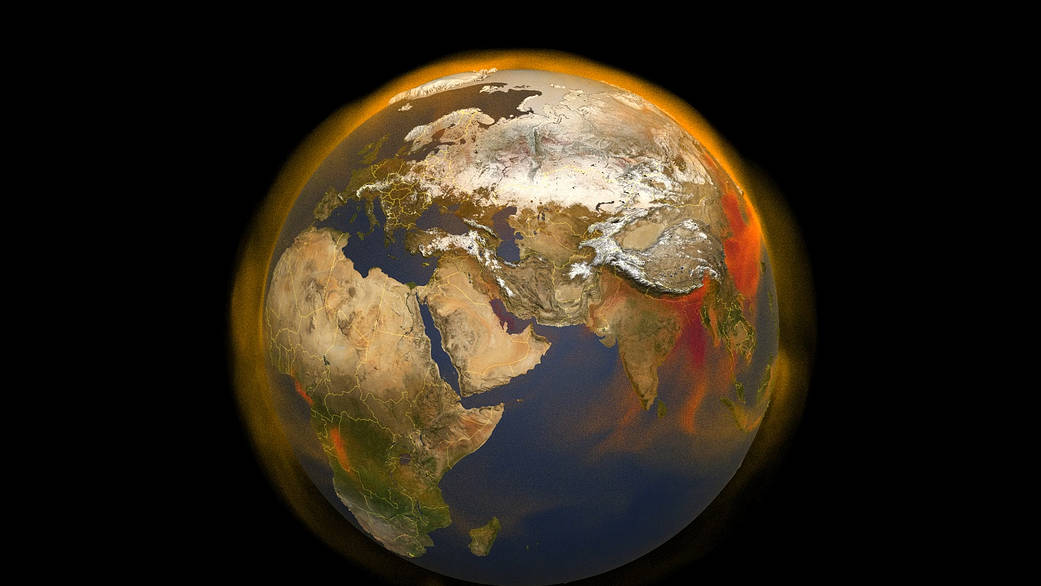
NASA’s new three-dimensional portrait of methane concentrations shows the world’s second largest contributor to greenhouse warming.
June 2020
| The ERATOSTHENES Centre of Excellence (ECoE) as a Digital Innovation Hub for Earth Observation Hadjimitsis, D., G. Schreier, H. Kontoes, A. Ansmann, G. Komodromos, K. Themistocleous, K. Neocleous, S. Michaelides, R. Mamouri, I.Papoutsis, J. Bühl, E. Schwarz, S. Tziortzis, C. Danezis, A. Nisantzi, C. Mettas, C. Papoutsa, G. Melillos, M. Tzouvaras, E. Evagorou, A. Agapiou, A. Christofe, M. Prodromou, V. Lysandrou, T. Polydorou, P. Kyriakidis, N. Kyriakides, E. Akylas, V. Ambrosia, M. Maranesi, P. Zeil, L. Halounova, D. Barok, 2020. The ERATOSTHENES Centre of Excellence (ECoE) as a Digital Innovation Hub for Earth Observation, Proc. SPIE 11418, Detection and Sensing of Mines, Explosive Objects, and Obscured Targets XXV, 114180F (24 April 2020). DOI:10.1117/12.2567070 |
| Estimation of high-resolution PM2.5 over Indo-Gangetic Plain by fusion of satellite data, meteorology and land use variables Mhawish, A., Banerjee, T., Sorek Hamer, M., Bilal, M., Lyapustin , R.B. Chatfield, A., Broday , D.: Estimation of high resolution PM2.5 over Indo Gangetic Plain by fusion of satellite data, meteorology and land use variables. Environ. Sci. Technol. 2020. |
| Mapping 30 Years of Change in the Marshlands of Breton Sound Basin (Southeastern Louisiana, U.S.A.): Coastal Land Area and Vegetation Green Cover Potter, C. and Amer, R., 2020. Mapping 30 years of change in the marshlands of Breton Sound basin (southeastern Louisiana, U.S.A.): Coastal land area and vegetation green cover. Journal of Coastal Research, 36(3), 437–450. Coconut Creek (Florida), ISSN 0749-0208. |
| Variability of ammonia and methane emissions from animal feeding operations in northeastern Colorado Golston, L.M., D. Pan, K. Sun, L. Tao, M.A. Zondlo , S.J. Eilerman , J. Peischl , J.A. Neuman, and C. Floerchinger : Variability of ammonia and methane emissions from animal feeding operations in northeastern Colorado. Environ. Sci. Technol. 2020. |
| US National Maps Attributing Forest Change: 1986–2010 Schleeweis, K.G.; Moisen, G.G.; Schroeder, T.A.; Toney, C.; Freeman, E.A.; Goward, S.N.; Huang, C.; Dungan, J.L. (2020) US National Maps Attributing Forest Change: 1986–2010. Forests, 11, 653. |
May 2020
| An introduction to the Geostationary-NASA Earth Exchange (GeoNEX) Products: 1. Top-of-atmosphere reflectance and brightness temperature Wang, W., Shuang Li, Hashimoto, H., Takenaka, H., Higuchi, A., Kalluri, S., & Nemani, R. R. (2020). Remote Sensing, 12, 1267. |
| Changes in Vegetation Phenology and Productivity in Alaska Over the Past Two Decades C. Potter & O. Alexander (2020). Remote Sens. 2020, 12(10), 1546 |
| Data Mining for Weather Impacts on Crop Yield Big Data for Food, Energy and Water Konduri, V. S., Thomas J. Vandal, Sangram Ganguly and Auroop R. Ganguly (2020). Data Mining for Weather Impacts on Crop Yield. Frontiers in Sustainable Food Systems, 4(May), 1–11. doi://10.3389/fsufs.2020.00052 |
| Changes in Vegetation Phenology and Productivity in Alaska Over the Past Two Decades Potter, C. & Alexander, O. (2020), Changes in Vegetation Phenology and Productivity in Alaska Over the Past Two Decades: Remote Sens., 12(10), 1546. |
| The California Baseline Ozone Transport Study (CABOTS) Faloona, I. C., S. Chiao, A. J. Eiserloh, R. J. Alvarez II, G. Kirgis, A. O. Langford, C. J. Senff, D. Caputi, A. Hu, L. T. Iraci, E. L. Yates, J. E. Marrero, J.-M. Ryoo, S. Conley, S.Tanrikulu, J. Xu, and T. Kuwayama (2020). Bull. Amer. Meteor. Soc. 101, E427–E445. |
April 2020
| DeepEmSat: Deep Emulation for Satellite Data Mining Duffy, K., Vandal, T., Li, S., Ganguly, S., Nemani, R., & Ganguly, A. R. (2019). DeepEmSat: Deep Emulation for Satellite Data Mining. Frontiers in Big Data, 2 (December), 1–8. DOI:10.3389/fdata.2019.00042 |
| Deep Neural Network Cloud-Type Classification (DeepCTC) Model and Its Application in Evaluating PERSIANN-CCS Gorooh, V. A., Kalia, S., Nguyen, P., Hsu, K., Sorooshian, S., Ganguly, S., & Nemani, R. R. (2020). Deep Neural Network Cloud-Type Classification (DeepCTC) model and its application in evaluating PERSIANN-CCS. Remote Sensing, 12(2). doi://10.3390/rs12020316 |
| Climate Explorer: Improved Access to Local Climate Projections Lipschultz F, Herring DD, Ray AJ, Alder JR, Dahlman L, DeGaetano AT, Fox JF, Gardiner EP, Herring J, Hicks J, Melton F, Morefield, P, and Sweet, W. Climate Explorer: Improved Access to Local Climate Projections. Bulletin of the American Meteorological Society. 2020 Mar;101(3): E265-73 |
| Satellite mapping of PM2.5 episodes in the wintertime San Joaquin Valley: a “static” model using column water vapor Robert B. Chatfield, Meytar Sorek-Hamer, Robert F. Esswein, and Alexei Lyapustin, Atmos. Chem. Phys., 20, 4379–4397, 2020. |
| Ozone production in the Soberanes smoke haze: implications for air quality in the San Joaquin Valley during the California Baseline Ozone Transport Study Andrew O. Langford, Raul J. Alvarez II, J. Brioude, Dani Caputi, Stephen A. Conley, S. Evan, Ian C. Faloona, Laura T. Iraci, Guillaume Kirgis, Josette E. Marrero, Ju‐Mee Ryoo, Christoph J. Senff & Emma L. Yates, Journal of Geophysical Research Atmospheres, 2020. |
March 2020
| Snowmelt timing impacts on growing season phenology in the northern range of Yellowstone National Park estimated from MODIS satellite data Potter, C. Snowmelt timing impacts on growing season phenology in the northern range of Yellowstone National Park estimated from MODIS satellite data. Landscape Ecol 35, 373–388 (2020). |
| First Provisional Land Surface Reflectance Product from Geostationary Satellite Himawari-8 AHI Li, S.; Wang, W.; Hashimoto, H.; Xiong, J.; Vandal, T.; Yao, J.; Qian, L.; Ichii, K.; Lyapustin, A.; Wang, Y.; Nemani, R. First Provisional Land Surface Reflectance Product from Geostationary Satellite Himawari-8 AHI. Remote Sens. 2019, 11, 2990. |
| The California Baseline Ozone Transport Study (CABOTS) Faloona, I.C., S. Chiao, A.J. Eiserloh, R.J. Alvarez, G. Kirgis, A.O. Langford, C.J. Senff, D. Caputi, A. Hu, L.T. Iraci, E.L. Yates, J.E. Marrero, J. Ryoo, S. Conley, S. Tanrikulu, J. Xu, and T. Kuwayama: The California Baseline Ozone Transport Study (CABOTS). Bulletin American Meteorological Society, 2020. |
| Attribution of Chemistry-Climate Model Initiative (CCMI) ozone radiative flux bias from satellites Kuai, L., Bowman, K. W., Miyazaki, K., Deushi, M., Revell, L., Rozanov, E., Paulot, F., Strode, S., Conley, A., Lamarque, J.-F., Jöckel, P., Plummer, D. A., Oman, L. D., Worden, H., Kulawik, S., Paynter, D., Stenke, A., and Kunze, M.: Attribution of ChemistryClimate Model Initiative (CCMI) ozone radiative flux bias from satellites, Atmos. Chem. Phys., 20, 281–301 (2020). |
| Species- and elevation-dependent productivity changes in East Asian temperate forests Afzali Gorooh, V., Kalia, S., Nguyen, P., Hsu, K.L., Sorooshian, S., Ganguly, S. and Nemani, R.R., 2020. Deep Neural Network Cloud-Type Classification (DeepCTC) Model and Its Application in Evaluating PERSIANN-CCS. Remote Sensing, 12(2), p.316 (19p.) (2020). |
| Intercomparison of biomass burning aerosol optical properties from in-situ and remote-sensing instruments in ORACLES-2016 K. Pistone, J. Redemann, S. Doherty, P. Zuidema, S. Burton, B. Cairns, S. Cochrane, R. Ferrare, C. Flynn, S. Freitag, S. G. Howell, M. Kacenelenbogen, S. LeBlanc, X. Liu, K.S. Schmidt, A.J. Sedlacek III, M. Segal-Rozenhaimer, Y. Shinozuka, S. Stamnes, B. van Diedenhoven, G. Van Harten, and F. Xu (2019). “Intercomparison of biomass burning aerosol optical properties from in-situ and remote-sensing instruments in ORACLES-2016,” Atmos. Chem. Phys., 19, 9181-9208, doi:10.5194/acp-19-9181-2019. |
| Radiative Heating of an Ice-free Arctic Ocean K. Pistone, I. Eisenman, V. Ramanathan (2019). “Radiative Heating of an Ice-free Arctic Ocean,” Geophysical Research Letters, 46. doi:10.1029/2019GL082914 |
| The effect of an upwind non-attainment area on California’s Sierra Nevada mountains Yates, E.L, Iraci, L.T, Tarnay, L.W, Burley, J.D. Parworth, C. & Ryoo, J.M. The effect of an upwind non-attainment area on California’s Sierra Nevada mountains. Atmospheric Environment. |
February 2020
| Terrain trapped airflows and precipitation variability during an atmospheric river event Iraci, F.M. Ralph, A. Martin, R.M. Dole, J.E. Marrero, E.L. Yates, T.P. Bui, J.M. Dean-Day, and C.S. Chang: Terrain Trapped Airflows and Precipitation Variability during an Atmospheric River Event. J. Hydrometeor. 2020. |
| Cloud detection algorithm for multi-modal satellite imagery using convolutional neural-networks (CNN) identification for a tropical area. Segal-Rozenhaimer, M., Li, A., Das, K., and Chirayath, V. (2020) Cloud detection algorithm for multi-modal satellite imagery using convolutional neural-networks (CNN). Remote Sensing of Environment. 237: 111446 |
| Above-cloud aerosol optical depth from airborne observations in the southeast Atlantic LeBlanc, S. E., Redemann, J., Flynn, C., Pistone, K., Kacenelenbogen, M., SegalRosenheimer, M., Shinozuka, Y., Dunagan, S., Dahlgren, R. P., Meyer, K., Podolske, J., Howell, S. G., Freitag, S., Small-Griswold, J., Holben, B., Diamond, M., Wood, R., Formenti, P., Piketh, S., Maggs-Kölling, G., Gerber, M., and Namwoonde, A. (2020) Above-cloud aerosol optical depth from airborne observations in the southeast Atlantic, Atmos. Chem. Phys., 20, 1565–1590. |
| Spatiotemporal Characteristics of the Association between AOD and PM over the California Central Valley Sorek-Hamer, M., Franklin, M., Chau, K., Garay, M., Kalashnikova, O. (2020). Spatiotemporal Characteristics of the Association between AOD and PM over the California Central Valley. Remote Sensing 2020, 12(4), 685. DOI: 10.3390/rs12040685 |
| Simulated polarization as a signature of aerosol type Hamill, P., Piedra, P., Giordano, M. (2020): Simulated Polarization as a Signature of Aerosol Type. Atmospheric Environment, 224, 2020, 117348. Published in Atmospheric Environment, 224, 2020, 117348 |

A natural-color image of Hurricane Zeta was acquired in the late morning on October 28, 2020, by the Moderate Resolution Imaging Spectroradiometer (MODIS) on NASA’s Terra satellite. Cameras mounted on the International Space Station captured video footage of the storm just before 1 p.m. that day.
NASA’s Earth Observatory
January 2020
| Snowmelt timing impacts on growing season phenology in the northern range of Yellowstone National Park estimated from MODIS satellite data Potter, C., Snowmelt timing impacts on growing season phenology in the northern range of Yellowstone National Park estimated from MODIS satellite data. Landscape Ecology (2020) |
| Air pollution inputs to the Mojave Desert by fusing surface mobile and airborne in situ and airborne and satellite remote sensing: A case study of interbasin transport with numerical model validation Leifer, I; Melton, C.; Chatfield, R. B.; Cuic, X; Fischerd, M.L.; Fladeland, M.; Gore, W.; Hlavka, D.L.; Iraci, L.T.; Marrero, J.; Ryoo, JM.; Tanaka, T; Yates, E.; and Yorks, J., Atmospheric Environment, (2020) |
| Characteristics, drivers and feedbacks of global greening Piao, S., Wang, X., Park, T., Chen, C., Lian, X., He, Y., Bjerke, J.W., Chen, A., Ciais, P., Tømmervik, H., Nemani, R.R., Myneni, R.B., Characteristics, drivers and feedbacks of global greening. Nature Reviews: Earth & Environment 1, 14–27 (2020) |
| Validation of OCO-2 error analysis using simulated retrievals Kulawik, S. S., O’Dell, C., Nelson, R. R., and Taylor, T. E.: Validation of OCO-2 error analysis using simulated retrievals, Atmos. Meas. Tech., 12, 5317–5334. 2019. |
| Above-cloud aerosol radiative effects based on ORACLES 2016 and ORACLES 2017 aircraft experiments Cochrane, S. P., Schmidt, K. S., Chen, H., Pilewskie, P., Kittelman, S., Redemann, J., LeBlanc, S., Pistone, K., Kacenelenbogen, M., Segal Rozenhaimer, M., Shinozuka, Y., Flynn, C., Platnick, S., Meyer, K., Ferrare, R., Burton, S., Hostetler, C., Howell, S., Freitag, S., Dobracki, A., and Doherty, S.: Above-cloud aerosol radiative effects based on ORACLES 2016 and ORACLES 2017 aircraft experiments, Atmos. Meas. Tech., 12, 6505– 6528. 2019. |