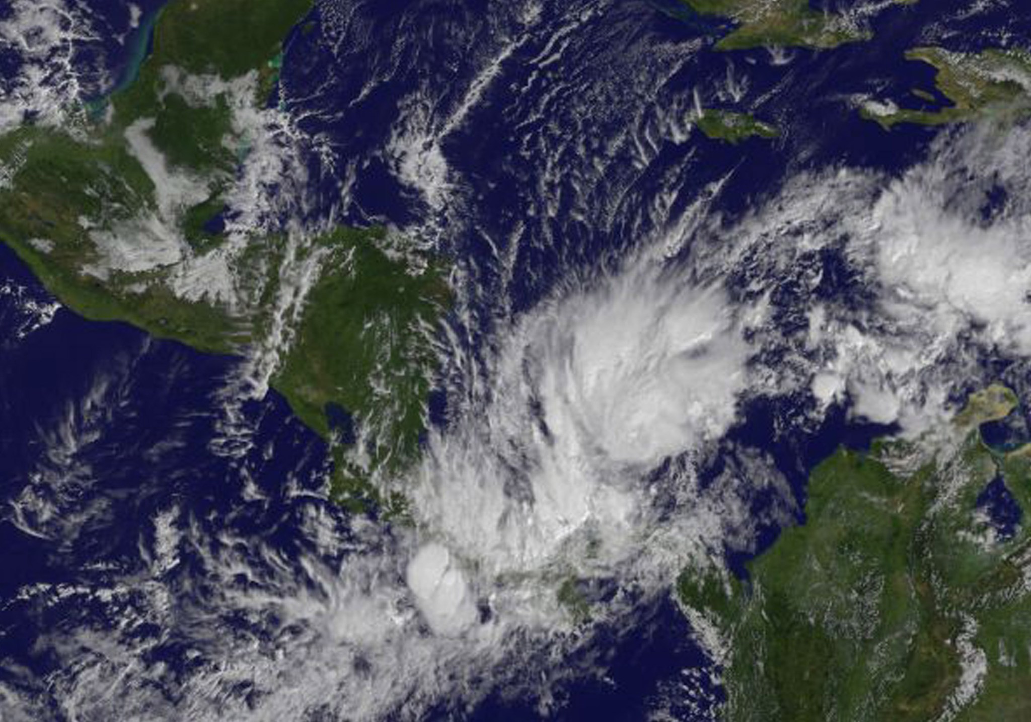
Nov. 30, 2016 – NASA Animation Shows Hurricane Otto Over 5 Days
Credits: NASA/NOAA GOES Project, Dennis Chesters
Nov. 26, 2016 – NASA Calculates Record-Setting Hurricane Otto’s Rainfall in Nicaragua and Costa Rica
NASA calculated that Otto brought heavy rainfall and large rainfall totals to Nicaragua and Costa Rica. Otto is the southernmost land falling hurricane in Central America on record. By Nov. 26, Otto weakened to a tropical storm and moved into the Eastern Pacific Ocean.
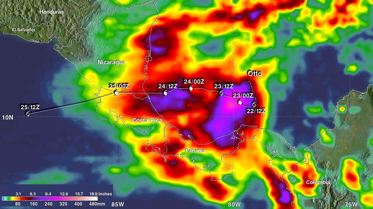
Hurricane Otto hit the southern coast of Nicaragua on November 24, 2016 at about 1 p.m. EST (1800 UTC). Otto had winds of about 95 knots (109 mph). The hurricane crossed into Nicaragua just north of the town of San Juan de Nicaragua that is located at 10.9 degrees North latitude. Otto dropped flooding rainfall as is weakened and moved through northwestern Coast Rica. Otto was still a well organized tropical storm when it moved into the Eastern Pacific early on November 25, 2016. Otto’s maximum sustained winds had only dropped to about 61 knots (70 mph) as it moved off the coast of Costa Rica.
Otto caused the deaths of at least three people in Panama a couple days before it hit Nicaragua. Lives may have been saved in Nicaragua and Costa Rica as thousands of people were evacuated ahead of Otto’s arrival but at least four people were still reported killed in Costa Rica.
NASA’s IMERG, or Integrated Multi-satellitE Retrievals for the Global Precipitation Measuremnent mission or GPM core satellite were used to estimate the total amount of rain that Otto dropped over Central America. The analysis, made at NASA’s Goddard Space Flight Center in Greenbelt, Maryland showed estimated rainfall totals during the period from November 21-25, 2016. This period included formation in the southwestern Caribbean and Otto’s path over Nicaragua and Costa Rica into the Eastern Pacific. IMERG estimates show that Otto dropped the greatest amount of rain while it was forming and circling in the Caribbean. IMERG data indicates that over 365 mm (14.4 inches) in the Caribbean Sea north of Panama. Otto’s heaviest IMERG rainfall over land were along Panama’s and Nicaragua’s Caribbean coasts where estimates were greater than 228 mm (9 inches).
Credits: NASA/JAXA, Hal Pierce
At 10 a.m. (1500 UTC) on Saturday, Nov. 26 the center of Tropical Storm Otto was about 460 miles (740 km) southwest of San Salvador, El Salvador, near 9.0 degrees north latitiude and 94.0 degrees west longitude. The National Hurricane Center (NHC) said Otto moving toward the west near 16 mph (26 kph), and this motion is expected to continue during the next day or so. Maximum sustained winds were near 45 mph (75 kph) with higher gusts. Weakening is forecast during the next 48 hours.
NHC forecaster Lixion Avila noted in the NHC discussion “The cloud pattern has deteriorated significantly during the past several hours and it appears that the system is degenerating in a trough of low pressure. It is very difficult to ascertain if there is a circulation by inspecting the conventional satellite imagery or even earlier microwave data.”
Otto is expected to weaken to a post-tropical remnant low pressure area by Nov. 30.
Hal Pierce/Rob Gutro
NASA’s Goddard Space Flight Center
Nov. 25, 2016 -NASA Sees Hurricane Otto’s Landfall and Exit from Nicaragua
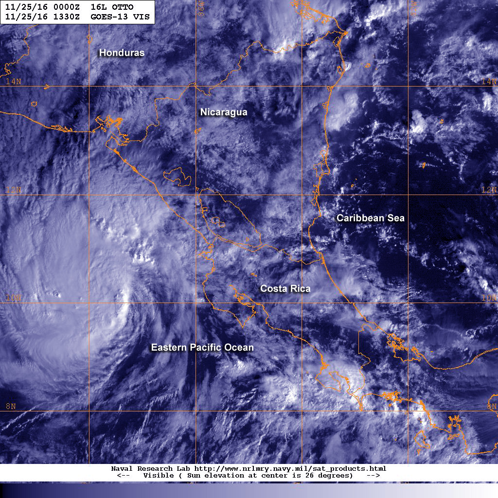
Hurricane Otto made landfall in southern Nicaragua on Thursday, Nov. 24 with maximum sustained winds near 110 mph (175 kph) as a strong Category 2 hurricane on the Saffir-Simpson Hurricane Wind Scale. A NASA animation of NOAA’s GOES satellite imagery captured the movement and landfall of this late-season storm.
At 1 p.m. EST on Nov. 24 the eye of dangerous hurricane Otto made landfall on the southern Nicaraguan coast near the town of San Juan De Nicaragu, which is about 70 miles (110 km) south of Bluefields, Nicaragua.
An animation of visible and infrared imagery from NOAA’s GOES-East satellite over the period of Nov. 22 to Nov. 25 showed Hurricane Otto moving through the southwestern Caribbean Sea and make landfall in southern Nicaragua on Nov. 24. The GOES series of satellites are managed by NOAA, and the NASA/NOAA GOES Project at NASA’s Goddard Space Flight Center in Greenbelt, Maryland uses that data to create images and animations.
On Nov. 25 at 7 a.m. EST (1200 UTC) Otto’s center had exited Nicaragua and moved into the Eastern Pacific Ocean. The National Hurricane Center (NHC) said that all warnings and watches have been discontinued.
Credits: NASA/NOAA GOES Project
The center of Tropical Storm Otto was located near latitude 10.5 North and longitude 87.6 West. That puts the center of Otto about 115 miles (190 km) west-southwest of Santa Elena, Costa Rica. Otto was moving toward the west near 14 mph (22 kph). NHC expects a westward motion on Saturday, Nov. 26. Maximum sustained winds are near 60 mph (95 kph) with higher gusts. Little change in strength is forecast during the next 48 hours.
For updated forecasts visit the NHC website: http://www.nhc.noaa.gov
Rob Gutro
NASA’s Goddard Space Flight Center
Nov. 23, 2016 – NASA Sees Tropical Storm Otto Heading Toward Landfall in Central America
Satellites are keeping track of late-season Tropical Storm Otto as it threatens Central America. NASA-NOAA’s Suomi NPP satellite captured an image of Otto as it was briefly strengthening into a hurricane.
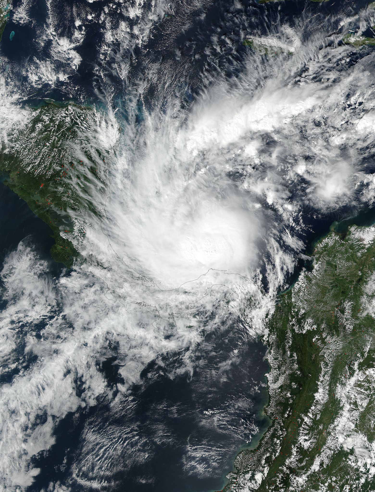
On Nov. 22 at 2:24 p.m. EST (18:24 UTC) the Visible Infrared Imaging Radiometer Suite (VIIRS) instrument aboard the NASA-NOAA Suomi NPP satellite captured a visible image of Otto as it was strengthening into a hurricane in the Caribbean Sea. Although Otto was strengthening into a hurricane the eye was not yet visible in the VIIRS image.
A Hurricane Warning is in effect for Limon Costa Rica to Bluefields, Nicaragua. A Hurricane Watch is in effect from north of Bluefields to Sandy Bay Sirpi, Nicaragua and south of Limon to the Costa Rica/Panama border. In addition, a Tropical Storm Warning is in effect from north of Bluefields to Sandy Bay Sirpi, Nicaragua and San Andres. A Tropical Storm Watch is in effect from west of Colon, Panama to the Costa Rica/Panama border and from Puntarenas, Costa Rica to Puerto Sandino, Nicaragua.
On Nov. 22 at 4 p.m. EST, Tropical Storm Otto strengthened into the seventh hurricane of the Atlantic Ocean Hurricane Season when maximum sustained winds reached 75 mph (120 kph). Otto maintained that strength until Nov. 23 at 7 a.m. EST when it weakened to a tropical storm.
The National Hurricane Center said that “Air Force Reserve reconnaissance mission reported that the eyewall has dissipated, along with a 6 millibar rise in pressure.”
By 10 a.m. EST (1500 UTC), the center of Tropical Storm Otto was located near latitude 11.1 north and longitude 80.7 West. That’s about 175 miles (280 km) east-northeast of Limon, Costa Rica and 220 miles (350 km) east-southeast of Bluefields, Nicaragua. The estimated minimum central pressure is 994 millibars.
Otto was moving toward the west-northwest near 5 mph (7 kph) and NHC said a turn toward the west with an increase in forward speed is expected tonight and Thursday. On the forecast track, the center of Otto will move onshore within the hurricane warning area on Thursday, and reach the Pacific coast of southern Nicaragua or northern Costa Rica early Friday.
Maximum sustained winds remain near 70 mph (110 kph) with higher gusts.
Otto is forecast to become a hurricane again on Thursday, Nov. 24 before weakening over Central America after landfall.
For updated forecasts, visit the NHC website: www.nhc.noaa.gov
Rob Gutro
NASA’s Goddard Space Flight Center
Nov. 22, 2016 – NASA Sees Tropical Storm Otto Develop, Threaten Central America
As Tropical Storm Otto formed in the southwestern Caribbean north of Panama on Nov. 21 the Global Precipitation Measurement mission or GPM core satellite analyzed the strengthening storm.
At 1 p.m. EST (1800 UTC) on Nov. 21, Tropical Depression 16 strengthened into a tropical storm and was named Otto. At that time, maximum sustained winds had increased to near 50 mph (85 kph) with higher gusts. Otto continued to strengthen and the National Hurricane Center expects the storm to reach hurricane strength.
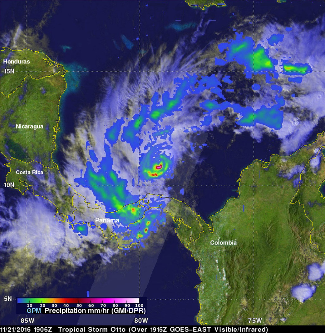
The GPM core observatory satellite had an excellent daytime view of the newly formed tropical storm on Nov. 21 at 2:06 p.m. EST (1906 UTC). Otto had wind speeds estimated at 45 knots (52 mph) at that time. GPM’s Microwave Imager (GMI) and Dual-Frequency Precipitation Radar (DPR) revealed that the newly formed tropical storm had deep convective bursts and fast development of thunderstorms near the center of circulation. Rain was measured by DPR falling at a rate of over 94 mm (3.7 inches) per hour. 3-D measurements of tropical storm Otto’s precipitation were made with GPM’s radar (DPR Ku Band). DPR measured tall convective storms near Otto’s center. Some of these tall storms were found by GPM to stretch to heights above 17 km (10.5 miles).
On Nov. 22 the governments of Nicaragua and Costa Rica have issued a Hurricane Watch from the Costa Rica/Panama border to south of Bluefields, Nicaragua. A Tropical Storm Warning is in effect for Nargana to Colon and a Tropical Storm Watch is in effect for San Andres to the west of Colon to the Costa Rica/Panama border.
At 10 a.m. EST (1500 UTC), the center of Tropical Storm Otto was located near 10.4 degrees north latitude and 79.2 degrees west longitude, about 330 miles (530 km) east-southeast of Bluefields, Nicaragua. The National Hurricane Center (NHC) said that Otto is stationary and a westward drift is expected to continue moving west. On the forecast track, Otto should be approaching the coasts of Nicaragua and Costa Rica on Thursday, Nov. 24. Maximum sustained winds are near 70 mph (110 kph) with higher gusts.
Otto is expected to become a hurricane later today or tonight, with additional strengthening forecast through Thursday. Otto is expected to be a hurricane when it hits the Central American coast near the Nicaragua and Costa Rica border in about three days.
The heavy rainfall rates that GPM observed are a concern for Central America. NHC said that “Outer rain bands from Otto are expected to produce rainfall accumulations of 3 to 6 inches over San Andres and Providencia islands, and the higher terrain of central and western Panama and southern Costa Rica through Wednesday. Total rainfall of 6 to 12 inches, with isolated amounts of 15 to 20 inches, can be expected across northern Costa Rica and southern Nicaragua through Thursday. These rains will likely result in life-threatening flash floods and mud slides.
Otto is expected to weaken over land but could then cross into the Eastern Pacific as a tropical depression.
For updated forecasts on Otto, visit the NHC website: www.nhc.noaa.gov.
Hal Pierce/Rob Gutro
NASA’s Goddard Space Flight Center
Nov. 21, 2016 -Late-Season Tropical Depression Forms in Southern Caribbean Sea
A late-season tropical depression formed in the southwestern Caribbean Sea on Nov. 21 and NOAA’s GOES-East satellite provided a look at the storm. Tropical Depression 16 formed from System 90L, a tropical low pressure area that had been lingering in the Caribbean Sea for days. Tropical Depression 16 formed around 4 a.m. EST on Nov. 21.
Visible imagery from NOAA’s GOES-East satellite at 10:45 a.m. EST (1445 UTC) on Monday, Nov. 21 showed that the depression’s cloud pattern appeared better organized. Satellite imagery showed some banding of thunderstorms over the northern and western portions of the circulation and small bursts of deep convection near or over the estimated center.
NOAA manages the GOES series of satellites and NASA’s GOES Project at the NASA Goddard Space Flight Center in Greenbelt, Maryland uses the data to create images and animations. The image showed that the center of Tropical Depression 16 was about 300 miles from Nicaragua.
At 11 a.m. EST on Nov. 21 there were no coastal watches or warnings in effect. However, the National Hurricane Center (NHC) said that “Interests in Nicaragua, Costa Rica, and the islands of San Andres and Providencia should monitor the progress of this system, since a Tropical Storm Watch may be required later today or tonight.”
At 10 a.m. EST (1500 UTC), the center of Tropical Depression Sixteen was located near 11.5 degrees north latitude and 79.3 degrees west longitude, about 175 miles (285 km) east-southeast of San Andres Island and about 305 miles (495 km) east of Bluefields, Nicaragua. The depression is nearly stationary and NHC expects a west-southwestward to westward drift over the next couple of days.
Maximum sustained winds are near 35 mph (55 km/h) with higher gusts. Some strengthening is forecast during the next 48 hours, and the depression is likely to become a tropical storm later today. The estimated minimum central pressure is 1002 millibars.
NHC noted that rainfall will affect parts of Panama and Costa Rica. “Outer rain bands from the depression are expected to produce rainfall accumulations of 3 to 6 inches across portions of central and western Panama and southeastern Costa Rica through Wednesday, with isolated totals upwards of 10 to 15 inches across the higher terrain. These rains could result in life-threatening flash floods and mud slides. Additional heavy rainfall may move into portions of Costa Rica Wednesday night into Thursday as the system approaches the coast.”
National Hurricane Center forecaster Richard Pasch noted “There is moderate south-southeasterly [vertical wind] shear over the depression, and this should allow for only slow strengthening over the next day or two. In 72 hours or so, some relaxation of the shear is forecast with an upper-level anticyclone developing over the tropical cyclone, and the system is predicted to become a hurricane before landfall.”
For updates, visit: www.nhc.noaa.gov.


