


NARRATOR
It was Bulldog Day, 1957. Homecoming festivities at New Mexico’s Albuquerque High School were well underway. The morning’s parade, a vibrant display of green and white, had been a rousing success, even if Mrs. Hefferan’s students hadn’t won any prizes for their float.
But any disappointment they may have had would soon be forgotten, though not because of the homecoming game. No. Many of Mrs. Hefferan’s students wouldn’t even attend. Not because they didn’t care for the sport. Certainly not. Because something far more significant than a football had just taken flight.
It was Oct. 4, 1957, and the Soviets had launched Sputnik, the world’s first artificial satellite at 1:28 p.m. New Mexico time from what is now the Baikonur Cosmodrome in Kazakhstan.
Mrs. Hefferan received the call just as she returned home from the parade. A frenzied few hours later, back on campus, atop the flat roof of Old Main, Mrs. Hefferan stood amongst two dozen students, homecoming plans cancelled, rapt attention on the starry sky. They strained their eyes through convex glass to bear awed witness to the dawn of the Space Age.
They were Moonwatch Team 41, amateur astronomers absolutely vital to America’s efforts to track the world’s first artificial satellite.
I’m Danny Baird. This is “The Invisible Network.”
…
I’m a forgetful person, the type to place their cell phone in the fridge and spend several farcical minutes searching for it. I spend a lot of time looking for lost things, but seldom have I felt truly “lost” — at least in the literal sense. For that, I feel fortunate.
Reaching adolescence in the age of cell phones and GPS technology, I’ve been pretty certain of where I am. With a few taps, I can navigate the path ahead without too much intellectual labor on my part. At the drop of a pin, a friend can be found.
As a child of the digital age, it’s hard to truly understand what it used to mean to be lost. I can barely relate to stories involving paper maps, much less to a time when basic terrestrial navigation was a specialized discipline and not a cursory search on my phone’s internet browser.
But that’s a perk of modernity. I needn’t raise a sextant and consult a star almanac to find my way to work. I don’t map out my route to a new brunch spot on paper. If I had to, I doubt I’d ever leave my couch.
I have GPS. This magical, mysterious utility that seems, at all times, to know where I am and can help me get to where I need to be. It’s in my phone. And it’s in my car. It’s everywhere. And because of it, I never feel lost.
But what is it? And how does it work?
GPS stands for Global Positioning System. Essentially, it’s a navigation system that relies on U.S. satellites equipped with clocks… super-accurate atomic clocks… ones that don’t tick away the seconds, but count the oscillations of stable atoms trapped within them.
These satellites transmit one-way radio signals with the exact time to your GPS-enabled device. These signals travel at the speed of light, almost 186,000 miles per second. Your device multiplies the time it took for the signal to reach it by the speed of light and gets a distance. Because we know the exact locations of GPS satellites in their orbits, all you need is at least four of these distance measurements to calculate your position in three dimensions in real time.
GPS doesn’t just aid devices on the ground. Many spacecraft circling the Earth rely on GPS satellites for navigation. In low-Earth orbit, up to 1,850 miles overhead, the math of it all is mostly the same. GPS can provide the spacecraft with ultra-reliable navigation data.
Spacecraft have, for many years, relied on GPS support for navigation and science. GPS data has allowed engineers to create low-Earth orbiting spacecraft that can navigate themselves. Autonomous navigation, as it’s known, allows missions to focus on their science objectives and increase science data returns.
In higher altitudes, beyond low-Earth orbit, the number of GPS satellites a spacecraft can see decreases and the strength of their radio signals weakens. In this area of space, called the Space Service Volume, determining the orbit of a spacecraft in real time presents a greater challenge. Even so, GPS can provide reliable navigation.
A number of NASA innovations could one day allow us to use GPS as far away as the Moon. In fact, NASA has already launched missions that have successfully tracked GPS signals about 100,000 miles from Earth, nearly halfway to the Moon. These missions have demonstrated the capability of GPS at these extremes. Further, NASA is working with international partners to make sure standards are in place for other global navigation satellite systems to support navigation within the Space Service Volume. Working together with GPS, these constellations can provide capabilities better than any one system could deliver on its own.
Deep space missions, far beyond the Space Service Volume, rely on the Deep Space Network for tracking. Deep Space Network ground antennas paired with terrestrial atomic clocks send narrowly focused signals to spacecraft, which return the signal. Divide the time it takes for the signal to return by two and you have the time it takes for light to travel between the spacecraft and the ground, the number we need to calculate the spacecraft’s range from Earth. Take a set of these over a few hours and you can estimate its position, velocity and trajectory.
We didn’t always have these powerful tracking capabilities though. At the dawn of the space age, our methods were practically primeval.
…
The surprise launch of Sputnik preceded the completion of the United States’ global tracking network of optical telescopes capable of tracking the satellite. The U.S. had none of the infrastructure necessary to glean much insight into the mysterious Soviet spacecraft. In many ways, our nation was caught staring at the sky, lost in the darkness.
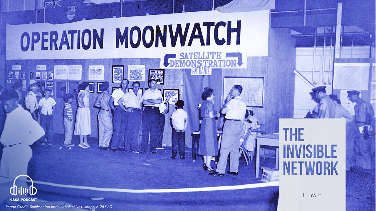
Enter Operation Moonwatch.
Moonwatch was founded by the Smithsonian Astrophysical Observatory in 1956. Until professionally operated optical tracking stations came online in 1958, the amateur skywatchers of Moonwatch would play a critical role, providing crucial information regarding the orbital dynamics of the world’s first artificial satellites. It sounds crazy, but amateur scientists using homemade telescopes and ham radio equipment were some of the only groups capable of spotting Sputnik. Their data was all we had.
Though advanced tracking systems would take over navigation, Moonwatchers, these citizen-astronomers, remained important to NASA. The agency would continue to provide some funding for Operation Moonwatch until 1975, the year it disbanded.
We’ve come a long way since the early days of space navigation. Those tracking systems that took over for the Moonwatchers pale in comparison to today’s robust navigation infrastructure. Our methods have improved, our technological capabilities have grown, but the field of space tracking and navigation still hasn’t reached its zenith. There are opportunities for growth, opportunities to mature, challenges to surmount… especially in deep space.
In deep space, because most spacecraft lack an accurate time-keeping device, missions using the Deep Space Network’s ground stations for tracking must wait for the spacecraft to return a signal to Earth. Using this method, each ground antenna can only track one spacecraft at a time. Additionally, spacecraft have to wait for navigation commands from Earth rather than making those decisions onboard and in real time. From Mars, this delay can be as much as 24 minutes both ways.
A spacecraft with an accurate time-keeping device could use a signal sent from Earth to calculate position without returning the signal and waiting for commands from the ground, a process that can take hours. Spacecraft using this technology would no longer have to rely on two-way tracking, allowing for more efficient operations, more precise maneuvering and adjustments to unexpected situations. Autonomous onboard navigation also becomes more feasible.
Additionally, this paradigm shift would enable spacecraft to focus on mission objectives rather than adjusting their position to point antennas Earthward to close a link for two-way tracking. Also, this innovation would allow ground stations to track multiple satellites at once near areas like Mars, crowded with NASA science missions. In certain scenarios, the accuracy of that tracking data would exceed traditional methods by a factor of five.
Unfortunately, hyper-accurate atomic clocks designed for space are typically relatively large devices that require a big portion of the spacecraft’s available power, making them impractical in most cases. For missions, space is at a premium and added weight can mean a prohibitively expensive launch. Smaller atomic clocks designed for space lack the stability and accuracy necessary to support deep space autonomous navigation.
…
For 20 years, NASA’s Jet Propulsion Laboratory, has been perfecting a new type of atomic clock for use in space.
The Deep Space Atomic Clock is an advanced prototype of a small, low-mass atomic clock using mercury ions to keep time. The clock aims to provide accurate onboard timekeeping for future NASA missions. The atomic clocks at ground stations in the Deep Space Network are about the size of a refrigerator, far too large to be a practical addition to most spacecraft. The Deep Space Atomic Clock? It’s about the size of a four-slice toaster, and could be further miniaturized for future missions.
Other NASA-developed technologies turn once again to the stars, offering new methods of celestial navigation that ship-bound navigators of antiquity couldn’t even conceive of.
The Station Explorer for X-Ray Timing and Navigation Technology, a space station experiment whose acronym SEXTANT cheekily references a tool used by mariners to judge the angle between a star and the horizon line, looks at pulsars to accurately determine its location and velocity while moving thousands of miles per hour in space.
SEXTANT is a navigation experiment embedded within the Neutron-star Interior Composition Explorer, making use of its 52 X-ray telescopes. The instrument studies the composition of neutron stars by observing the X-ray radiation they emit. Pulsars are rotating neutron stars, whose emissions appear to pulsate to distant observers. Some of these pulses are so regular that they exhibit atomic clock-like stability. Thus, they can provide high-precision timing and navigation information similar to the signals transmitted by GPS satellites.
A future, pulsar-based navigation system could use X-ray telescopes coupled with a precise time reference like the Deep Space Atomic Clock to provide a comparable onboard navigation capability to GPS in deep space.
All of these technologies from SEXTANT to the Deep Space Atomic Clock, clocks that count the seconds through neutron stars and tiny atoms, will inform the future of space exploration. When we finally step foot on the Red Planet, or even venture beyond, NASA will make sure that our astronauts will never truly be lost.
…
In 2001, work began transforming Old Albuquerque High School into chic loft apartments. Amenities include laundry facilities, a large, furnished lobby in what used to be the gymnasium and an elevator. Red brick still occupies the bulk of the building’s facade, accompanied by a kind of medieval ornament. This was typical of the Gothic Revival style, popular when the high school’s first building was constructed around the turn of the century.
I wonder if the building’s current residents know how special it is. I wonder if they know about Mrs. Hefferan… about teenage Moonwatchers on the roof above them, pointing makeshift telescopes towards an inky, bespeckled night… about Sputnik… about uncertainty… about life without GPS…
Mostly, I wonder if they think about adolescence… about an adolescent nation gazing skyward, learning to navigate through life at the dawn of the space age.
…
The Invisible Network is a NASA podcast presented by theSpace Communications and Navigation program. This episode was written by me, Danny Baird, and released on Oct. 16, 2018. Editorial oversight provided by Ashley Hume. Our public affairs officers are Clare Skelly and Peter Jacobs. Make sure to subscribe wherever you get your podcasts and share us with a friend. For the full text of this episode, a list of sources and related images visit nasa.gov/SCaN.
To explore NASA citizen science opportunities, visit:https://www.nasa.gov/solve/opportunities/citizenscience