


![Request for Information – Potential [Placeholder for Prize]](https://assets.science.nasa.gov/dynamicimage/assets/science/psd/solar/2023/09/s/solarsystem_0.jpg?w=1024)


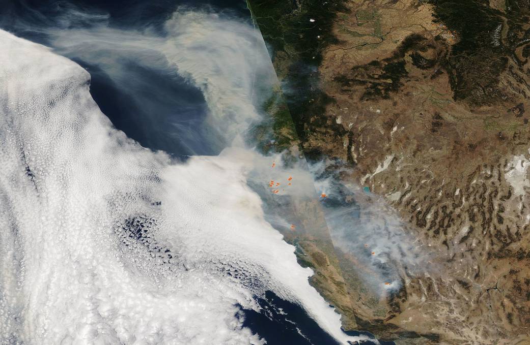
NASA’s Aqua satellite captured this composite visible and infrared image on Sep. 29, 2020, (https://go.nasa.gov/30lnTId) and the image shows that fires and smoke continue to dominate the landscape of the western states in the U.S. The visible image shows the smoke and the infrared image shows the heat from the fires (orange points). The CAL Fire page for Sep. 30 finds many large fires still active throughout California and the Pacific Northwest. The August Complex in California continues to be the largest wildfire still active and uncontained at 949,055 acres, located in Glenn, Lake, Mendocino, Tehama, and Trinity Counties. The August Complex is the largest wildfire in California’s history having surpassed the Mendocino Complex fire which burned 459,123 acres in July 2018. In this image, the smoke which had previously crossed the country by heading east has now shifted and is heading out to the west, billowing out over the Pacific Ocean.
Further complicating the fighting of the fires is the weather pattern predicted by the National Interagency Fire Center (NIFC) in its daily report from Sep. 30, 2020: “A broad upper ridge building over the West will yield increasingly hot, dry, and unstable conditions for California, the Desert Southwest, and the Great Basin. Fires actively burning in Northern California will be challenged by near or record-breaking heat and very low relative humidities.” The NIFC also provides predictive maps to show areas that have above normal significant wildland fire potential here: https://www.predictiveservices.nifc.gov/outlooks/month1_outlook.png
NASA’s satellite instruments are often the first to detect wildfires burning in remote regions, and the locations of new fires are sent directly to land managers worldwide within hours of the satellite overpass. Together, NASA instruments detect actively burning fires, track the transport of smoke from fires, provide information for fire management, and map the extent of changes to ecosystems, based on the extent and severity of burn scars. NASA has a fleet of Earth-observing instruments, many of which contribute to our understanding of fire in the Earth system. Satellites in orbit around the poles provide observations of the entire planet several times per day, whereas satellites in a geostationary orbit provide coarse-resolution imagery of fires, smoke and clouds every five to 15 minutes. For more information visit: https://www.nasa.gov/mission_pages/fires/main/missions/index.html
NASA’s Earth Observing System Data and Information System (EOSDIS) Worldview application provides the capability to interactively browse over 700 global, full-resolution satellite imagery layers and then download the underlying data. Many of the available imagery layers are updated within three hours of observation, essentially showing the entire Earth as it looks “right now.” Actively burning fires, detected by thermal bands, are shown as orange points. Image Courtesy: NASA Worldview, Earth Observing System Data and Information System (EOSDIS). Caption: Lynn Jenner with information from NIFC, CAL Fire, and Worldview.