


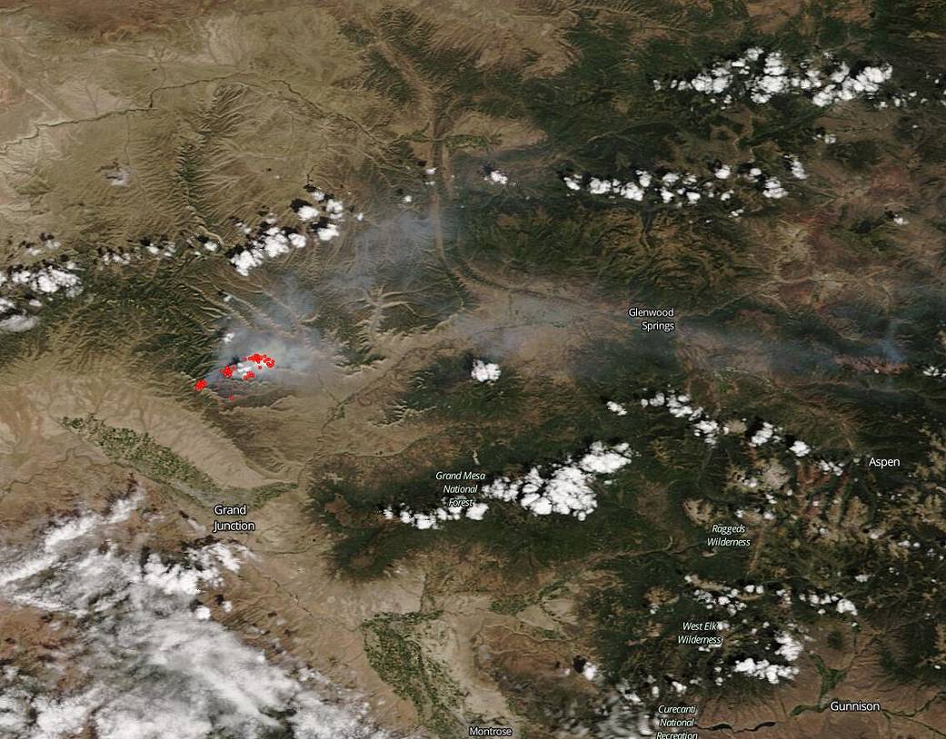
NASA’s Aqua satellite was able to capture this image of the Pine Gulch Fire near Grand Junction, Colorado on Aug. 09, 2020. The Pine Gulch fire began on July 31, 2020 eighteen miles north of Grand Junction with a lightning strike. Eleven days later that fire has grown to 28,888 acres. The nature of the fire has been extreme due to critically dry fuels and winds out of the southwest which continued pushing the fire east and northeast through the day on Aug. 09. In addition, steady winds and low humidity are keeping the fire very active and will increase fire spotting (fire hopping from tree to tree or area or area) especially where wind and slope align. The probability of ignition, according to fire officials, is 95% with spotting distances of 2000 feet possible due to the high winds. The fire is 7% contained. There are 535 personnel battling the blaze. Also concerning is the smoke drift as evidenced in the Aqua satellite image. Smoke from the fire has traveled as far as the city of Vail which is 116 miles away.
NASA’s satellite instruments are often the first to detect wildfires burning in remote regions, and the locations of new fires are sent directly to land managers worldwide within hours of the satellite overpass. Together, NASA instruments detect actively burning fires, track the transport of smoke from fires, provide information for fire management, and map the extent of changes to ecosystems, based on the extent and severity of burn scars. NASA has a fleet of Earth-observing instruments, many of which contribute to our understanding of fire in the Earth system. Satellites in orbit around the poles provide observations of the entire planet several times per day, whereas satellites in a geostationary orbit provide coarse-resolution imagery of fires, smoke and clouds every five to 15 minutes. For more information visit: https://www.nasa.gov/mission_pages/fires/main/missions/index.html
NASA’s Earth Observing System Data and Information System (EOSDIS) Worldview application provides the capability to interactively browse over 700 global, full-resolution satellite imagery layers and then download the underlying data. Many of the available imagery layers are updated within three hours of observation, essentially showing the entire Earth as it looks “right now.” Actively burning fires, detected by thermal bands, are shown as red points. Image Courtesy: NASA Worldview, Earth Observing System Data and Information System (EOSDIS). Caption: Lynn Jenner with information from Inciweb.