


NASA/NOAA’s Suomi NPP satellite captured this image of the Mangum Fire in the Kaibab National Forest in Arizona on June 15, 2020. Because Highway 89A is closed from Marble Canyon to Fredonia, and Highway 67 is closed from Jacob Lake to the Grand Canyon National Park, the North Rim of the Grand Canyon National Park is presently inaccessible. The U.S. Forest Service has closed the entire fire area to entry.
This fire began on June 08, 2020 and the cause of the fire is still under investigation according to the Inciweb website. As of June 16, 2020, the Mangum fire has burned 29,689 acres and is only 3% contained. Inciweb is reporting that: “Incident meteorologists have alerted fire managers that fire weather conditions will deteriorate Tuesday including another red flag warning after 11 a.m. Ridgetop winds are to reach 35 miles per hour.”
NOAA/UW-Madison Cooperative Institute for Meteorological Satellite Studies (CIMSS) captured this image of the fire on June 14, 2020. This is the 250m MODIS view from Sunday afternoon. The false-color image provides information abou the actual extent of the burn scars from the fire, which appear red/brown in the greenish colored image. More information and imagery can be found on the CIMSS Satellite Blog at https://cimss.ssec.wisc.edu/satellite-blog/archives/37234

In addition, Aerosol Watch on Twitter (affiliated with NOAA) also captured this image of the fire which provides information about the aerosols being released from the Mangum Fire. This shows aerosol detection (pink shading) overlaid on GeoColor which highlights smoke plumes, while fire radiative power (FRP; yellow/orange dots) measure intensity of the fires. Animation is from the AerosolWatch website (https://star.nesdis.noaa.gov/smcd/spb/aq/AerosolWatch/…).

NASA’s satellite instruments are often the first to detect wildfires burning in remote regions, and the locations of new fires are sent directly to land managers worldwide within hours of the satellite overpass. Together, NASA instruments detect actively burning fires, track the transport of smoke from fires, provide information for fire management, and map the extent of changes to ecosystems, based on the extent and severity of burn scars. NASA has a fleet of Earth-observing instruments, many of which contribute to our understanding of fire in the Earth system. Satellites in orbit around the poles provide observations of the entire planet several times per day, whereas satellites in a geostationary orbit provide coarse-resolution imagery of fires, smoke and clouds every five to 15 minutes. For more information visit: https://www.nasa.gov/mission_pages/fires/main/missions/index.html
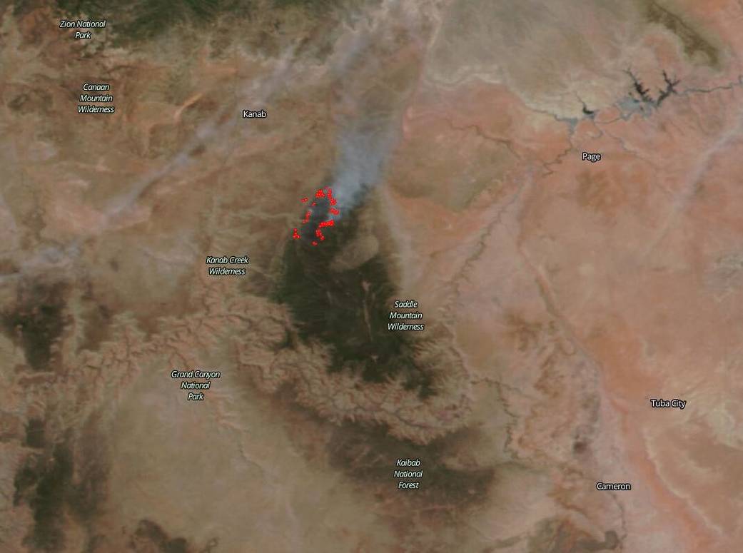
NASA’s Earth Observing System Data and Information System (EOSDIS) Worldview application provides the capability to interactively browse over 700 global, full-resolution satellite imagery layers and then download the underlying data. Many of the available imagery layers are updated within three hours of observation, essentially showing the entire Earth as it looks “right now.” This satellite image was collected on Actively burning fires, detected by thermal bands, are shown as red points. Image Courtesy: NASA Worldview, Earth Observing System Data and Information System (EOSDIS). Caption: Lynn Jenner with information from UW-Madison CIMSS, NOAA, and Inciweb.