


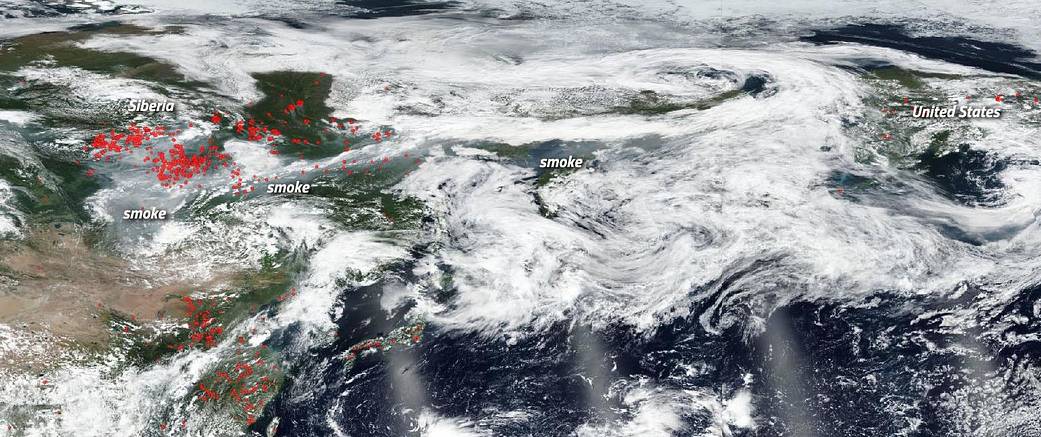
Fires in the Siberian area of Russia are usually quite severe by this time of year and 2019 is no exception. This NOAA/NASA Suomi NPP image taken on July 30, 2019 shows dozens to hundreds of fires burning across a large expanse of this mostly wilderness area of Russia. In fact, this year has been worse than most. Scientists have seen an unprecedented number of wildfires across the region since June. More than 2.7 million hectares (6,671,845 acres) of remote forest is currently burning across six Siberian and Far East regions, according to Russia’s Federal Forestry Agency. That’s roughly the size of Massachusetts.
According to the Moscow Times, authorities in the region are not trying to contain or extinguish these fires since the fires are in “hard-to-reach” areas, inhabited areas are “not under threat”, and “projected extinguishing costs exceed their projected harm.” The fallout of these fires is the smoke that is produced.

“The smoke looks to be arriving late tonight (July 30), but definitely by July 31, 2019,” said Colin Seftor, atmospheric scientist at NASA’s Goddard Space Flight Center in Greenbelt, Maryland. The date on the image refers to west of the dateline (the Siberian portion of the image.)
The smoke released by any type of fire (forest, brush, crop, structure, tires, waste or wood burning) is a mixture of particles and chemicals produced by incomplete burning of carbon-containing materials. All smoke contains carbon monoxide, carbon dioxide and particulate matter (PM or soot). Smoke can contain many different chemicals, including aldehydes, acid gases, sulfur dioxide, nitrogen oxides, polycyclic aromatic hydrocarbons (PAHs), benzene, toluene, styrene, metals and dioxins. The type and amount of particles and chemicals in smoke varies depending on what is burning, how much oxygen is available, and the burn temperature. All smoke can be hazardous especially for the young and elderly.
NASA’s Earth Observing System Data and Information System (EOSDIS) Worldview application provides the capability to interactively browse over 700 global, full-resolution satellite imagery layers and then download the underlying data. Many of the available imagery layers are updated within three hours of observation, essentially showing the entire Earth as it looks “right now.” This NASA/NOAA Suomi NPP satellite image was collected on July 29 (U.S. half) and July 30 (Siberian half), 2019. Actively burning fires, detected by thermal bands, are shown as red points. Image Courtesy: NASA Worldview, Earth Observing System Data and Information System (EOSDIS). Caption: Lynn Jenner