


![Request for Information – Potential [Placeholder for Prize]](https://assets.science.nasa.gov/dynamicimage/assets/science/psd/solar/2023/09/s/solarsystem_0.jpg?w=1024)


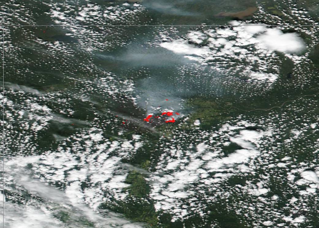
No rest for Alberta Canada’s firefighting force this summer. On July 18, 2019, NASA/NOAA’s Suomi NPP satellite saw that the High Level area in northern Alberta is still under siege from multiple fires and the resulting smoke. There are currently nine fires that make up the High Level complex of fires. Of those four are out of control, two are being held and three are listed as under control.
Below is a summary of the wildfires of note:
HWF127 is located 26 km (16 miles) west of Garden River and is considered out of control. It is 8 hectares [ha] (19.7 acres) in size. Four firefighters and one helicopter are engaged with this fire. There is no threat to any communities at present.
HWF126 is located 20 km (12.4 miles) northwest of Zama City and is considered out of control. The fire is 45 ha (111 acres) in size. Ten firefighters, two helicopters, air tankers and other heavy equipment are engaged with this fire. There is no threat to any communities at present.
HWF124 is located 10 km (6.2 miles) southeast of High Level and is considered under control. It is 4 ha (9 acres) in size. Twenty-one firefighters and two helicopters are engaged with this fire. There is no threat to any communities at present.
HWF117 is located approximately 8 km (5 miles) southwest of Chateh and is extinguished. No resources are engaged with this fire. It is 1.5 ha (3.7 acres) in size. There is no threat to any communities at present.
HWF113 is located 62 km (38.5 miles) southeast of the Rainbow Lake and is out of control. It is 132 ha (326 acres) in size. Forty-one firefighters and air tankers are engaged with this fire. There is no threat to any communities at present.
The Jackpot Creek Fire (HWF066) is located north of Lutose and is under control. It is 74,331 ha (183,676 acres) in size. Thirty-two firefighters, nine helicopters, and heavy equipment are engaged with this fire.
The Chuckegg Fire is by far the largest fire in the High Level complex at 338,648 hectares (836,817 acres). Nine hundred twenty-one firefighters and support staff, 48 helicopters and 125 pieces of heavy equipment are engaged with this fire. Fire activity on July 18, 2019 was quieter due to smoke coverage and weather over the eastern portion which made visibility difficult for firefighters and helicopters. Two fingers of the fire south and southwest of Devil Lake are making their way towards the fireguard but are expected to lose momentum as it nears closer to swampy land.
Extreme fire behavior potential is expected for tomorrow as crossover conditions are likely to occur, meaning the temperature will be higher than the relative humidity in the air. Temperatures should reach 28 degrees C (82 degrees F) with a relative humidity of 20-25%. Winds will be from the north/northwest at 10 km/hr (6 mph), therefore communities south/southeast of the fire may experience an increase in smoke.
A Fire Advisory remains in effect due to the hotter temperatures, no significant rainfall and the ongoing wildfire activity within the High Level Forest Area.
NASA’s Earth Observing System Data and Information System (EOSDIS) Worldview application provides the capability to interactively browse over 700 global, full-resolution satellite imagery layers and then download the underlying data. Many of the available imagery layers are updated within three hours of observation, essentially showing the entire Earth as it looks “right now.” NASA/NOAA’s Suomi NPP satellite collected this natural-color image using the VIIRS (Visible Infrared Imaging Radiometer Suite) instrument on July 18, 2019. Actively burning fires, detected by thermal bands, are shown as red points. Image Courtesy: NASA Worldview, Earth Observing System Data and Information System (EOSDIS). Caption: Lynn Jenner with information from Alberta Wildfire.