


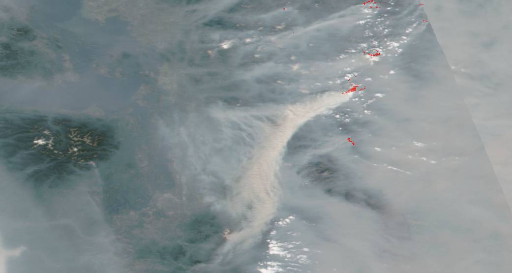
Washington’s Crescent Mountain fire is spewing copious amounts of smoke into the atmosphere. This NASA image shows the huge plume rising from the fire and drifting along the jet stream. The skies above Washington state continue to be obscured by this smoke and the smoke from other fires around the state, as well as from Oregon and California wildfires as well.
The Crescent Mountain Fire began on July 29, 2018 with a lightning strike. It is currently 23,764 acres and is 34% contained. It continues to move south on the west side of the Twisp River north of Eagle Creek. A control line is in place on Scaffold Ridge. Crews are holding the fire east of Eagle Creek and working on contingency lines from the Twisp River to Buttermilk Butte. Crews will continue monitoring and holding the line east of the Twisp River and north of Poplar Flat.
The smoke was thinner today after a recent cold front from Canada. Winds from the northeast carried smoke southwest. Temperatures warmed into the 70s on the upper portions of the Crescent Fire and around 85 in the lower Twisp River Valley. Afternoon humidity values dropped between 18 and 25 percent with the cooler temperatures. Winds up to 10 mph gusting to 20 mph on the ridges switched from northwest to east around noon. Wind is especially dangerous as this is the primary vehicle that pushes fires across containment lines. Tomorrow the smoke will continue to thin with lighter winds. Temperatures will climb to around 87 over the lowest elevations of the fires and near 73 over the higher portions of the fires around 5000 feet. Winds will be trending from the east at 5 to 10 mph.
NASA’s Earth Observing System Data and Information System (EOSDIS) Worldview application provides the capability to interactively browse over 700 global, full-resolution satellite imagery layers and then download the underlying data. Many of the available imagery layers are updated within three hours of observation, essentially showing the entire Earth as it looks “right now. This image was collected on August 20, 2018. Actively burning areas, detected by thermal bands, are outlined in red. NASA image courtesy NASA/Goddard Space Flight Center Earth Science Data and Information System (ESDIS) project. Caption: Lynn Jenner with information from Inciweb.