


The Mendocino Complex fire is now entering its 19th day and still the complex grows in size. Today the fire is 354,410 acres and 68% contained. The River fire is completely contained and there has been no further movement, but the Ranch fire portion of the complex continues to grow northward. On Monday, tragically a firefighter who had come from Utah to help fight the blaze died from injuries he sustained he on the job. That is the sixth firefighter who has lost his life this fire season in California.
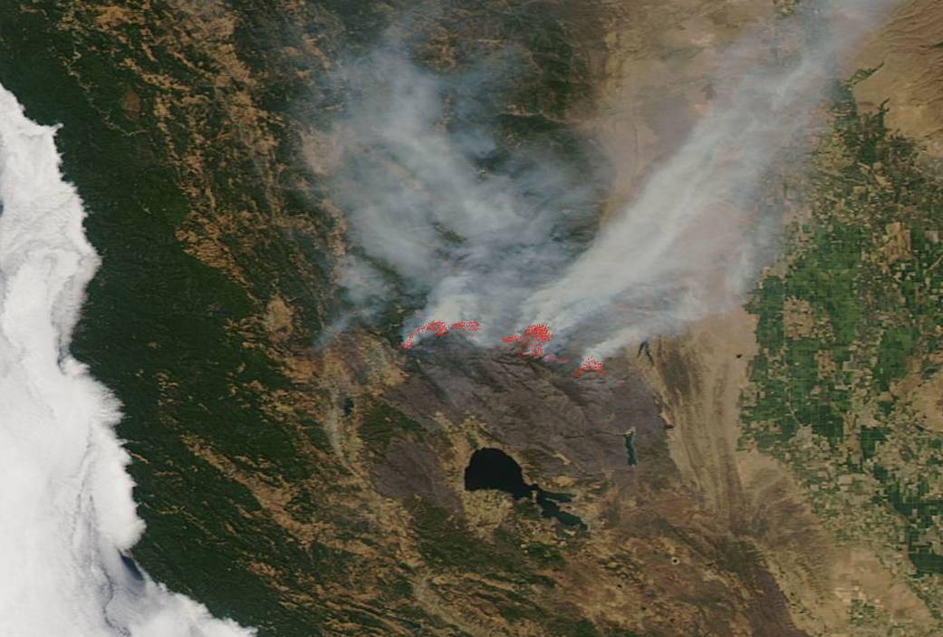
Smoke continues to billow from the active fire area within the Ranch portion of the complex. The dark red-brown area below the smoke in the satellite image contrasts starkly with the lighter tan and green areas. That red-brown area is the scorched earth left behind after the fire has burned out and moved on. In this satellite image the fire complex has nearly ringed Clear Lake and continues to move northward.
The detailed map below from CAL Fire shows the area that has been affected by the Mendocino Complex in vivid detail:

The fire is using tall grass (2.5′), brush (2′), and dormant brush/hardwood slash as fuels. Concerns for this fire include active fire movement, flanking (fire that parallels wind direction), backing (fire backing into the wind with relatively short flame lengths and slow rates of spread), and creeping (spreading slowly with low flames).
Once again high temperatures, low humidity, and winds are all causes for ongoing concern with this fire. These are the three areas of weather concern that continue to plague all ongoing California fires.
This Aqua satellite image was captured on August 13, 2018. Actively burning areas (hot spots) are outlined in red. Each hot spot is an area where the thermal detectors recognized temperatures higher than background. When accompanied by plumes of smoke, as in this image, such hot spots are diagnostic for fire. NASA image courtesy of the NASA/Goddard Space Flight Center Earth Science Data and Information System (ESDIS) project. Caption by Lynn Jenner with information from CAL fire and Inciweb.