Fire is devastating. It consumes. It destroys and leaves behind a pernicious force in the form of smoke. Although most people might think that smoke rises and then clears after a fire has been extinguished the opposite is actually true. New research using data collected during NASA airborne science campaigns shows how smoke from wildfires worldwide could impact the atmosphere and climate much more than previously thought. The study, led by researchers at the Georgia Institute of Technology, found brown carbon particles released into the air from burning trees and other organic matter are much more likely than previously thought to travel to the upper levels of the atmosphere, where they can interfere with rays from the sun – sometimes cooling the air and at other times warming it.
Quoting from the NASA.gov feature: “Researchers found surprising levels of brown carbon in the samples taken from the upper troposphere — about seven miles above the Earth’s surface — but much less black carbon. While black carbon can be seen in the dark smoke plumes rising above burning fossil or biomass fuels at high temperature, brown carbon is produced from the incomplete combustion that occurs when grasses, wood or other biological matter smolders, as is typical for wildfires. As particulate matter in the atmosphere, both can interfere with solar radiation by absorbing and scattering the sun’s rays.
According to other research conducted by NASA in recent years, the increase in brown-and-black-carbon-producing wildfires that rage across the U.S. every year could itself be a symptom of a warming world. A 2015 analysis of 35 years of meteorological data confirmed that fire seasons have become longer. In addition, climate models predict fire seasons will continue to increase in length and strength across the U.S. in the next 30 to 50 years.
As carbon particulates released by those fires migrate higher into the atmosphere, the climate becomes more sensitive to them. The researchers found brown carbon to be much more likely than black carbon to travel through the air to the higher levels of the atmosphere where it can have a greater impact on climate.” For more on this research, visit the feature webpage here: https://www.nasa.gov/feature/langley/smoke-from-wildfires-can-have-lasting-climate-impact
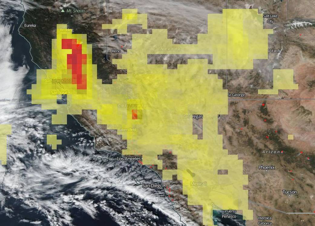
In this image taken on November 15, 2018 from NASA’s Suomi NPP satellite the levels of ozone from the ongoing California fires were mapped using the Ozone Mapping Profiler Suite (OMPS)/ National Polar orbiting Partnership (NPP) Total Column Ozone Product 1-Orbit L2 Swath. The OMPS Aerosol Index layer indicates the presence of ultraviolet-absorbing particles in the air (aerosols) such as soot particles in the atmosphere; it is related to both the thickness of the aerosol layer located in the atmosphere and to the height of the layer. The Aerosol Index is a unitless range from =5.00, where 5.0 (red) indicates heavy concentrations of aerosols that could reduce visibility or impact human health. The Aerosol Index layer is useful for identifying and tracking the long-range transport of smoke from wildfires or biomass burning events even tracking over clouds and areas of snow and ice.
Aerosols have an effect on human health, weather and the climate. Aerosols compromise human health when inhaled by people with asthma or other respiratory illnesses. Aerosols also have an affect on the weather and climate by cooling or warming the earth, helping or preventing clouds from forming.
NASA’s Earth Observing System Data and Information System (EOSDIS) Worldview application provides the capability to interactively browse over 700 global, full-resolution satellite imagery layers and then download the underlying data. Many of the available imagery layers are updated within three hours of observation, essentially showing the entire Earth as it looks “right now.” Actively burning fires, detected by thermal bands, are shown as red points. Image Courtesy: NASA Worldview, Earth Observing System Data and Information System (EOSDIS). Caption: Lynn Jenner with information from Langley Research Center and Worldview.


