


Chapada dos Veadeiros National Park is a national park of Brazil located in the Chapada dos Veadeiros, an ancient plateau with an estimated age of 1.8 billion years, also within the area of the Cerrado, known as the Brazilian savannah and making up 25% of Brazil’s total acreage. Based in the Brazilian state of Goias, the national park occupies an area of 655 square kilometres (253 sq mi) in the municipalities of Alto Paraíso de Goiás, Cavalcante and Colinas do Sul. The park is maintained by Chico Mendes Institute for Biodiversity Conservation.
The Cerrado, an ecologically important area not only in Brazil but also for the world has over 10,000 species of plants – 45 percent of which are endemic, or unique to the region. The Cerrado (of which the Chapada National Park is a small portion) is the world’s most biologically rich savanna. This area, unfortunately, is systematically being destroyed by (almost 60 percent) by deforestation, agricultural expansion, and fires at a rate of almost twice as fast as the Amazon. What it presents is a varied geography, ranging from dense grassland usually sparsely covered by shrubs and small trees, to an almost closed woodland. Interestingly the biggest forest in the Cerrado is underground: a huge system of branches and roots buried deep enough to survive fire and search for water during long dry seasons. Among some species, up to 70 percent of the plants are underground – which is why the Cerrado is sometimes referred to as the “the upside-down forest.”
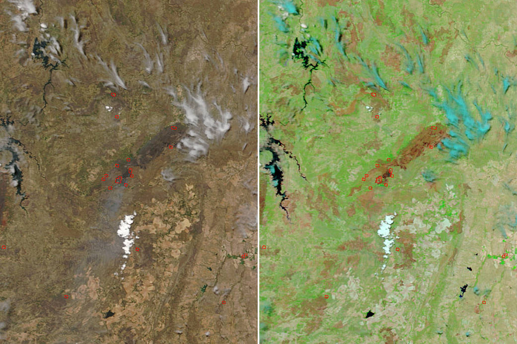
These images show a large portion of the Chapada dos Veadeiros National Park that has been burned by wildfires. The two images are from the Terra satellite. The image on the left shows the true color image of the area, and the left hand image shows the false color image which highlights more clearly the area that is affected by wildfires. Below are two images that show the area before the fire began. Those images (both true and false color images) were taken on October 06, 2017.

NASA’s Aqua satellite collected all images above with the Moderate Resolution Imaging Spectroradiometer, MODIS, instrument. The main image was collected on October 22, 2017 and the images directly above on October 06, 2017. Actively burning areas (hot spots), detected by MODIS’s thermal bands, are outlined in red. Each hot spot is an area where the thermal detectors on the MODIS instrument recognized temperatures higher than background. When accompanied by plumes of smoke, as in this image, such hot spots are diagnostic for fire. NASA image courtesy Jeff Schmaltz LANCE/EOSDIS MODIS Rapid Response Team, GSFC. Caption by Lynn Jenner with information from http://www.dw.com