


From cities to deserts, the intense heat gripping California is being closely monitored by an Earth-observing mission aboard the International Space Station.
As record temperatures and large wildfires scorch California, NASA’s Ecosystem Spaceborne Thermal Radiometer Experiment on Space Station (ECOSTRESS) has been tracking the heat wave from low Earth orbit. While ECOSTRESS’s primary mission is to measure the temperature of plants heating up as they run out of water, it can also measure and track heat-related phenomena like heat waves, wildfires, and volcanoes.
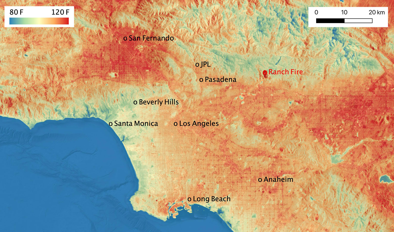
At 3:56 p.m. PDT (6:56 p.m. EDT) on Aug. 14, as the space station passed over Los Angeles, ECOSTRESS was able to take a snapshot of the soaring land surface temperatures across the county, home to more than 10 million people. (Land surface temperature is the temperature of the ground rather than the air above it.) In the first image, ECOSTRESS measured a temperature range of about 70-125 degrees Fahrenheit (21-52 degrees Celsius), with the coolest being at the coasts and mountains. The highest surface temperatures, in dark red, were found northwest of downtown Los Angeles in the San Fernando Valley. (The instrument also captured the Ranch fire, seen in the center of the image, as it burned.) Land surface temperatures there reached over 125 degrees Fahrenheit (52 degrees Celsius), with a peak of 128.3 degrees Fahrenheit (53.5 degrees Celsius) between the cities of Van Nuys and Encino.
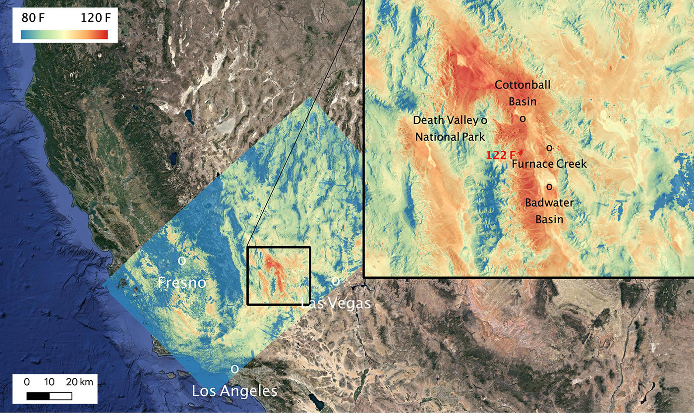
Those afternoon peaks were within range of morning surface temperatures ECOSTRESS gauged two days later in Death Valley, part of California’s Mojave Desert. As shown in the second image, from Aug. 16 at 8:50 a.m. PDT (11:50 a.m. EDT), ECOSTRESS recorded a maximum temperature of 122.52 degrees Fahrenheit (50.29 degrees Celsius) near Furnace Creek in Death Valley National Park.
ECOSTRESS observations have a spatial resolution of about 77 by 77 yards (70 by 70 meters), which enables researchers to study surface-temperature conditions down to the size of a football field. Due to the space station’s unique orbit, the mission can acquire images of the same regions at different times of day, as opposed to crossing over each area at the same time of day like satellites in other orbits do. This is advantageous when monitoring plant stress in the same area throughout the day, for example.
The ECOSTRESS mission launched to the space station on June 29, 2018. NASA’s Jet Propulsion Laboratory, a division of Caltech in Pasadena, California, built and manages the mission for the Earth Science Division in the Science Mission Directorate at NASA Headquarters in Washington. ECOSTRESS is an Earth Venture Instrument mission; the program is managed by NASA’s Earth System Science Pathfinder program at NASA’s Langley Research Center in Hampton, Virginia.
More information about ECOSTRESS is available here:
https://ecostress.jpl.nasa.gov
For information on Earth science activities aboard the International Space Station, visit:
https://www.nasa.gov/issearthscience
Ian J. O’Neill / Jane J. Lee
Jet Propulsion Laboratory, Pasadena, Calif.
818-354-2649 / 818-354-0307
ian.j.oneill@jpl.nasa.gov / jane.j.lee@jpl.nasa.gov
2020-161