


![Request for Information – Potential [Placeholder for Prize]](https://assets.science.nasa.gov/dynamicimage/assets/science/psd/solar/2023/09/s/solarsystem_0.jpg?w=1024)


In April 2019, an international team of more than 300 scientists unveiled the first recorded images of a black hole, its dark shadow and vivid orange disk peering back across 55 million light years of space. Capturing images from so far away required the combined power of eight radio telescopes across four continents, working together to essentially form a massive Earth-sized telescope called the Event Horizon Telescope (EHT).
The technology that powers EHT imaging is also used by scientists at NASA and worldwide to measure the Earth. Very long baseline interferometry, or VLBI, is a technique that combines waveforms recorded by two or more radio telescopes. This versatile tool is used not only in astronomy, but also geodesy: The science of measuring Earth’s size, shape, rotation and orientation in space.
Geodesy lets us see maps on our phones, measure ocean tides, plan rocket launches, calibrate clocks, forecast earthquakes, track tsunamis and maintain satellite orbits. As a geodetic tool, VLBI helps scientists precisely measure distances and topography and track changes to Earth’s surface and rotation over time. Scientists at NASA’s Goddard Space Flight Center in Greenbelt, Maryland, and MIT’s Haystack Observatory in Westford, Massachusetts, pioneered the geodetic use of VLBI in the 1960s.
Today, NASA, MIT Haystack and other partners collaborate to improve and expand geodetic stations around the world as part of NASA’s Space Geodesy Project (SGP). MIT Haystack serves as the hub for hardware and software development that benefits both astronomy and geodesy, partnering with the National Science Foundation to support the EHT and with NASA to boost the SGP. Together, that synergy contributed directly to realizing the black hole image while working towards smaller, faster radio telescopes, more automation and access to multiple geodetic tools in the same place, enabling more precise maps, charts, flight paths and orbits than ever before.
VLBI: All About That Baseline
Radio telescopes measure radio waves. These waves are weaker and fainter than visible light, but they penetrate interstellar dust and gases and interference from Earth’s own atmosphere in ways that visible light cannot. They also give astronomers information about space that does not exist in the visible spectrum.
Viewing radio waves requires large, sensitive telescopes. A VLBI array has magnifying power, or “angular resolution,” equivalent to a single telescope with a dish as wide as the longest baseline between two telescopes in the array. (For example, the EHT’s most distant telescopes were separated by more than 7,000 miles, equaling a single telescope more than twice as wide as the United States.) Each telescope in the EHT array captured the radio waves emitted by the black hole from a unique angle, depending on their location on Earth. Adding all these observations together with a powerful computer yielded the final images.
In the 1960’s, scientists at NASA Goddard and MIT Haystack realized that this slight difference in perspective was a valuable source of information — not just about space, but about Earth.
“The basic principle of geodetic VLBI is that radio waves coming in from a distant source hit one station before the other,” said Stephen Merkowitz, manager of NASA’s Space Geodesy Project. “We use quasars, which are very distant active galaxies, so far away that they are fixed points in the sky. We measure the time delay between when the signal hits those two points, and convert to a distance using the speed of light.”
Earth’s rotation causes changes to the time delay between the quasar signals observed by the VLBI stations, allowing scientists to precisely measure the rotation’s speed. They can also use this data to measure the location and distance between the VLBI stations, and by repeating these measurements over time, can observe even tiny, slow changes to the Earth’s surface, like continental drift.
Perhaps VLBI’s most important function is helping to build the International Terrestrial and Celestial Reference Frames. The Terrestrial Reference Frame assigns coordinates to locations on Earth, including its center, providing a consistent framework to relate measurements to each other.
“Suppose you have a mission that measures the sea level in the Gulf of Mexico and have a tide gauge off the coast of Louisiana that is also taking sea level measurements, and you want to tie those together so you have some ground truth to the space observations,” Merkowitz said. “If they’re not in the same reference frame, you can’t do that. If your frame isn’t precise and stable, that will introduce all kinds of errors into that tie. So, a good reference frame allows you to connect different data sets through geolocation.”
The Celestial Reference Frame serves a similar purpose, but instead of creating a stable framework for Earth locations, it creates a framework for locating astronomical objects. Scientists use Earth Orientation Parameters — measurements of time, orientation and rotation — to link the two frames together. This creates a total system to geolocate objects in space and on Earth.
One example of an everyday technology that depends on these reference frames is the Global Positioning System, or GPS. GPS relies on a constellation of satellites constantly broadcasting their locations and times to GPS-enabled devices on the ground, from cell phones to farm equipment. The satellites in the constellation rely on the Terrestrial Reference Frame and the Earth Orientation Parameters to relay their location, so keeping those frameworks precise and accurate is essential for daily activities around the world.
Quantities we sometimes take for granted, like the length of Earth’s day and how fast it rotates, are not actually constant, Merkowitz said. “They depend on lots of different things like weather, major mass motions like El Niño or La Niña, and movements of large amounts of water,” he explained.
Charting a Course for Geodesy’s Future
Credits: NASA
With Earth constantly changing, geodesy keeps maps accurate, planes and ships on course and satellite measurements precise. In fact, VLBI and other tools are vital for Earth-observing satellites like ICESat-2 and instruments like GEDI, both of which use laser pulses to measure the structures of ice sheets and forests. Without knowing exactly where the spacecraft are located above Earth’s surface, scientists wouldn’t be able to make these kind of precision measurements.
“When you do precision orbit determination for something like ICESat-2, it requires the reference frame as input,” Merkowitz said. “ICESat-2 is very sensitive to errors, so if the calculation of Earth’s center is off, it translates into an error in the science measurements. Precision orbit missions and missions that measure heights are particularly dependent on the framework.”
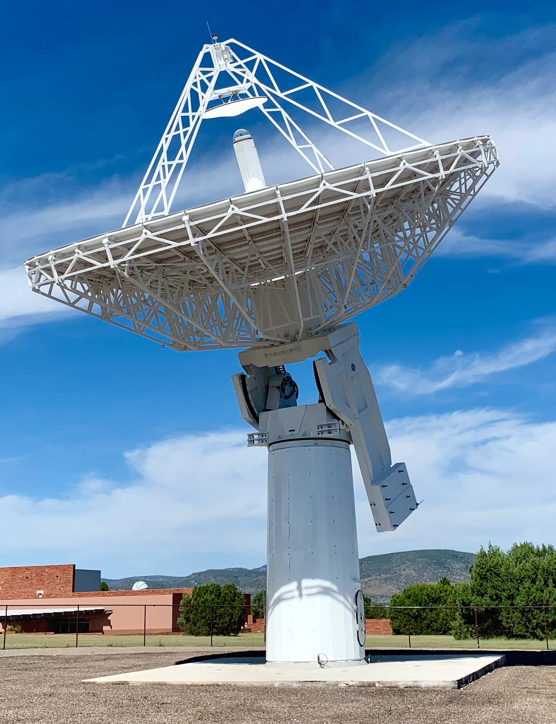
In 2007, the National Academy of Sciences reported that the nation’s geodesy infrastructure was aging too quickly to keep up with growing demands for data. So NASA launched the Space Geodesy Project to develop and deploy the next generation of geodetic stations, which includes VLBI as well as other techniques that use lasers to precisely track satellites (called satellite laser ranging, or SLR).
The new VLBI stations will be able to sample across a broad range of frequencies instead of just two, giving them more flexibility to keep collecting data if there is interference from Wi-Fi or other signals. Their smaller size and quicker movement will make them more adaptable to atmospheric conditions, but to make up for the smaller dishes (remember, with radio telescopes, bigger is better), they will sample data much faster. Eventually, Merkowitz said, the systems will be able to collect data 24 hours a day without human supervision to provide much more rapid measurements.
The National Academy of Sciences and other international geodetic associations recommend that, for the best science outcomes, the updated Space Geodesy Network should be accurate to within one millimeter, or about the thickness of an ID card. It should also be stable to within one-tenth of a millimeter — the width of a human hair. This precision is crucial for measuring sea levels, which are increasing at about 3.4 millimeters, or 0.13 inches, per year, Merkowitz said.
The project is in its first phase: replacing NASA’s domestic geodetic stations with the next-generation systems. NASA recently installed its third domestic VLBI station in Texas; its next-generation VLBI stations in Hawaii and Maryland are already in operation and routinely taking measurements.
NASA is also working with international partners to help transition the international VLBI network to the next-generation technology, Merkowitz said. “International cooperation is vital to the success of space geodesy. Measuring global effects requires a global network, and NASA cannot do this alone.”
The next-generation network will support more precise GPS, increasingly precise reference frames and better support for the many ways we use maps in today’s world. With the help of VLBI, the team will help us know where we are – and where we’re going – with even more accuracy in the future.
By: Jessica Merzdorf
NASA’s Goddard Space Flight Center, Greenbelt, Md.