


NASA is a step closer to eventually discovering what lies up to 32 feet or 10 meters beneath the surfaces of Mars, the Moon or any airless body in the solar system — a region roughly the length of a three-story building.
Rafael Rincon, an engineer at NASA’s Goddard Space Flight Center in Greenbelt, Maryland, and University of Arizona scientist Lynn Carter are using NASA technology-development funding to mature the Space Exploration Synthetic Aperture Radar, or SESAR. It would be capable of gathering meter-scale images of ice deposits, lava flows, caves, natural resources, and fluvial channels that lie buried between beneath the surfaces of planets, moons, and other small bodies.
Current NASA instruments can probe the surface or tens to hundreds of miles inside the interior. However, near-surface regions targeted by SESAR remain hidden from view with current spaceflight instruments, said Rincon, who, along with Carter, created the instrument concept.
“Our instrument will bridge the gap in these observations,” Rincon said. “In fact, synthetic aperture radar technology, which we employ in our instrument, is the only remote-sensing technique capable of penetrating meters into the surface while still providing high-resolution images.”
With this radar data, scientists could obtain greater insights into how volcanism, cratering, and fluvial activity and other geologic processes shaped these bodies. They could determine how surface regolith — that is, the layer of dust, soil, broken rock, and other materials — developed over time. And they could locate regions potentially hospitable to life, search for safe havens for astronauts to take cover in case of an emergency, and measure the extent and depth of ice deposits or potential sources of water.
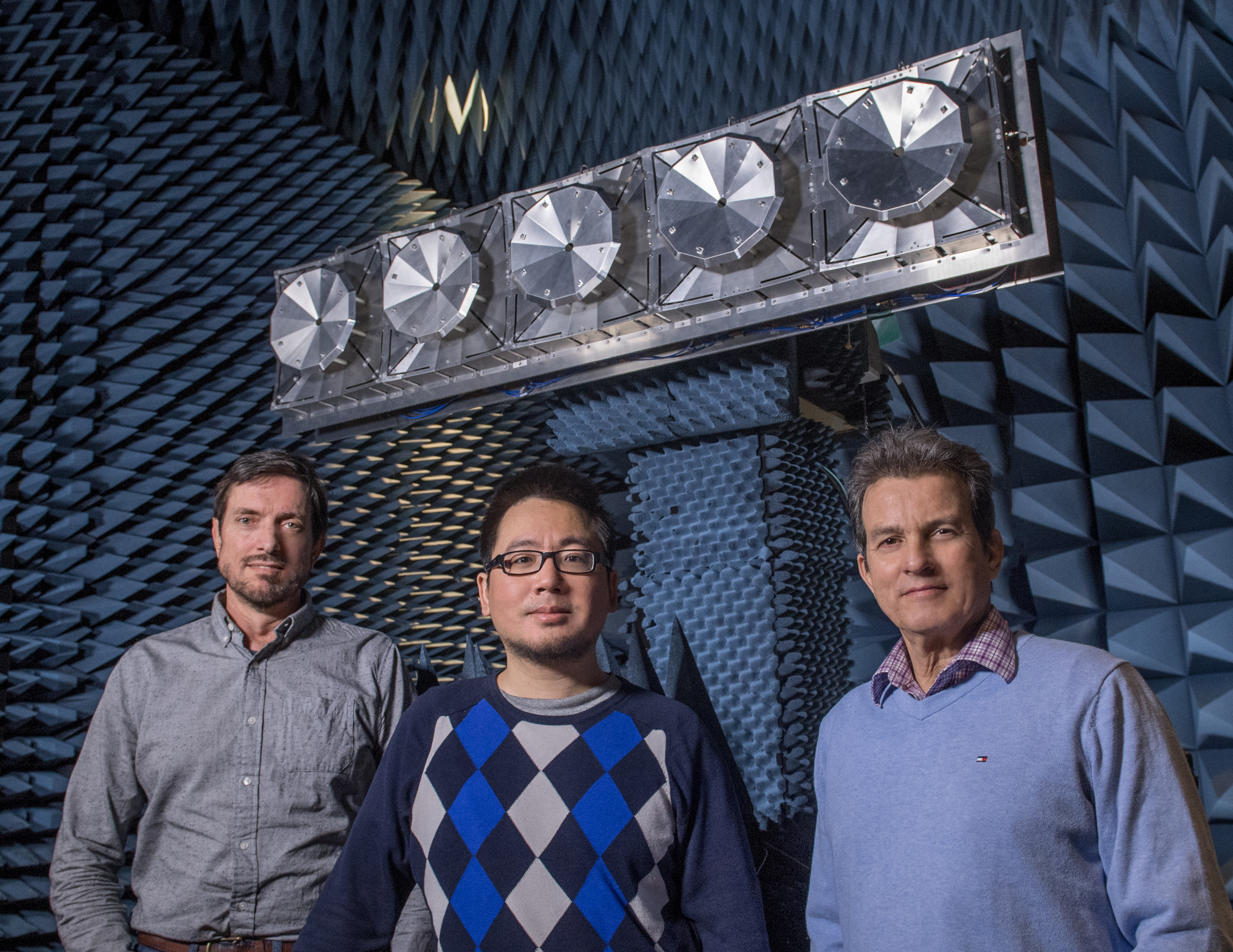
With funding from NASA’s Maturation of Instruments for Solar System Exploration (MatISSE) program, Rincon, Carter, and their team will build an instrument prototype and then test it in Goddard’s Electro-Magnetic Anechoic Chamber, which simulates conditions found in space. The goal, Rincon said, is to mature the instrument to the point where it could be proposed for a future mission once the funding ends in three years.
Legacy System
Rincon said he is confident of the team’s ultimate success.
SESAR is based on the L-Band Digital Beamforming Synthetic Aperture Radar, or DBSAR, which Rincon developed more than a decade ago. L-band is a microwave frequency range used for aircraft surveillance, telecommunications, and Earth remote sensing.
DBSAR demonstrated for the first time the ability to simultaneously synthesize multiple L-Band radar beams directed at targets below and then produce two-dimensional, high-resolution images of very large surface areas from the returning signals. Prior to its development, conventional synthetic aperture radar systems could only gather high-resolution data along a narrow swath on one side of the flight track.
Taking the technique one step further, Rincon and a colleague then adapted the same general approach to tune the system to the P-band — a lower microwave frequency ideal for piercing forest canopies and measuring biomass (CuttingEdge, Summer 2016, Page 9). The end result was an instrument called EcoSAR, which obtained unprecedented two-and three-dimensional fine-scale measurements of the biomass during its debut flight aboard a P-3 research aircraft in 2013.
Like EcoSAR, SESAR will operate in the P-band, which, as EcoSAR demonstrated, can penetrate meters of structure.
However, the team had to first overcome two major design challenges: the power required to steer the beams and the mass of the antenna. “We’ve successfully resolved both,” Rincon said.
With research and development funding, the team created a more efficient subsystem for steering the antenna, which must be relatively large to capture the P-band signal. In testing, the subsystem proved it could reduce power consumption by a factor of five compared with more conventional steering technologies.
Because the antenna must be large, it’s inherently heavy. To reduce its mass, the team constructed the antenna array with lightweight, structurally strong materials. It, too, was successfully tested at Goddard Electromagnetic Anechoic Chamber in March 2019. With the new funding, the team will further mature the instrument, aiming to reduce power consumption by a factor of 10. The improved performance will assure the instrument’s readiness for a future planetary mission, Rincon said.
For more Goddard technology news, go to: https://www.nasa.gov/wp-content/uploads/2019/06/spring_2019_final_web_version.pdf?emrc=188e7d
By Lori Keesey
NASA’s Goddard Space Flight Center