


Satellite Animation Shows Potential Tropical Cyclone 10 Fizzle
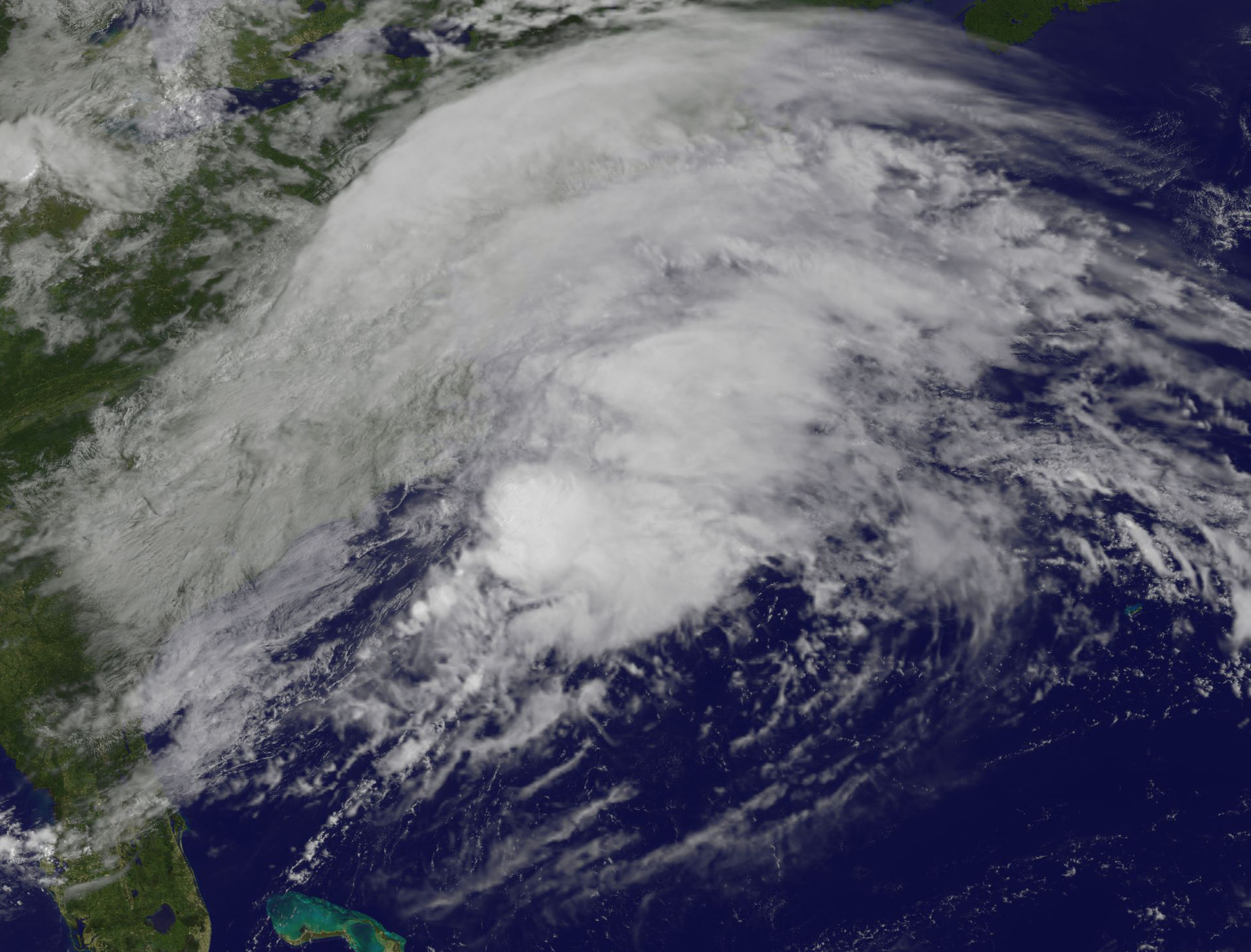
This animation of NOAA’s GOES East satellite imagery from 7:45 a.m. CDT (1245 UTC) Aug. 28 to 9:30 a.m. CDT (1430 UTC) Aug. 30 shows Tropical Storm Harvey in the Gulf of Mexico and what was Potential Tropical Cyclone 10 fizzle as it moved off the New England coast.
The animation shows Tropical Storm Harvey as it moves into the Gulf of Mexico and makes a second U.S. landfall in southwestern Louisiana.
Along the U.S. East coast, the other disturbance, previously known as “Potential Tropical Cyclone 10” that had potential for tropical development earlier this week is seen moving north of New England. There is no longer a possibility of this system becoming a tropical cyclone.
The National Weather Service in Taunton, Mass. said “an ocean storm passing southeast of New England will move further offshore today. This will be followed by weak high pressure building into the region this afternoon and tonight.
Increasing swell from the offshore storm combined with rough seas will lead to a high risk of rip currents. Southeast facing beaches will be most at risk. High Surf Advisory continues for coastal Rhode Island as well as much of south coastal MA during today, Aug 30.”
By Rob Gutro
NASA’s Goddard Space Flight Center
Aug. 29, 2017 – Potential Tropical Cyclone 10 Soaks Mid-Atlantic
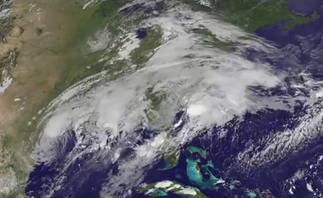
NOAA’s GOES East satellite provided an image of Potential Tropical Cyclone 10 as it continued moving north along the U.S. East Coast.
The system is still not a tropical cyclone and the chances for the system to become a tropical cyclone appear to be decreasing. Regardless, National Hurricane Center noted that tropical-storm-force winds and heavy rains are expected over portions of North Carolina later today, Aug. 29.
A Tropical Storm Warning was in effect from north of Surf City to Duck, North Carolina and for the Albemarle Sound and Pamlico Sound.
At NASA’s Goddard Space Flight Center in Greenbelt, Maryland, an image was created using visible light data from NOAA’s GOES-East satellite imagery on Aug. 29 at 10 a.m. EDT (1400 UTC). The image showed an elongated and large area of clouds stretching from northeast to southwest, stretching from South Carolina to New England. The disturbance developed an ill-defined center that has been trackable
NHC Forecaster Chris Landsea said that the disturbance “continues to display very cold, but extremely asymmetric deep convection with all of the thunderstorm activity east of the center due to strong vertical shear.”
NOAA manages the GOES series of satellites, and NASA uses the satellite data to create images and animations. The animation was created by the NASA/NOAA GOES Project at NASA’s Goddard Space Flight Center in Greenbelt, Maryland.
At 8 a.m. EDT on Aug. 28, the disturbance was moving northeastward past Cape Fear, North Carolina. The Potential Tropical Cyclone 10 (PTC10) was centered near 34.1 degrees north latitude and 77.7 degrees west longitude, about 15 miles (25 km) southeast of Wilmington, North Carolina. Maximum sustained winds remain near 40 mph (65 kph) with higher gusts. The disturbance is not expected to change much in strength today.
The system was moving faster toward the northeast near 15 mph (24 kph) and is anticipated to accelerate east-northeastward during the next couple of days. The expected track will take the system along the North Carolina coast today before moving out to sea tonight.
The system is expected to become extratropical by 5 a.m. EDT on Aug. 30 or earlier when it interacts with a mid- to upper-level trough (elongated area) of low pressure.
For updated forecasts, visit: www.nhc.noaa.gov
By Rob Gutro
NASA’s Goddard Space Flight Center
Aug. 28, 2017 – NASA Takes Potential Tropical Cyclone 10’s Temperature
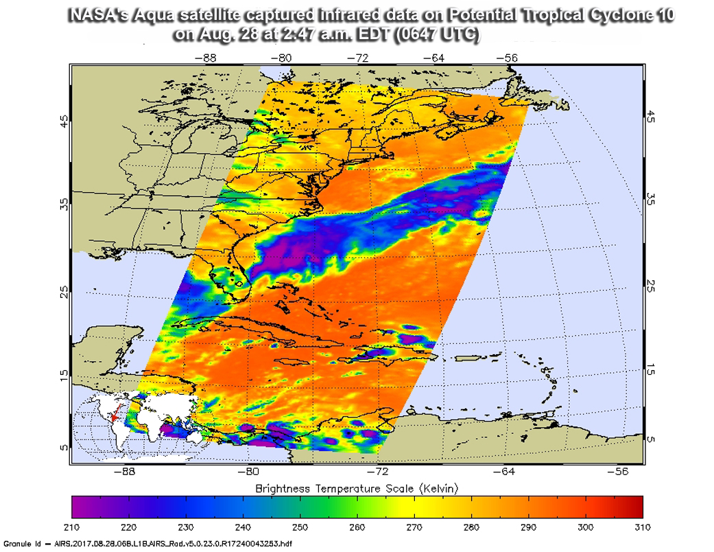
Cloud top temperatures are an important factor when it comes to determining the strength of storms. NASA’s Aqua satellite gathered cloud top temperature data from potential tropical cyclone 10, located in the Atlantic Ocean off the South Carolina coast.
On Aug. 28, the National Hurricane Center issued a Tropical Storm Warning for Surf City to Duck, North Carolina and the Albemarle and Pamlico Sounds. A Tropical Storm Watch is in also in effect south of Surf City to South Santee River, South Carolina.
The Atmospheric Infrared or AIRS instrument aboard NASA’s Aqua satellite captured infrared data on Potential Tropical Cyclone 10 on Aug. 28 at 2:47 a.m. EDT (0647 UTC). Infrared data provides temperature information to scientists. The higher the cloud tops, the colder and the stronger the storms.
The image showed that the coldest cloud tops were colder than minus 63 degrees Fahrenheit (minus 53 degrees Celsius). NASA research has shown that storms with cloud tops that cold, reached high into the troposphere and had the ability to generate heavy rain.
According to the National Hurricane Center, the low is expected to produce total rain accumulations of 3 to 6 inches along the northeastern South Carolina, North Carolina, and southeast Virginia coasts, with possible isolated maximum amounts of 9 inches. The heavier rains may result in some flooding concerns along coastal areas.
At 11 a.m. EDT (1500 UTC) on Aug. 28 the National Hurricane Center said “the area of minimum pressure associated with the disturbance was estimated near 31.4 degrees north latitude and 80.3 degrees west longitude. That puts the center about 100 miles (160 km) south-southwest of Charleston, South Carolina and about 240 miles (390 km) southwest of Wilmington, North Carolina.
The system is moving toward the north-northeast near 9 mph (15 p/h), and this motion with a gradual increase in forward speed is expected during the next couple of days. On the forecast track the system will move over or near the coast of South Carolina today and move along the North Carolina Outer Banks on Tuesday, Aug. 29.
Maximum sustained winds are near 35 mph (55 kph) with higher gusts. Some strengthening is forecast during the next 48 hours, and the disturbance will likely become a tropical depression or a tropical storm later today or Tuesday.
Ocean swells generated by this disturbance will affect portions of the Georgia, South Carolina, and North Carolina coasts during the next day or two, creating dangerous surf and rip current conditions.
The potential tropical cyclone has a high chance of becoming a tropical cyclone over the next two days.
For updated forecasts, visit: www.nhc.noaa.gov
By Rob Gutro
NASA’s Goddard Space Flight Center