


Satellite Animation Shows the End of Maria and Lee
An animation of GOES East satellite imagery from Sept. 22 to Oct. 2 shows the demise of two former Atlantic Ocean hurricanes: Maria and Lee. On Monday, Oct. 2, the remnants of Maria were affecting the United Kingdom.
Credits: NASA/NOAA GOES Project
An animation of infrared and visible imagery from NOAA’s GOES Satellite shows the movement of former Hurricanes Maria and Lee and how they degenerated by Oct. 1 in the North Atlantic Ocean.
Lee appeared as a small hurricane in the Central Atlantic, while Maria moved up the U.S. East Coast.
On Oct. 1, a cold front extended from the remnants of Maria through 34 degrees north latitude and 50 degrees west longitude.
The United Kingdom’s Meteorological Service noted on Oct. 2 ” Low pressure is dominating our weather as we head into October and the UK will experience some heavy rain and strong to gale force winds. This unsettled weather is being influenced by what’s left of tropical systems Lee and Maria in the Atlantic.”
NOAA manages the GOES series of satellites and the NASA/NOAA GOES Project at NASA’s Goddard Space Flight Center in Greenbelt, Maryland used the data to create the animation.
For more information about the U.K. forecast for Oct. 2, visit: https://www.metoffice.gov.uk/news/releases/2017/wet-and-windy-this-weekend
By Rob Gutro
NASA’s Goddard Space Flight Center
Sep. 29, 2017 – NASA Sees a Weaker Hurricane Lee Headed to the U.K.
NASA and NOAA satellite imagery show Hurricane Lee has been on a weakening trend as wind shear is battering the storm. The National Hurricane Center expects Lee to weaken quickly and its remnants to bring gusty winds to Ireland and the United Kingdom over the weekend of Sept. 30 and Oct. 1.
NASA’s Aqua satellite and NOAA’s GOES satellite provided different views of Hurricane Lee that showed the storm was being adversely affected by wind shear and is not as strong and organized as it was earlier in the week.
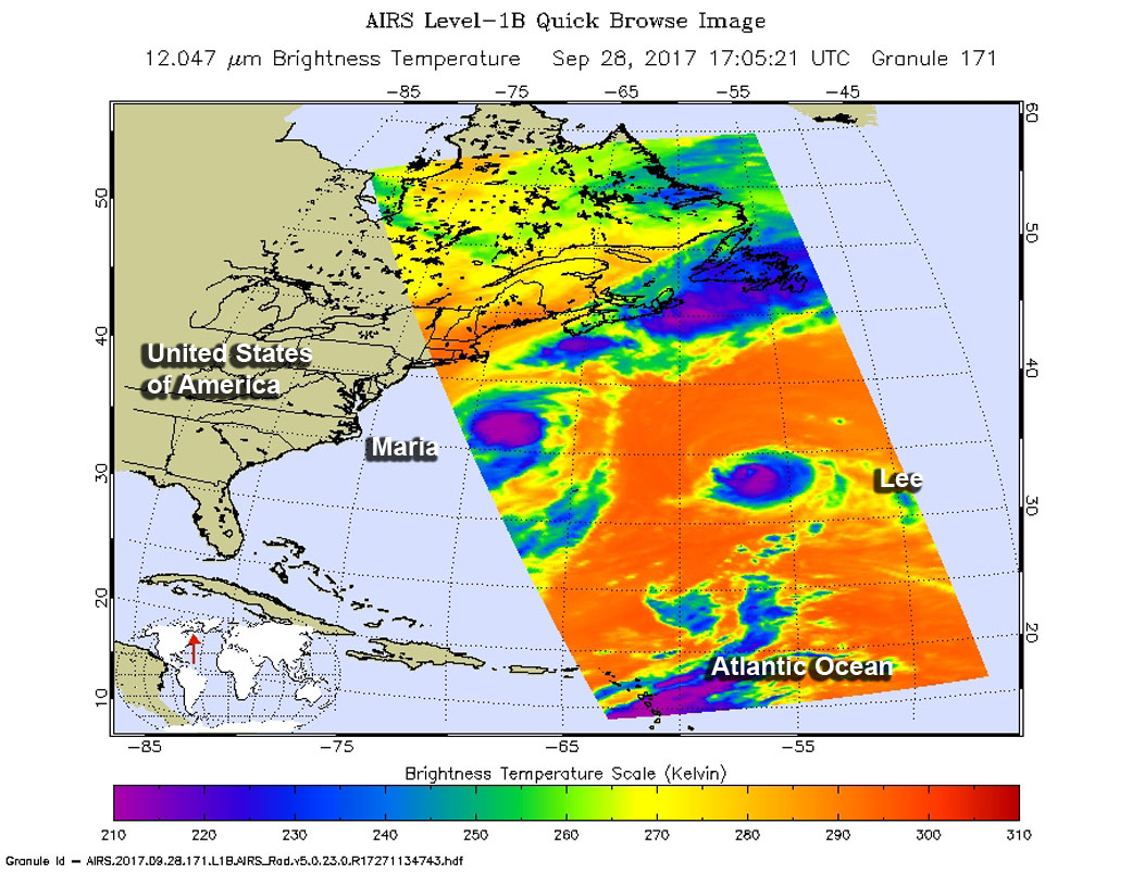
The AIRS instrument aboard NASA’s Aqua satellite captured infrared data on Hurricane Lee and Tropical Storm Maria on Sept. 28 at 1:05 p.m. EDT (17:05 UTC). The infrared data was showing the strongest storms being pushed southeast of the eye.
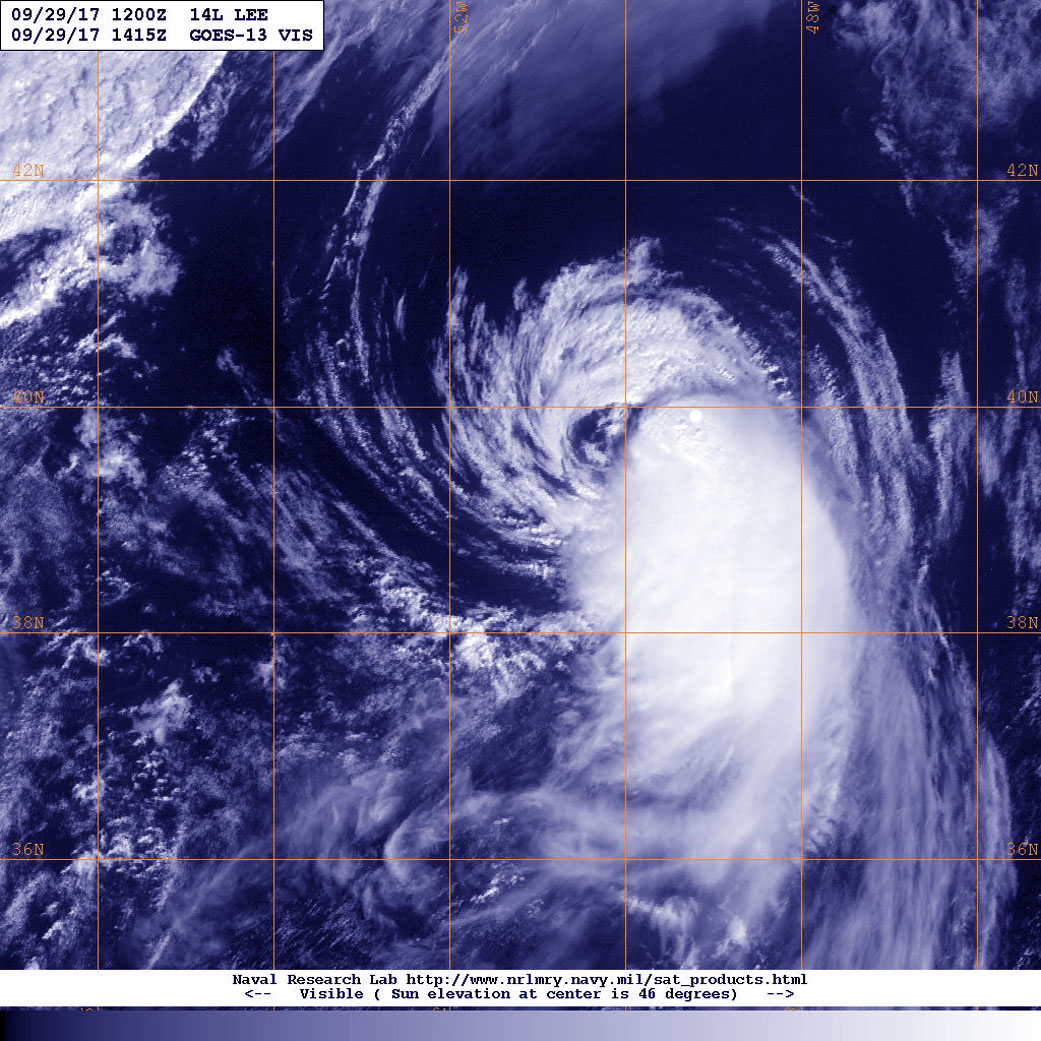
In a visible image from NOAA’s GOES East satellite on Sept. 29 at 10:15 a.m. EDT (1415 UTC), wind shear’s effect on the storm is evident. The National Hurricane Center said “Lee’s low-level center is partially exposed along the northern edge of the convective canopy due to almost 40 knots of northerly shear.“ The image shows that the bulk of clouds associated with the hurricane have been pushed to the south and southeast of the eye.
At 5 a.m. EDT/AST (0900 UTC) on Sept. 29 the National Hurricane Center reported that the center of Hurricane Lee was located near 38.3 degrees north latitude and 52.4 degrees west longitude. That’s about 810 miles (1,305 km) northeast of Bermuda. Lee was moving toward the northeast near 25 mph (41 kph). An acceleration toward the northeast is forecast to continue through Saturday.
NHC said “Maximum sustained winds have decreased to near 75 mph (120 kph) with higher gusts. Additional weakening is forecast, and Lee is expected to become a tropical storm later today. Lee will then dissipate by Saturday. Hurricane-force winds extend outward up to 40 miles (65 km) from the center, and tropical-storm-force winds extend outward up to 140 miles (220 km). The estimated minimum central pressure is 987 millibars.”
NHC noted that global computer model guidance indicate Lee will dissipate in the fast flow ahead of an approaching cold front by 36 hours (on Sept.30 by 5 a.m. EDT). NHC said “Even after Lee’s circulation opens up, a swath of strong winds will likely continue eastward toward Ireland and the United Kingdom by days 2 and 3.”
The U.K. Meteorological Office issued a yellow National Severe Weather Warning for rain and wind, highlighting parts of Wales, northwest England and southwest and central Scotland as most at risk of seeing some impacts from the weather during Saturday night into Sunday, Oct. 1. For updates on U.K. Warnings, visit: https://www.metoffice.gov.uk/public/weather/warnings
By Rob Gutro
NASA’s Goddard Space Flight Center
Sep. 28, 2017 – NASA Finds Hurricane Lee’s Strength Shift
Hurricane Lee began weakening as NASA’s Aqua satellite passed overhead and collected temperature information. Satellite data showed that Lee’s strongest side was south of its center.
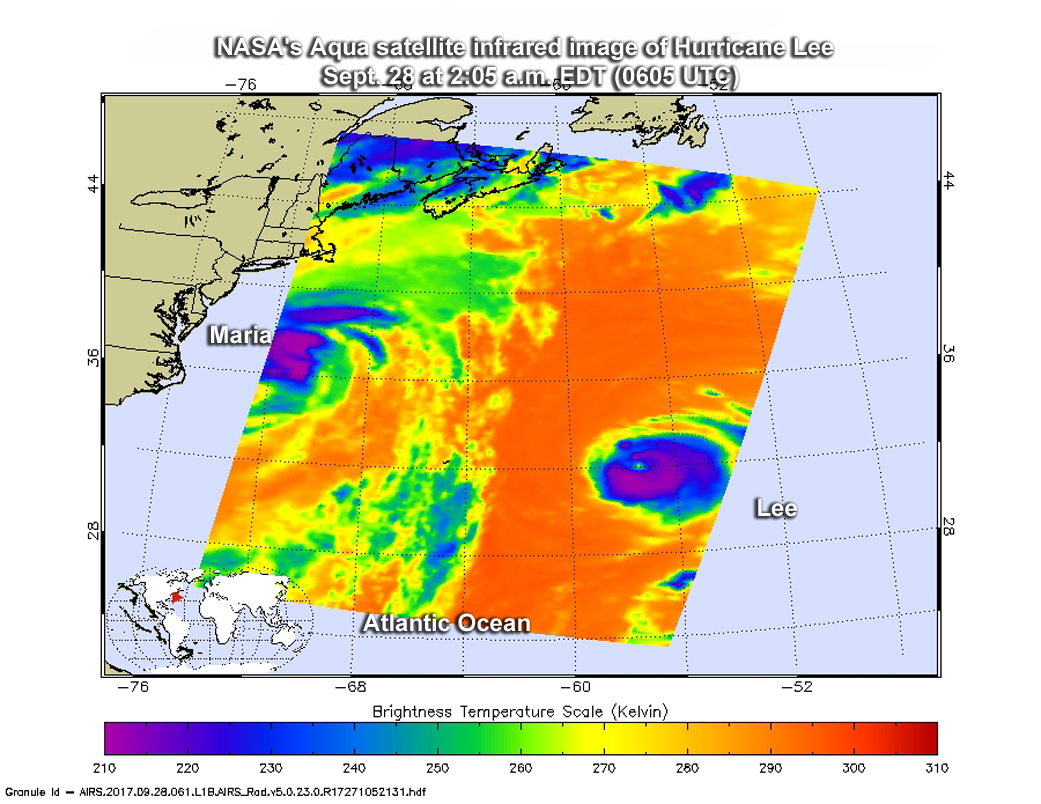
The Atmospheric Infrared Sounder or AIRS instrument aboard NASA’s Aqua satellite passed over Hurricane Lee on Sept. 28 at 2:05 a.m. EDT (0605 UTC) and analyzed the storm in infrared light. Infrared light provides temperature data and that’s important when trying to understand how strong storms can be. The higher the cloud tops, the colder and the stronger they are.
When Aqua passed over Lee, the AIRS instrument found coldest cloud top temperatures in thunderstorms mostly south of the center. Those temperatures were as cold as minus 63 degrees Fahrenheit (minus 53 degrees Celsius). Storms with cloud top temperatures that cold have the capability to produce heavy rainfall.
On Sept. 26, the National Hurricane Center (NHC) noted that “northerly shear continues to adversely affect the organization of Lee. The central dense overcast has become fairly asymmetric, with most of the cold cloud tops limited to the southern semicircle, and the eye is also losing definition.”
Lee is in the Central Atlantic Ocean and far from land areas so there are no watches or warnings in effect. At 11 a.m. EDT (1500 UTC) on Sept. 28, Lee was about 460 miles (745 km) east-northeast of Bermuda, near 33.7 degrees north latitude and 57.0 degrees west longitude. The estimated minimum central pressure is 973 millibars.
Lee was moving toward the north near 12 mph (19 kph) and NHC noted “a turn toward the northeast with an increase in forward speed is expected today and tomorrow morning. The hurricane is forecast to continue accelerating toward the northeast after that.”
Lee’s maximum sustained winds peaked at 115 mph on Sept. 27. Maximum sustained winds had decreased to near 100 mph (155 kph) with higher gusts. Continued weakening is expected and Lee is forecast to become a tropical storm on Friday, Sept. 29 as wind shear increases and the storm moves over cooler waters.
For updated forecasts on Lee, visit: www.nhc.noaa.gov.
By Rob Gutro
NASA’s Goddard Space Flight Center
Sep. 27, 2017 – Satellite Spots a Tiny, Mighty Hurricane Lee
Hurricane Lee continues to strengthen in the Central Atlantic Ocean, and the tiny hurricane appeared well-organized with a clear eye in satellite imagery.
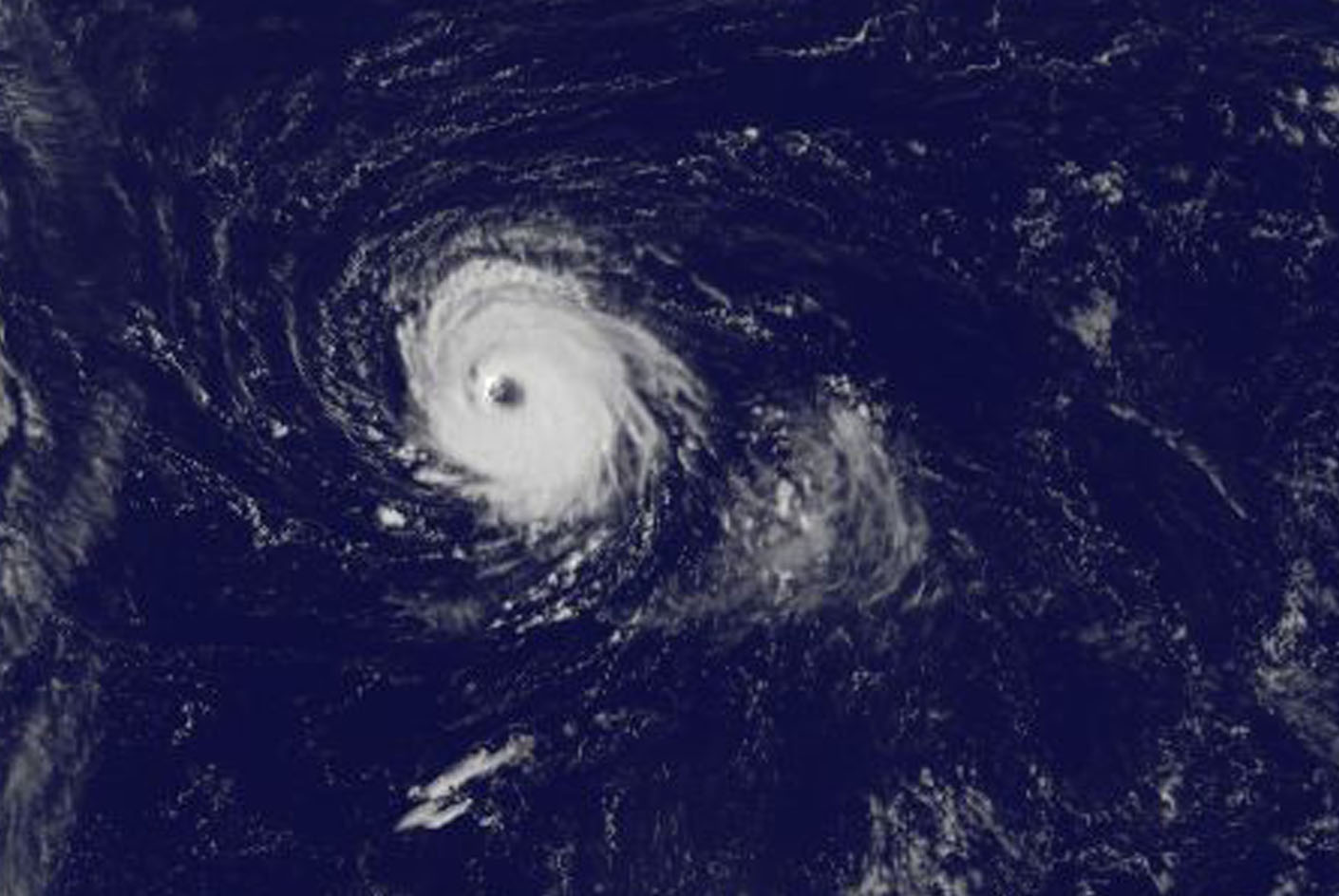
NOAA’s GOES East satellite captured this visible image of tiny Hurricane Lee in the Central Atlantic Ocean on Sept. 27 at 7:45 a.m. EDT (1145 UTC). The National Hurricane Center (NHC) noted that “Conventional satellite imagery indicates that Lee has been undergoing some cloud structural changes during the past several hours. The eye has nearly doubled in size to 30 miles in diameter.” Hurricane-force winds extend outward up to 30 miles (45 km) from the center, and tropical-storm-force winds extend outward up to 60 miles (95 km).
NOAA manages the GOES series of satellites and the NASA/NOAA GOES Project at NASA’s Goddard Space Flight Center in Greenbelt, Md. uses the satellite data to create images and animations.
At 5 a.m. EDT (0900 UTC) on Sept. 27, the center of Hurricane Lee was located near 30.2 degrees north latitude and 56.3 degrees west longitude. That’s about 520 miles (840 km) east-southeast of Bermuda. Lee was moving toward the west-northwest near 9 mph (15 kph). The hurricane is expected to turn northwestward on Wednesday and northward on Thursday, Sept. 28.
Maximum sustained winds are near 110 mph (175 kph) with higher gusts. Lee still could become a major hurricane later today before weakening commences on Thursday. The estimated minimum central pressure is 971 millibars.
For forecast updates on Lee, visit: www.nhc.noaa.gov
By Rob Gutro
NASA’s Goddard Space Flight Center
Sep. 26, 2017 – NASA Satellite Temperatures Reveal a Stronger Hurricane Lee
NASA’s Aqua satellite peered into Hurricane Lee with infrared light to determine if the storm was intensifying. Infrared data showed cloud top temperatures were getting colder, indicating stronger storms.
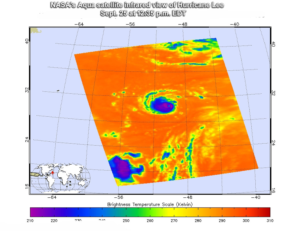
The Atmospheric Infrared Sounder or AIRS instrument aboard NASA’s Aqua satellite passed over Hurricane Lee on Sept.25 at 12:35 p.m. EDT (1635 UTC) and analyzed the storm in infrared light. Infrared light provides scientists with temperature data and that’s important when trying to understand how strong storms can be. The higher the cloud tops, the colder and the stronger they are. So infrared light as that gathered by the AIRS instrument can identify the strongest sides of a tropical cyclone.
At the time Aqua passed overhead, the eye was clear in infrared imagery, and the northwestern side of the storm had a larger area of thunderstorms than the eastern quadrant, suggestive of southeasterly wind shear. Cloud top temperatures in thunderstorms around the eyewall as cold as minus 63 degrees Fahrenheit (minus 53 degrees Celsius). Storms with cloud top temperatures that cold have the capability to produce heavy rainfall.
On Sept. 26, the National Hurricane Center noted that Lee’s cloud pattern has continued to become better organized. The eye has cleared out and has warmed to nearly 10 degrees Celsius, and the eye wall cloud tops have cooled to minus 81.4 degrees Fahrenheit (minus 63 degrees Celsius).
At 5 a.m. EDT/AST (0900 UTC) Sept. 26 the center of Hurricane Lee was located near 30.0 degrees north latitude and 52.5 degrees west longitude. That’s about 745 miles (1,195 km) east of Bermuda
Lee was moving toward the west near 10 mph (17 kph). Maximum sustained winds are near 100 mph (155 kph) with higher gusts. Some strengthening is expected over the next 24 hours or so. The estimated minimum central pressure is 977 millibars.
The National Hurricane Center forecast calls for a turn toward the west-northwest with some decrease in forward speed early Wednesday, Sept. 27, followed by a turn northwestward by Wednesday evening. Lee is forecast to turn northward and gradually increase in forward speed on Thursday.
For forecast updates on Hurricane Lee, visit: www.nhc.noaa.gov
More information about AIRS can be found at airs.jpl.nasa.gov
By Rob Gutro
NASA’s Goddard Space Flight Center
Sep. 25, 2017 – Lee Reborn as a Tiny Zombie Hurricane in Central Atlantic
Former Tropical Storm Lee was almost forgotten when Hurricanes Irma, Jose and Maria struck the U.S. because it weakened to a remnant low pressure area and lingered quietly in the Central Atlantic. On Friday, Sept. 22, however, it consolidated, organized and was reborn as a tropical storm. As Lee strengthened into a small “zombie” hurricane, NASA’s Terra and Aqua satellites analyzed the newest Atlantic Ocean hurricane.

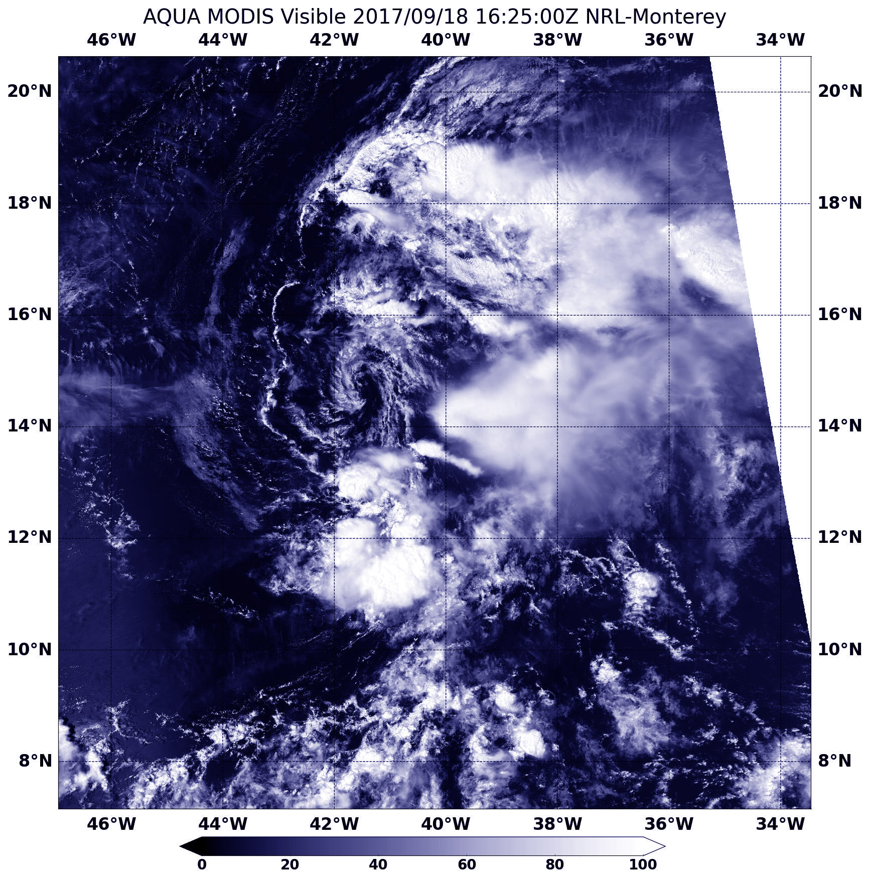
The Moderate Resolution Imaging Spectroradiometer or MODIS instrument that flies aboard NASA’s Terra satellite captured a visible picture of Hurricane Lee on Sept. 24 at 1:40 p.m. EDT (1740 UTC). When Terra passed overhead the satellite could see down to the ocean’s surface in the small, clear eye of the storm. The compact storm was surrounded by a ring of strong thunderstorms.
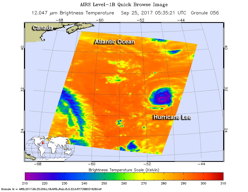
Those storms around the eye were analyzed the next day by the Atmospheric Infrared Sounder or AIRS instrument aboard NASA’s Aqua satellite on Sept. 25 at 4:53 a.m. EDT (0853 UTC). AIRS measured cloud top temperatures with infrared light. The data showed some strong thunderstorms as cold as or colder than minus 63 degrees Fahrenheit (minus 53 Celsius) in the cloud tops. NASA research has shown that storms with cloud tops that cold have the ability to produce heavy rainfall.
The National Hurricane Center (NHC) said at 11 a.m. EDT (1500 UTC), the center of Hurricane Lee was located near 30.8 degrees north latitude 30.8 North and 49.9 degrees west longitude. That’s about 880 miles (1,420 km) east of Bermuda. Lee was moving toward the south-southwest near 2 mph (4 kph).The estimated minimum central pressure is 980 millibars.
Maximum sustained winds are near 90 mph (150 kph) with higher gusts. Little change in strength is forecast during the next 48 hours. Lee is a tiny hurricane. Hurricane-force winds extend outward up to 10 miles (20 km) from the center and tropical-storm-force winds extend outward up to 35 miles (55 km).
Lee is expected to move to the west and then curve to the northeast by Thursday, Sept. 28 and continue over open ocean waters in that direction.
For forecast updates on Lee, visit the National Hurricane Center website: www.nhc.noaa.gov.
By Rob Gutro
NASA’s Goddard Space Flight Center
Sep. 18, 2017 – NASA Identifies Wind Shear Affecting Tropical Depression Lee
Visible imagery from NASA’s Aqua satellite showed Tropical Depression Lee as a weak swirl of clouds around its center with most of its clouds and thunderstorms pushed east of its center.
On Sept. 18 at 1225 p.m. EDT (1625 UTC) the Moderate Resolution Imaging Spectroradiometer or MODIS instrument aboard NASA’s Aqua satellite provided an visible image of Tropical Depression Lee. Those thunderstorms east of the center developed during the morning hours and were pushed east of the center from strong westerly to northwesterly vertical wind shear.
The National Hurricane Center discussion noted “After being nearly devoid of thunderstorm activity overnight, a burst of deep convection has developed near and to the east of the center this morning.”
At 11 a.m. EDT (1500 UTC) the center of Tropical Depression Lee was located near 14.1 degrees north latitude and 40.6 degrees west longitude. That’s about 1,115 miles (1,795 km) west of the Cabo Verde Islands. The depression is moving toward the west-northwest near 14 mph (22 kph). A turn to the northwest with a decrease in forward speed is expected to occur tonight. Maximum sustained winds remain near 35 mph (55 kph) with higher gusts. Weakening is expected, and Lee is forecast to degenerate into a remnant low on Tuesday, Sept. 19.
NHC Forecaster Cangialosi noted” Lee is expected to be embedded within very strong westerly to northwesterly shear during the next couple of days. These hostile winds, combined with a dry environment, should cause Lee to weaken and become a remnant low in about 24 hours.”
For updated forecasts on Lee, visit: www.nhc.noaa.gov.
By Rob Gutro
NASA’s Goddard Space Flight Center