


On Sept. 8, NASA’s OSIRIS-REx spacecraft is scheduled to launch for terra incognita: the unknown surface of the near-Earth asteroid Bennu. Like expeditions of old, OSIRIS-REx’s mission includes mapping the exotic terrain it explores.
Bennu is part of the debris left over from the formation of the solar system and is pristine enough to hold clues to that very early history. OSIRIS-REx – which stands for Origins, Spectral Interpretation, Resource Identification, Security-Regolith Explorer – will study Bennu in detail and collect a sample to send to Earth for in-depth analysis. The mission also will investigate how pressure from sunlight influences the path of this traveling asteroid.
“I like to say the first thing any explorer does upon reaching a new land is to start making maps,” said Ed Beshore, deputy principal investigator of OSIRIS-REx at the University of Arizona in Tucson.
For OSIRIS-REx, mapping is mission-critical. It’s one of the primary science goals and an integral part of spacecraft operations. The spacecraft will spend a year flying in close proximity to Bennu – its five instruments imaging the asteroid, documenting its lumpy shape, and surveying its chemical and physical properties.
This information will be used to produce four top-level maps for identifying the site where sample will be collected. These maps will indicate which sites are scientifically most valuable, where the spacecraft can touch the asteroid safely, where navigation can deliver the spacecraft, and where there is enough loose rock that can be collected.
About a dozen potential sampling sites will be chosen to start. Once this list has been winnowed down, reconnaissance maps will provide detailed views of the few remaining candidates. Later, after the sampling is done, the team will refine some maps to provide context for laboratory analysis of the material and to aid future studies of asteroids.
“Each map will pull together different kinds of data to answer an independent question,” said Lucy Lim, OSIRIS-REx assistant project scientist at NASA’s Goddard Space Flight Center in Greenbelt, Maryland.
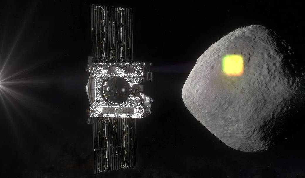
One top-level map will deal with the safety of the spacecraft. The team has to make sure OSIRIS-REx won’t encounter hazards as it approaches Bennu and executes its touch-and-go – or TAG – maneuver. A mechanical arm that functions like a pogo stick will be extended from the spacecraft. The spacecraft will slowly approach the asteroid until the sample head at the end of the arm “kisses” the surface. Then, OSIRIS-REx will move away from the asteroid.
The target area for TAG will be a circle that measures 164 feet (50 meters) across.
“We have to be able to say with a high degree of confidence that the spacecraft will be safe if it touches the surface anywhere within that circle,” said David Lorenz, OSIRIS-REx TAG lead at Goddard.
To determine that, the team will look at the tilt of the landscape, temperature readings, and whether plumes of material are coming off the asteroid. Another consideration will be the amount of light reflected by the surface. That’s important because OSIRIS-REx will bounce laser signals off the surface. If an area is too dark, there won’t be enough return signal; an area that’s too bright will blind the detector.
Hazards such as large boulders and steep cliffs will be identified at a different stage.
Another top-level map will address the ability to deliver OSIRIS-REx to its target. This is primarily a navigation question: Can the spacecraft be brought to a target site at the correct speed? (Both vertical speed and sideways speed matter.) If not, the spacecraft will be in danger of crashing or tipping over in a so-called stubbed-toe scenario.
Bennu’s mass makes navigating a particular challenge. The asteroid will be one of the smallest objects ever visited by a planetary spacecraft. Bennu has very little gravity – so little that pressure from sunlight on OSIRIS-REx will almost equal the force of Bennu’s gravity. To stay in orbit, the spacecraft will have to remain within a mile and a half (about 2.4 kilometers) of Bennu. Any farther than that, and the pressure from sunlight will push it away from the asteroid.
“The bottom line is that we’re paying a lot more attention to modeling very small accelerations, such as those exerted by solar radiation pressure, than previous missions have had to do,” said Michael Moreau, OSIRIS-REx flight dynamics system manager at Goddard.
The third of these maps will determine where the right kind of surface material is located. The sample head, which looks like a big automotive air filter, can take in dirt, dust and bits of gravel measuring less than three-fourths of an inch (2 centimeters). At least 2 ounces (60 grams) of material needs to be collected, but the sample head can hold up to 4.4 pounds (2 kilograms).
“Our goal is to maximize the amount of sample for OSIRIS-REx,” said Kevin Walsh, an OSIRIS-REx co-investigator at the Southwest Research Institute in Boulder, Colorado. “We have tested the sample head in the lab and know how it performs, and we will hunt for the right sort of environment on Bennu.”
To find that, the team will look at images, tilt measurements and thermal information, which reveals how the material on the surface stores and releases heat. Coarser, rockier grains will absorb more heat from the sun and give it off slowly during the asteroid’s night. Fine-grained particles will lose heat very quickly once they are out of the sunlight.
The fourth top-level map will evaluate the scientific value of the surface on Bennu. From remote observations, the team assumes that Bennu should contain water and organic – or carbon-rich – material, but they don’t know yet how this material is distributed across the surface.
“Some of the most interesting sites will be those that offer fresh material – perhaps exposed by an impact, a crack or plume activity like comets have – and those with diverse material,” said Keiko Nakamura-Messenger, OSIRIS-REx sample site scientist and the deputy lead for curation at NASA’s Johnson Space Center in Houston. “We also believe the coldest place has higher science value, because that is where organics are likely to be better preserved.”
To figure this out, the team will look at geological features, mineralogy, chemical composition and temperature.
All of these maps will be built on a 3-D shape model of Bennu. The team is already using a preliminary shape model, produced from radar observations of the asteroid. But a new shape model with much higher resolution will be made once OSIRIS-REx surveys Bennu.
“The shape model is the framework – the one piece every map needs to have,” said Eric Palmer, an OSIRIS-REx collaborator at the Planetary Science Institute in Tucson. “It also provides a way of correcting scientific observations so that you can make apples-to-apples comparisons.”
The team has two ways of deriving the detailed shape of Bennu. One is to make precise measurements of the round-trip distance from the spacecraft to the asteroid using the on-board laser altimeter. The other is the so-called shape-by-shading technique – or stereophotoclinometry – which deduces the 3-D lay of the land from multiple images taken from different angles under a range of lighting conditions.
Beshore pointed out one more reason to put all this effort into mapping. “These maps of Bennu are going to be beautiful,” he said.
NASA Goddard Space Flight Center in Greenbelt, Maryland, provides overall mission management, systems engineering and safety and mission assurance for OSIRIS-REx. Dante Lauretta is the mission’s principal investigator at the University of Arizona, Tucson. Lockheed Martin Space Systems in Denver is building the spacecraft. OSIRIS-REx is the third mission in NASA’s New Frontiers Program. NASA Marshall Space Flight Center in Huntsville, Alabama, manages New Frontiers for the agency’s Science Mission Directorate in Washington.
Launch management is the responsibility of NASA’s Launch Services Program at the Kennedy Space Center in Florida.
For more information on OSIRIS-REx visit:
and