![Request for Information – Potential [Placeholder for Prize]](https://assets.science.nasa.gov/dynamicimage/assets/science/psd/solar/2023/09/s/solarsystem_0.jpg?w=1024)


NASA operates two Lockheed ER-2 Earth Resources aircraft as flying laboratories in the Airborne Science Program under the Agency’s Science Mission Directorate. The aircraft are based at NASA’s Armstrong Flight Research Center Building 703 in Palmdale, California, and collect information about the Earth’s resources, celestial observations, atmospheric chemistry and dynamics, and oceanic processes. The aircraft are also used for electronic sensor research and development, satellite calibration, and satellite data validation.
Program History
NASA acquired its first ER-2 aircraft in 1981 and the second in 1989. They replaced two Lockheed U-2 aircraft that NASA was using since 1971 to collect science data. The U-2s, and later the ER-2s, were based at NASA’s Ames Research Center in Moffett Field, California, until 1997, when the ER-2s and their operations moved to NASA Armstrong.
Since the Airborne Science Program’s inaugural flight on Aug. 31, 1971, NASA U-2s and ER-2s have flown more than 4,500 data missions and test flights in support of scientific research.
NASA’s ER-2 set a world record for reaching an extreme altitude for this class of aircraft with a takeoff weight between 26,455 and 35,275 pounds on Nov. 19, 1998. The aircraft reached 68,700 feet.
Atmospheric Experiments
NASA’s ER-2s are an invaluable tool for studying lower stratosphere and the North American Monsoon Anticyclone (NAMA). During the summers of 2021 and 2022, the Dynamics and Chemistry of the Summer Stratosphere (DCOTSS) mission based in Salina, Kansas, carried 12 instruments aboard that took in situ measurements of important trace gases, aerosols, reactive species, and meteorological parameters.
The measurements collected from DCOTSS helped scientists understand how strong convective systems penetrate the lowest layer of the stratosphere, also called the tropopause, with large-scale monsoonal motion, and the impact of that convection on the chemical composition of the lower stratosphere. During each flight that collected convection samples, the ER-2 executed several vertical profiles as well as level transects through convective outflow to fully characterize the plume as well as the surrounding background air. This campaign provided a better understanding on how these dynamic and chemical processes interact within the composition of the stratosphere, and how that composition may change in response to ongoing changes in the climate system.
During a three-year campaign, the ER-2 spent winters in the Southeast U.S. to study snowfall. Snowstorms frequently organize in banded structures that have previously been poorly understood by scientists and poorly predicted by current numerical models. Since the last study on snowstorms, the capabilities of remote sensing technologies and numerical weather prediction models have advanced significantly. Due to this advancement, it is an ideal time to conduct a well-equipped study to identify key processes and improve remote sensing and forecasting of snowfall.
For this campaign, Investigation of Microphysics and Precipitation for Atlantic Coast-Threatening Snowstorms (IMPACTS), the ER-2 and NASA’s P-3 aircraft based out of Wallops Island, Virginia, fly a complementary suite of remote sensing and in-situ instruments to address specific objectives, providing observations critical to understanding the mechanisms of snow band formation, organization, and evolution.
Satellite Sensor Development
Since the Airborne Science Program’s inception, NASA U-2s and ER-2s have assisted in developing new satellite sensors by testing prototypes or by simulating proposed configurations with existing systems.
The ER-2 carries the Airborne Visible Infrared Imaging Spectrometer (AVIRIS), a 224-band hyper-spectral scanner designed by NASA’s Jet Propulsion Laboratory in Pasadena, California. The main objective of the AVIRIS project is to identify, measure, and monitor constituents of the Earth’s surface and atmosphere based on molecular absorption and particle scattering signatures. Research with AVIRIS data is predominantly focused on understanding processes related to the global environment and climate change.
Another instrument, Airborne Lunar Spectral Irradiance (Air- LUSI), makes highly accurate, traceable measurements of lunar spectral irradiance. These measurements can be used to validate or adjust current models of lunar spectral irradiance used for calibrating Earth observing satellites. Air-LUSI is initially being used to address the current 5to10 percent uncertainty range of exo-atmospheric spectral lunar irradiance. Improved lunar spectral irradiance model accuracy will help satellite instruments use the Moon as an absolute calibration reference, greatly improving the versatility and speed of on-orbit satellite calibration.
Deployments
NASA’s ER-2s have deployed to six continents, investigated global warming and ozone depletion, and acquired extensive digital multispectral imagery for global climate change research and aerial photography. These missions tested prototype satellite imaging sensors and acquired Earth resources data for research projects sponsored by NASA and federal agencies such as the U.S. Forest Service, Environmental Protection Agency, U.S. Fish and Wildlife Service, and the U.S. Army Corps of Engineers.
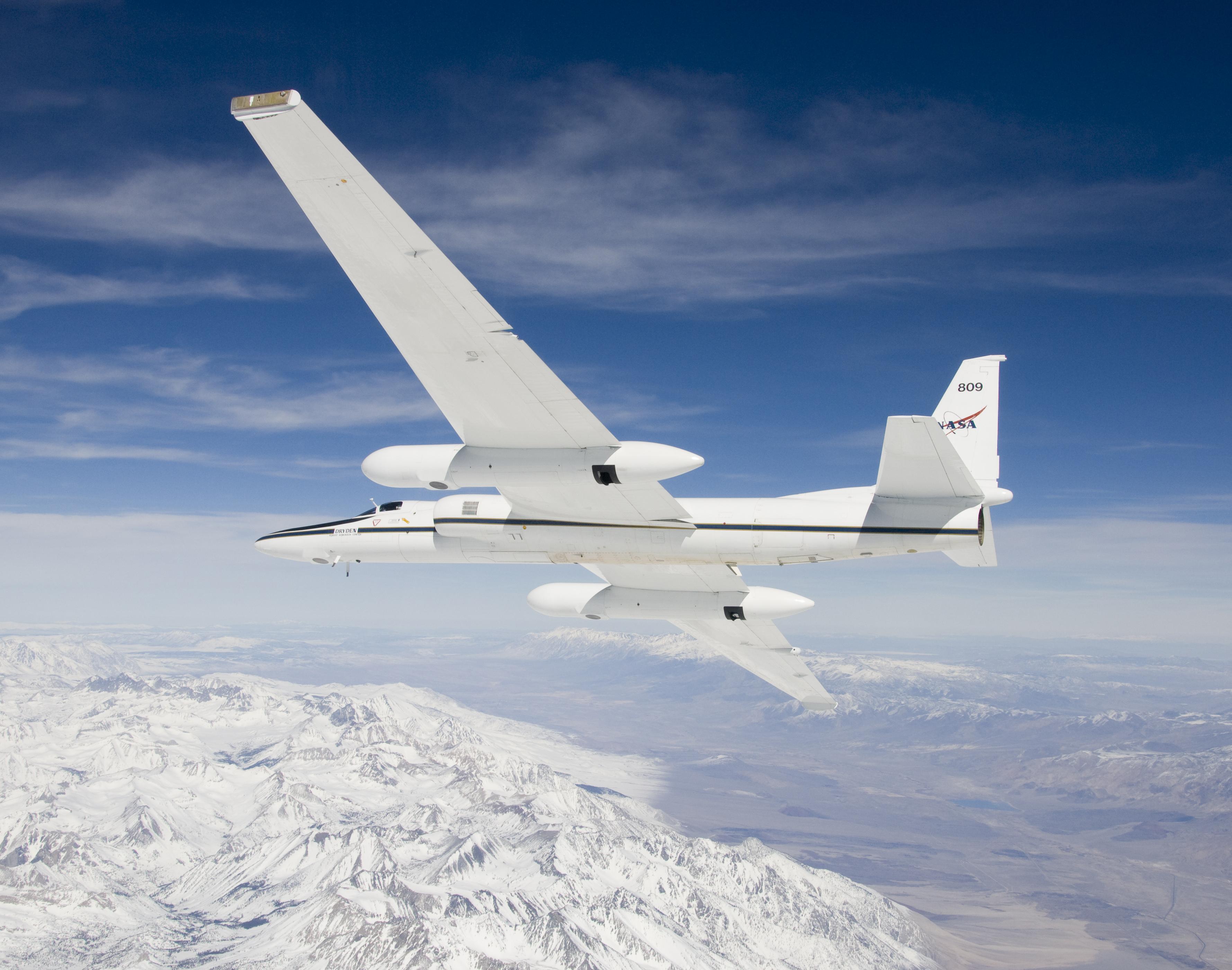
Aircraft Description
The ER-2 is a versatile aircraft well suited to perform multiple mission tasks.
The ER-2 operates at altitudes from 20,000 feet to 70,000 feet, which is above 99 percent of the Earth’s atmosphere. Depending on aircraft weight, the ER-2 reaches an initial cruise altitude of 65,000 feet within 20 minutes. Typical cruise speed is 410 knots. The range for a normal eight-hour mission is 3,000 nautical miles, yielding seven hours of data collection at altitude. The aircraft is capable of longer missions, more than 10 hours long, and ranges more than 6,000 nautical miles. The ER-2 can carry a maximum payload of 2,600 pounds (1,179 kilograms) distributed in the equipment bay, nose area, and wing pods.
The aircraft has four large, pressurized experiment compartments and a high-capacity AC/DC electrical system, permitting it to carry a variety of payloads on a single mission. The modular design of the aircraft permits rapid installation or removal of payloads to meet changing mission requirements.