


![Request for Information – Potential [Placeholder for Prize]](https://assets.science.nasa.gov/dynamicimage/assets/science/missions/a-step/FFR_Earth_Background_20251120%20.png?w=1024)


NASA Sees Tropical Storm Rick Become a Post-Tropical Low
The remnants of post-tropical cyclone Rick continued to linger in the Eastern Pacific Ocean on November 23. An animation of visible and infrared imagery from NOAA’s GOES-West satellite showed the weakening of Tropical Storm Rick into a remnant low pressure area from Nov. 21 to Nov. 23 in the Eastern Pacific Ocean, far off-shore from western Mexico. NASA’s RapidScat instrument spotted the remnant’s strongest winds on its eastern side on Nov. 22.
Credits: NASA/NOAA GOES Project
Imagery from NOAA’s GOES-West satellite were compiled into an animation at NASA’s Goddard Space Flight Center in Greenbelt, Maryland. As the storm progressed northward, parallel to the coast of western Mexico, the development of thunderstorms had diminished over the three days.
The RapidScat instrument that flies aboard the International Space Station analyzed post-tropical cyclone Rick’s surface winds on Nov. 22 at 11 a.m. EST (1600 UTC). RapidScat saw the strongest winds were near 15 meters per second (33.5 mph/54 kph) east of the center. Winds on the western side of the storm were only between 6 and 12 meters per second (13.4 and 26.8 mph/21.6 and 43 kph).
The National Hurricane Center issued the final bulletin on Tropical Cyclone Rick at 4 p.m. EST (1 p.m. PST/2100 UTC) on Nov. 22. At that time the center of Post-Tropical Cyclone Rick was located near latitude 18.1 north, longitude 119.1 west. That’s about 680 miles (1,095 km) west-southwest of the southern tip of Baja California. The low was moving toward the northwest near 8 mph (13 kph). A turn north is expected. Maximum sustained winds were near 35 mph (55 kph) and the remnant low is expected to dissipate in a few days.
On Monday, Nov. 23, Rick’s post-tropical remnant low pressure area was near 19 degrees north latitude and 120 degrees west longitude. The remnant low had a minimum central pressure near 1007 millibars. Maximum sustained winds were near 20 knots (23 mph/37 kph) in the northeastern and southwestern quadrants.
For additional information on the remnant low please see High Seas Forecasts issued by the National Weather Service, under AWIPS header NFDHSFEPI, WMO header FZPN01 KWBC, and on the web at http://www.opc.ncep.noaa.gov/shtml/NFDHSFEP1.shtml.
Rob Gutro
NASA’s Goddard Space Flight Center
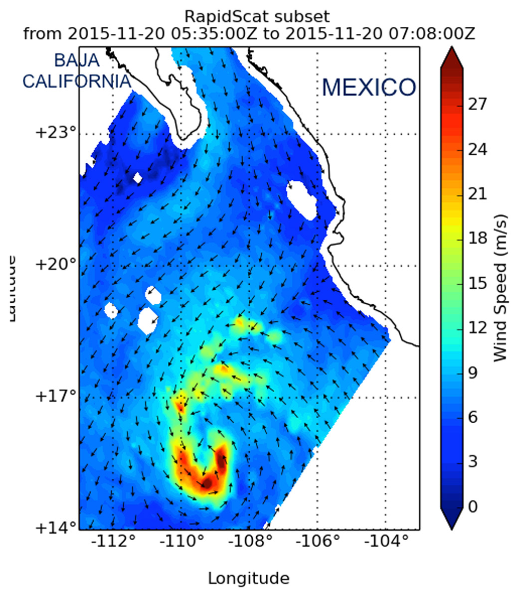
Nov. 20, 2015 – NASA’s Aqua Satellite Eyes Tropical Storm Rick in Eastern Pacific
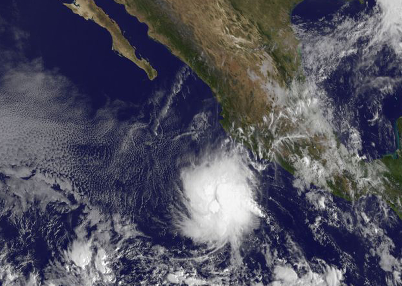
NASA’s Aqua satellite passed over Rick and captured a visible light image that showed the storm far off the coast of western Mexico. Rick continued to hang on to its status as tropical storm on Nov. 20, although a minimal one.

The MODIS instrument aboard NASA’s Aqua satellite captured a visible image of Tropical Storm Rick on Nov. 19 at 20:15 UTC (3:15 p.m. EST). The image showed thunderstorms circling the low-level center, and a larger band of thunderstorms feeding into the center from the northeast.
Forecaster Berg of the National Hurricane Center said that banding of thunderstorms appears better defined on Friday, Nov. 20. Recent scatterometer data, which measures surface winds, indicate that the maximum winds remain about 35 knots (40 mph), with the tropical-storm-force winds confined to a small area west of the center.
At 4 a.m. EST (0900 UTC) on Nov. 20, the center of Tropical Storm Rick was located near latitude 15.9 North, longitude 109.4 West. That’s about 400 miles (640 km) west-southwest of Manzanillo, Mexico. Rick was moving toward the west-northwest near 13 mph (20 kph), and this general motion with a gradual decrease in forward speed is expected through Saturday night.
Maximum sustained winds remain near 40 mph (65 kph) with higher gusts. The National Hurricane Center said that little change in strength is forecast during the next 48 hours. The estimated minimum central pressure is 1002 millibars.
Rick is expected to remain far from land over the next two days and weaken to a depression by Nov. 22.
For forecast updates, visit the National Hurricane Center website at: www.nhc.noaa.gov.
Rob Gutro
NASA’s Goddard Space Flight Center
Nov. 19, 2015 – Tropical Storm Rick Joins an Elite Late-Season Storm Group
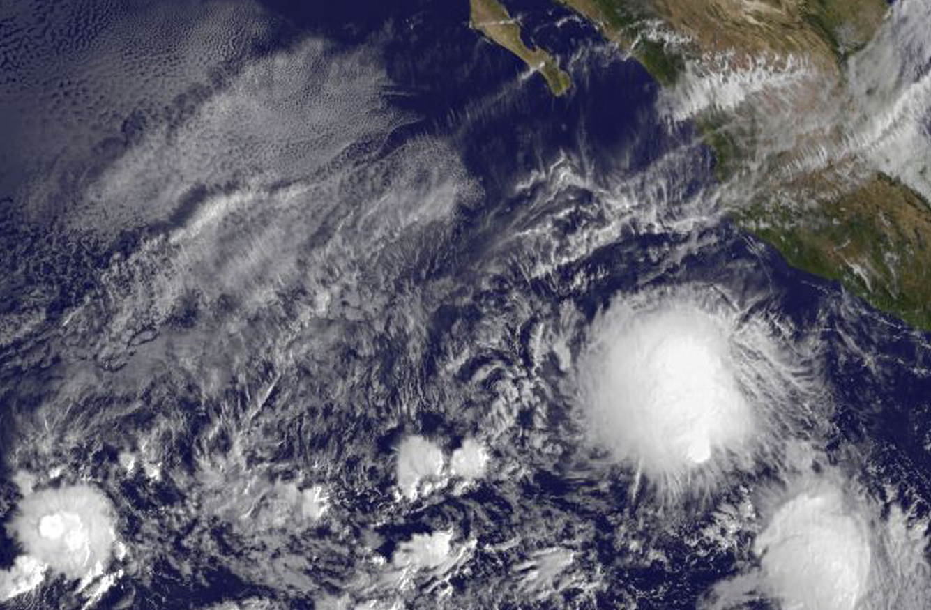
The twenty-first tropical depression of the Eastern Pacific Ocean season strengthened into a tropical storm on Nov. 19 and was renamed Tropical Storm Rick bringing the storm into a small elite group of late-season storms. NOAA’s GOES-West satellite provided an early daylight image of the storm that showed it had become more organized since it formed on Nov 18.
On Nov. 19 Rick joined an elite group of tropical cyclones. The National Hurricane Center noted that only three tropical storms have formed later than this calendar date in the eastern North Pacific since reliable records began in the early 1970s.
On Nov. 19 at 1500 UTC (10:00 a.m. EST), the NOAA’s GOES-West satellite saw the Tropical Storm southwest of the western Mexican coast. National Hurricane Center forecaster Kimberlain said “First-light (GOES-West) visible imagery indicates that the low-level center is underneath a circular mass of deep convection, and there has been an increase in banding features and their associated curvature. The increase in organization could be a sign of some decrease of the southeasterly shear that has been affecting the cyclone.”
At the time of the GOES-West image, the center of Tropical Storm Rick was located near latitude 14.7 North, longitude 105.8 West. That puts the center about 315 miles (505 km) south-southwest of Manzanillo Mexico. There are no coastal watches or warnings in effect.
Rick was moving toward the north near 7 mph (11 kph) and the National Hurricane Center expects Rick to turn toward the northwest then west-northwest by Friday, Nov. 20. The estimated minimum central pressure is 1002 millibars.Maximum sustained winds have increased to near 40 mph (65 kph) with higher gusts. Some strengthening is forecast during the next day or two.
For updated forecasts, visit: http://www.nhc.noaa.gov.
Rob Gutro
NASA’s Goddard Space Flight Center
Nov. 18, 2015 – Twenty-first Depression Forms in Eastern Pacific Ocean
NOAA’s GOES-West satellite provided images of the birth of the latest tropical depression in the Eastern Pacific Ocean. Tropical Depression 21E formed well southwest of the Coast of Mexico.
On Nov. 18 at 1500 UTC (10:00 a.m. EST), the NOAA’s GOES-West satellite saw the Tropical Depression 21E form well southwest of the western Mexican coast. The storm appeared rounded in GOES imagery, but the storm was being affected by wind shear.
Forecaster Kimberlain at the National Hurricane Center said “These data and first-light visible satellite imagery also indicate that the center of the cyclone is near the southeastern edge of large mass of cold-topped convection, suggesting the presence of some southeasterly [vertical wind] shear.”
At 11 a.m. EST (1600 UTC), the center of Tropical Depression Twenty-One-E was located near latitude 13.0 north, longitude 107.2 west. That puts the center about 455 miles (735 km) south-southwest of Manzanillo, Mexico. The estimated minimum central pressure is 1005 millibars.
The depression was moving toward the north near 2 mph (4 kph), and this general motion is expected to continue today. A turn toward the north-northwest and then northwest is expected Thursday and Friday with an increase in forward speed. Maximum sustained winds are near 35 mph (55 km/h) with higher gusts.
Some strengthening is forecast during the next 48 hours, and the depression is expected to become a tropical storm tonight or Thursday, Nov. 19.
The National Hurricane Center forecast track turns the storm away from the coast, toward the west-northwest. For updated forecasts, visit: http://www.nhc.noaa.gov.