


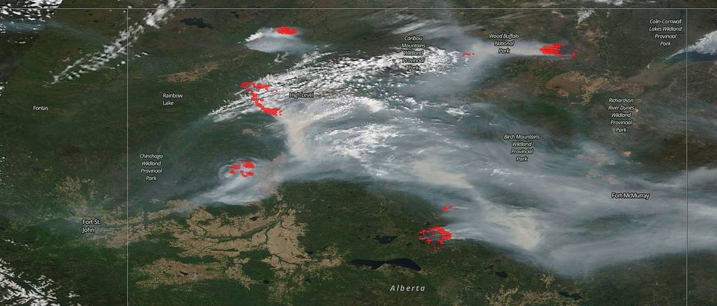
Alberta, Canada has been experiencing a very difficult fire season already which began on March 1. The entire province looks as though it is completely engulfed in smoke. There are five large areas of satellite “hot spots” that are visible in this natural-color satellite image collected by the Moderate Resolution Imaging Spectroradiometer (MODIS) aboard the Terra satellite on May 29, 2019.
The five areas are the Steen River area, the High Level area, the Peace River area, the Slave Lake area, and the Wood Buffalo National Park. All areas have been designated as fire danger at the level EXTREME with the exception of the Wood Buffalo National Park which was designated VERY HIGH.
In the Steen River area, which is to the north of High Level, has Wildfire HWF066 which is out of control and is currently at 17,419 ha (43,043 acres). McKenzie County issued a mandatory evacuation for the area.
The High Level area has the largest wildfire currently in the province of Alberta. The Chuckegg Creek Fire has been burning out of control since Sunday, May 19 when it was first reported. Currently this fire is 150,000 ha (370,658 acres). Due to extreme fire behavior and high winds out of the north northwest, the fire is growing in a south to southeast direction. The smoke from the fire has been massive and the air quality index is at dangerous levels and visibility has been reduced. Winds will continue to shift bringing smoky conditions. The air quality information was issued by Environment Canada, Alberta Environment and Parks, Alberta Health and Alberta Health Services.
The Peace River area to the south of High Level has had 70 wildfires in area this fire season, and each of these wildfires has now been extinguished with the exception of the following:
The Battle Complex fire consisting of the Notikewin and Battle River wildfires. Notikewin fire (PWF 052) is 40,553 ha (100,208 acres) in size. This fire has been extremely volatile in its fire behavior. The Battle River area fire (PWF 054) is 74 ha (182 acres) in size and is under control. PWF 070 is being held at 251 ha (620 acres) with the fire being completely surrounded by dozer guards. In this area temperatures are expected to drop to the high teens and the relative humidity is expected to climb slightly to around 25-30%. Lowering temperature and higher humidity will help firefighters, however, winds are expected to come in from the north-northeast at 20 kph (12 mph) with potential gusts up to 40 kph (25 mph). Winds allow fires to move more quickly jumping from one area to another.
The Slave Lake area also is experiencing EXTREME fire danger and its own set of wildfires. The McMillan wildfire number 49 recently experienced significant growth and the Maria Lake wildfire number 69 is expected to burn into the McMillan wildfire. With the gusty north winds today, the wildfires in the area are expected to spread. There are three new wildfires as of May 30 all east of the Maria Lake wildfire which are between 1-20 ha (2.4 – 49 acres) in size. Since the start of the wildfire season on March 1st, there have been 79 wildfires and 81,827 ha (202,198 acres) have burned in the Slave Lake Forest Area.
Parks Canada has the information regarding the Wood Buffalo National Park fires seen in the satellite image to the far northeast. This area has been designated as VERY HIGH fire danger. There are four separate fires in the national park for a total of 57,667 ha (142,498 acres) in size. The largest fire at 54,720 ha (135,216 acres) has been designated as “being managed.”
NASA’s Earth Observing System Data and Information System (EOSDIS) Worldview application provides the capability to interactively browse over 700 global, full-resolution satellite imagery layers and then download the underlying data. Many of the available imagery layers are updated within three hours of observation, essentially showing the entire Earth as it looks “right now.” Actively burning fires, detected by thermal bands, are shown as red points and when accompanied by smoke, as in this image, are indicative of fire. Image Courtesy: NASA Worldview, Earth Observing System Data and Information System (EOSDIS). Caption: Lynn Jenner with information from Alberta Wildfire and Parks Canada