


Ela (was 4E – Central Pacific)
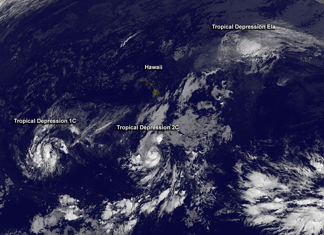
NOAA’s GOES-West satellite saw that Hawaii is in the middle of a triangle of tropical cyclones. Post-Tropical Depression Ela was located northeast of Hawaii on July 10, and the forecast calls for the storm to move west toward the islands over the weekend of July 11 and 12 and dissipate.
There are three tropical cyclones in the Central Pacific Ocean and Hawaii is in the middle of them. On July 10, newborn Tropical Depression 01C was west of Hawaii, while newborn Tropical Depression 02C was south of the Big Island. Post-Tropical Depression Ela was northeast of the islands and is the only one of the three expected to affect Hawaii.
On July 10, NOAA’s Central Pacific Hurricane Center (CPHC) noted that swells from Ela will cause high surf along east facing shores of the main Hawaiian Islands over the next several days.
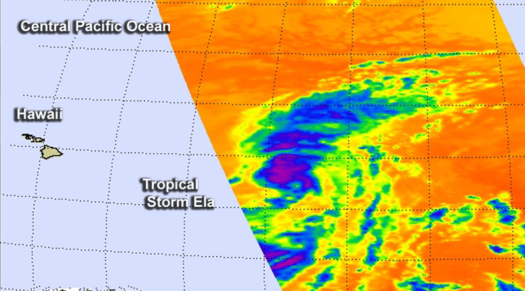
NOAA’s GOES-West satellite provided an infrared image of the depression. The depression appeared a rounded area of clouds on satellite imagery, but the stronger thunderstorms were displaced to the northeast of the center as a result of southwesterly wind shear. The University of Wisconsin Cooperative Institute for Meteorological Satellite Studies or CIMISS noted that strong southwesterly wind shear affecting the system is near 33 knots (27.9 mph/61.1 kph). The image was created from NASA/NOAA’s GOES Project at NASA’s Goddard Space Flight Center in Greenbelt, Maryland.
At 5 a.m. HST (11 a.m. EDT/1500 UTC) the center of Post-Tropical Depression Ela was located near latitude 22.0 north and longitude 149.3 west. The post-tropical cyclone was moving toward the west-northwest near 9 mph (15 kph) and this motion is expected to continue with a gradual turn toward the west. Maximum sustained winds were near 35 mph (55 kph) and weakening is forecast the next two days. The estimated minimum central pressure is 1008 millibars.
CPHC noted that “Ela will become an increasingly shallow system with the remnant low or circulation center getting caught up in the trade wind flow over the weekend.” Ela is forecast to dissipate early Sunday, July 12.
Rob Gutro
NASA’s Goddard Space Flight Center
July 09, 2015 – Tropical Storm Ela Becomes the Central Pacific’s First Named Storm
Tropical Storm Ela was born in the western-most part of the Eastern Pacific Ocean but has become the Central Pacific’s first named storm. NASA’s Aqua satellite took a look at the storm that’s already battling wind shear to survive.
After developing as a depression on July 8, Tropical Depression 4E crossed over the 140 degree West longitude line that separates the Eastern Pacific from the Central Pacific Ocean region. The depression strengthened into a tropical storm early on July 9, taking a name from the Eastern Pacific tropical cyclone list and being renamed Ela.
When NASA’s Aqua satellite passed over Ela on July 8 at 22:29 UTC (6:29 p.m. EDT), the Atmospheric Infrared Sounder or AIRS instrument measured the temperatures of the storm’s cloud tops using infrared light. That infrared data showed that wind shear from the southwest was pushing all the strongest thunderstorms with the coldest cloud tops to the northeast of the center. The AIRS data showed those thunderstorms in the northeastern quadrant had temperatures as cold as -63F/-52C. Storms that high in the troposphere, the lowest layer of Earth’s atmosphere, have the potential to drop heavy rain. Since Ela is far from land areas the rainfall occurred at sea.
On July 9, NOAA’s Central Pacific Hurricane Center (CPHC) noted that the latest satellite imagery showed “that persistent southwesterly shear has shunted the mid-level center of the cyclone well northeast of the surface center. However, data from a U.S. Air Force Hurricane Hunter aircraft indicate surface winds near 35 knots in the northeast quadrant. “
On July 9 at 5 a.m. HST (1500 UTC/11 a.m. EDT) the center of Tropical Storm Ela was located near latitude 20.2 north and longitude 146.1 west. That puts Ela’s center about 585 miles (940 km) east of Hilo, Hawaii, and about 765 miles (1,230 km) east of Honolulu, Hawaii.
Ela is moving toward the northwest near 13 mph (20 kph) and this motion is expected to continue through tonight. A turn toward the west and a slight decrease in forward speed is forecast for Friday, July 10 and Saturday, July 11. Maximum sustained winds are near 40 mph (65 kph) with higher gusts. The estimated minimum central pressure is 1003 millibars.
The outlook for Ela seems bleak because the wind shear is expected to persist on its track to the west. Ela is forecast to succumb to the shear and gradually weaken today, July 9 and July 10. Ela is expected to eventually dissipate north of Hawaii.
Rob Gutro
NASA’s Goddard Space Flight Center
July 08, 2015 – New Tropical Depression Forms and Moves into Central Pacific Ocean
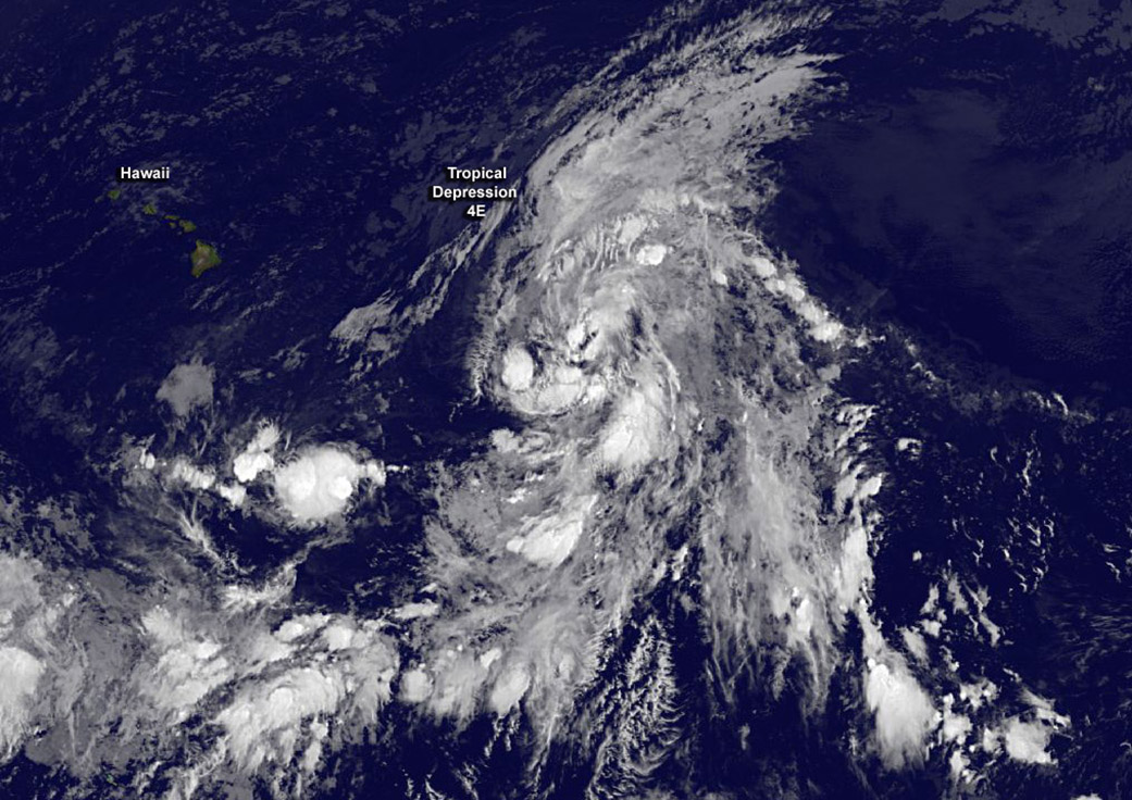
Tropical Depression 4E formed in the Eastern Pacific and crossed the 140 West longitude line as of the 0300 UTC time, which brought it into the Central Pacific Ocean. NOAA’s GOES-West satellite captured an infrared image of the depression at 0900 UTC (5 a.m. EDT) on July 8 that showed the large storm in the Central Pacific.
At 8 p.m. PDT/11 p.m. EDT on July 7, (0300 UTC on July 8), the center of newly formed Tropical Depression Four-E was located near latitude 15.4 North, longitude 140.2 West. The depression was moving toward the west-northwest near 17 mph (28 kph) and this general motion is expected to continue for the next 48 hours.
Maximum sustained winds are near 35 mph (55 kph). The National Hurricane Center noted that some strengthening is forecast during the next 48 hours, and the depression is expected to become a tropical storm later Tuesday night (July 8) or early Wednesday, July 9. The estimated minimum central pressure is 1005 millibars.
Tropical Depression 4E has now moved into the Central Pacific Ocean, and the future forecasts will be issued by NOAA’s Central Pacific Hurricane Center in Honolulu, Hawaii.
The GOES satellite image showed a large storm with fragmented bands of thunderstorms wrapping into the low level center from the north and south. The image was created by the NASA/NOAA GOES Project at NASA’s Goddard Space Flight Center, Greenbelt, Maryland.
NHC noted that in four days, the system is expected to weaken and become more vertically shallow, and be steered westward by the low-level easterly trade wind flow.
Rob Gutro
NASA’s Goddard Space Flight Center