


On May 4, 1976, NASA launched a cannonball-shaped satellite that transformed studies of Earth’s shape, rotation and gravity field.
LAGEOS – short for Laser Geodynamic Satellite – was the first NASA orbiter dedicated to the precision measurement technique called laser ranging. With it, scientists have measured the movement of Earth’s tectonic plates, detected irregularities in the rotation of the planet, weighed it, and tracked small shifts in its center of mass.
Small deviations in the satellite’s orbit were used to develop early models of Earth’s gravitational field. Further perturbations in the orbit helped explain how sunlight heating small objects can affect their orbits, including near-Earth asteroids.
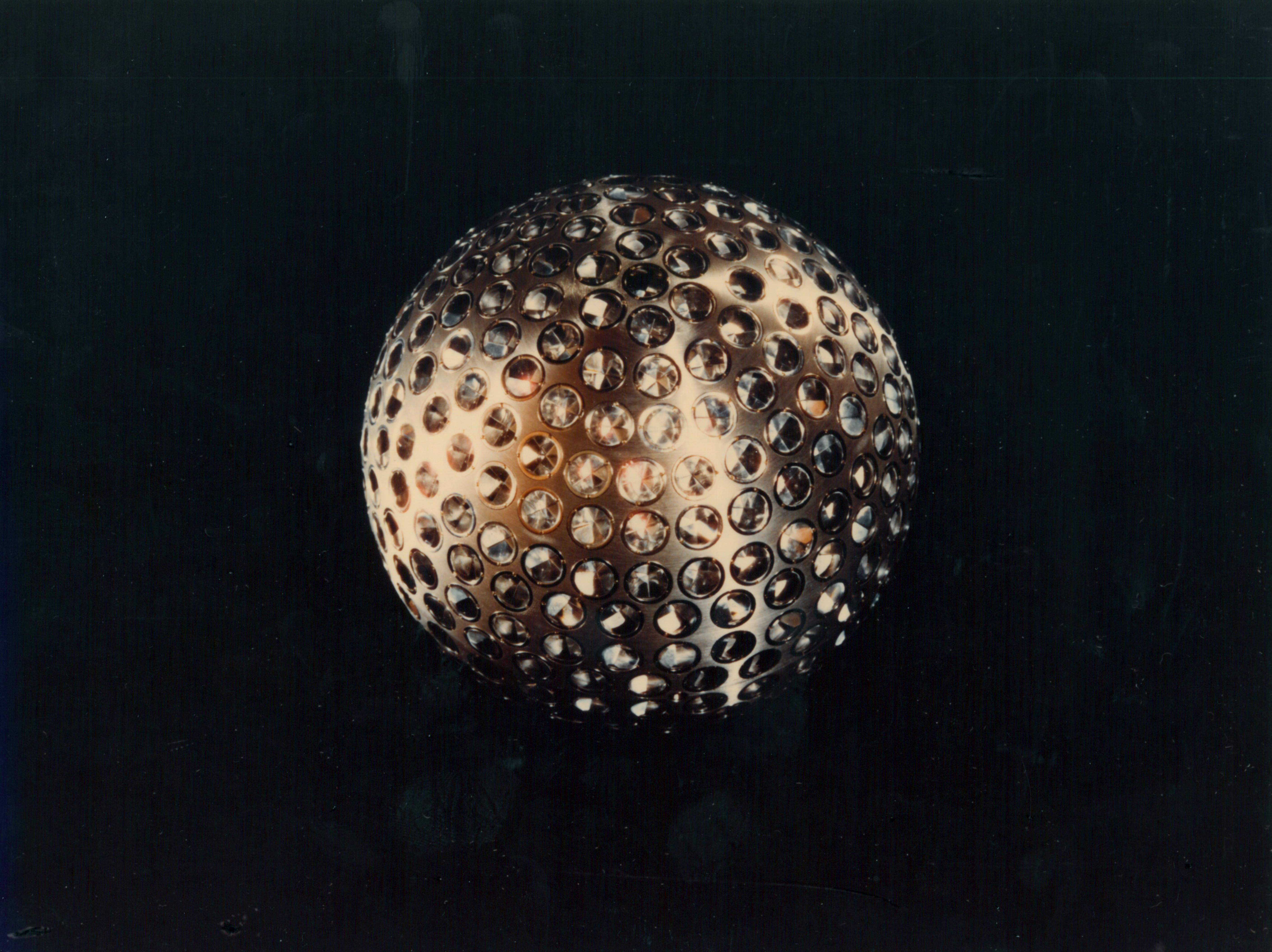
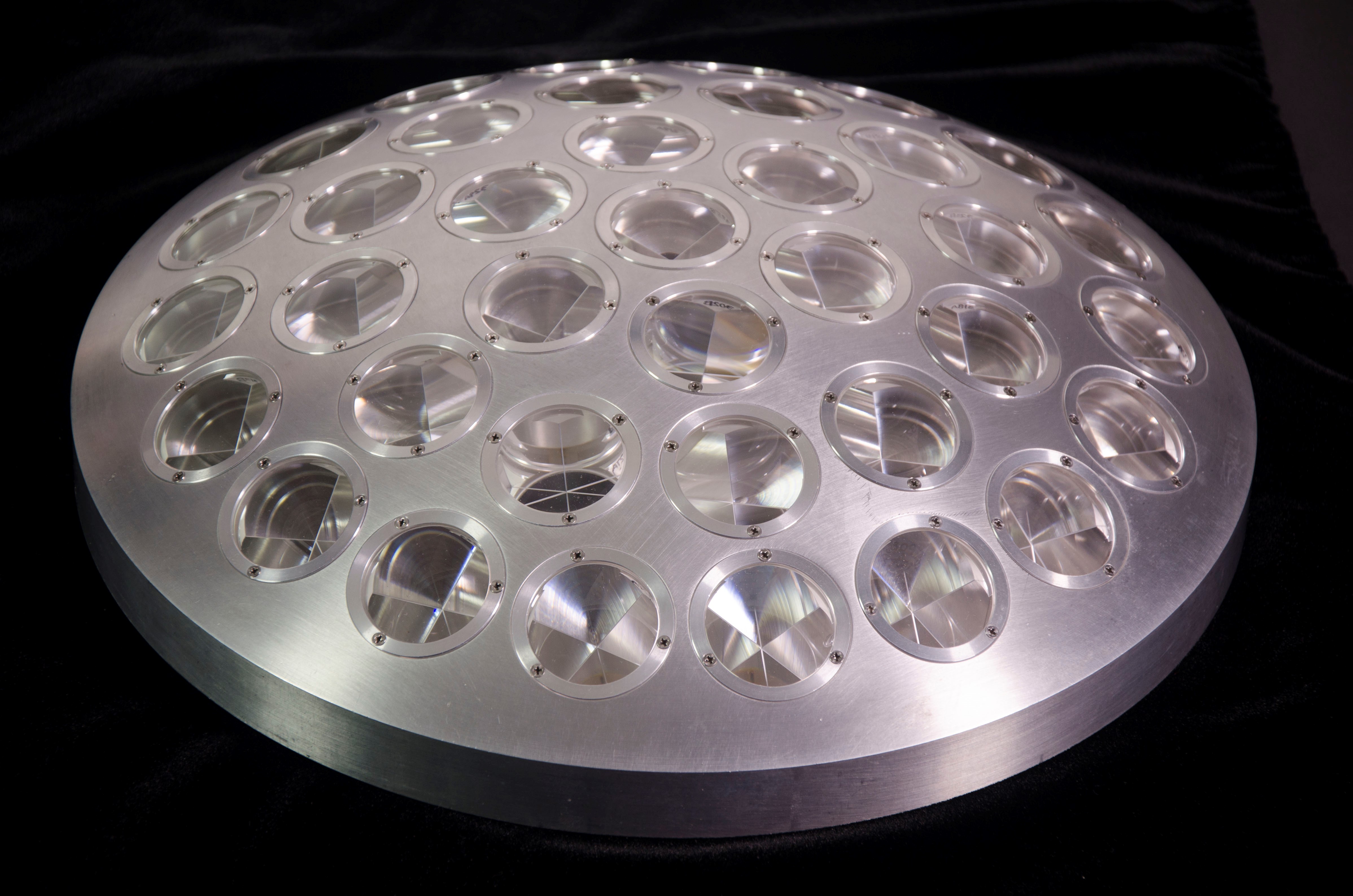
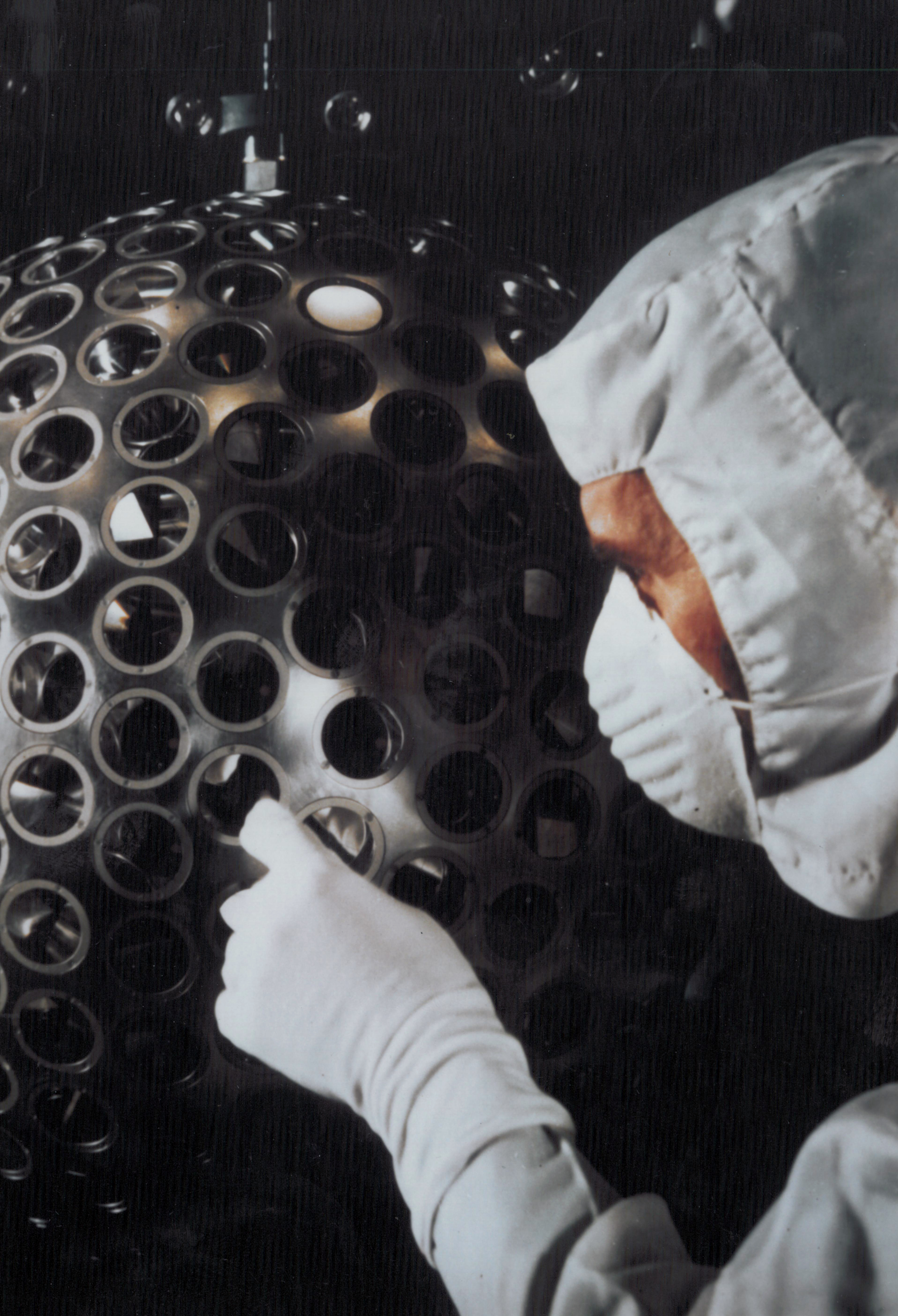
Built to last, the 900-pound (about 400 kilograms) satellite is passive, with no on-board sensors or electronics and no moving parts. Its brass core is covered by an aluminum shell that is dotted with 426 retroreflectors, making the satellite look like a giant golf ball.
“LAGEOS is elegantly simple – a ball covered with reflecting prisms,” said Stephen Merkowitz, manager of NASA’s Space Geodesy Project at the agency’s Goddard Space Flight Center in Greenbelt, Maryland. “But it set a new standard for laser ranging and has provided 40 years of continuity for these measurements.”
The satellite was launched from the Vandenberg Air Force Base in California. The design, development and construction of the orbiter was managed by NASA’s Marshall Space Flight Center in Huntsville, Alabama.
LAGEOS travels in a stable circular, pole-to-pole orbit more than 3,600 miles (5,900 kilometers) above Earth’s surface. At this altitude – medium Earth orbit – the satellite feels very little atmospheric drag and can be observed by ground stations on different continents simultaneously.
Over the years, 183 stations worldwide have ranged to LAGEOS, and dozens still do. A laser pulse is transmitted from a ground station and bounces off one of the satellite’s retroreflectors, directing part of the signal back to the station. The time it takes the pulse to make this round trip is measured precisely and used to calculate the distance between the satellite and the station.
This technique is called satellite laser ranging. By making these measurements over time, the absolute positions of the stations – relative to Earth’s center of mass – can be determined. From that, subtle changes in the positions of the stations relative to one another can be calculated.
One of the original goals of LAGEOS was to enable accurate measurements of the movements of the major plates that make up Earth’s crust. By the time the satellite was launched, the theory of plate tectonics was established, already supported by evidence of seafloor spreading and magnetic patterns in the crust. However, questions remained about how much the plates were moving in modern times and how that information could be applied to help understand earthquakes.
“What had been missing was a way to measure the speed and direction of plate movement over time,” said Frank Lemoine, a geophysical scientist at Goddard.
Satellite laser ranging had begun before LAGEOS, but early measurements had accuracies on the order of about 3 feet (1 meter). LAGEOS would make it possible to achieve accuracies of less than half an inch (1 centimeter) – the level needed to detect tectonic plate motion. Modern measurements have improved by another factor of 10.
“At the time, people couldn’t believe that we could actually range to a satellite orbiting at that altitude with such high accuracy,” said Erricos Pavlis, a researcher with the University of Maryland, Baltimore County.
These precise measurements also made it possible to detect small irregularities in Earth’s rotation, caused by the movement of mass in the atmosphere and oceans, and polar motion – the migration of the planet’s axis of rotation. Ranging to LAGEOS was good enough to reveal small perturbations in the satellite’s orbit, which provided the basis for early gravity models of Earth. The satellite also was used to detect a rebounding of Earth’s crust in regions where it had flattened slightly when ancient ice sheets covered the Hudson Bay area, Finland and Scandinavia.
“Today, we see Earth as one system, with the planet’s shape, rotation, atmosphere, gravitational field and the motions of the continents all connected. We take it for granted now, but LAGEOS helped us arrive at that view,” said David E. Smith, who was the LAGEOS project scientist at Goddard and is now at the Massachusetts Institute of Technology in Cambridge.
A nearly identical sister satellite, LAGEOS-2, was launched in 1992 as a joint venture of the Italian Space Agency and NASA. This satellite travels in a complementary orbit, and together, the two enabled a wider range of studies. The data from this pair were used to confirm one prediction of Einstein’s general theory of relativity: frame dragging. This is a tiny perturbation of an object’s orbit around a massive rotating central body, called the gravitomagnetic or Lense–Thirring effect.
LAGEOS also led to the discovery of other subtle effects. One was the seasonal Yarkovsky effect, a tiny braking force that occurs when sunlight heats one side of the spacecraft and the spacecraft later emits that heat. This drag is a variation of the original Yarkovsky effect, which takes place because of the rotation of the satellite about its axis. The seasonal version takes place over the course of its orbit around Earth.
The seasonal Yarkovsky effect – along with other miniscule forces – lowers LAGEOS’ orbit by a fraction of an inch (about 1 millimeter) each day.
“These and related effects are of particular interest lately because they can redirect the orbits of small objects, such as near-Earth asteroids,” said David Rubincam, a Goddard scientist involved in these studies.
NASA’s OSIRIS-REx spacecraft will investigate the Yarkovsky effect as part of its mission to study asteroid Bennu and return a sample to Earth for analysis.
These days, LAGEOS is part of a constellation of satellites that help establish and maintain the terrestrial reference frame, which links together navigation systems across the globe and serves as a fundamental reference for interplanetary navigation of spacecraft. The two LAGEOS satellites have the unique role of defining the origin, or center point, of the terrestrial reference frame; this is based on Earth’s center of mass.
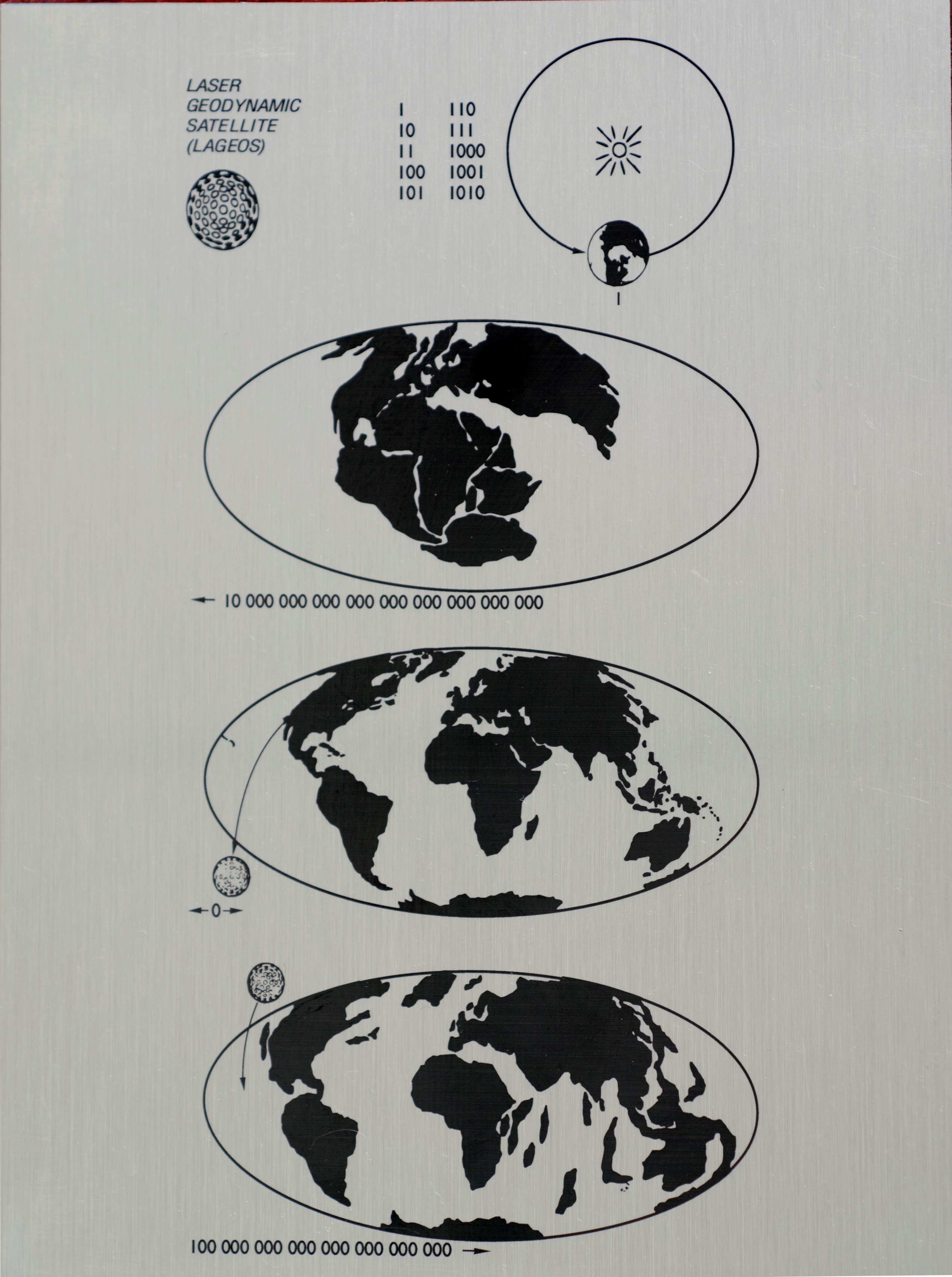
Still going strong on its 40th anniversary, LAGEOS is expected to revolve around Earth for millions of years. With that in mind, the orbiter carries a plaque designed by Carl Sagan. Most of the plaque is devoted to three panels, each with a map of Earth at a different epoch. The top panel represents Earth 268 million years ago, when the continents were joined as a single land mass. The middle panel shows the modern-day configuration of the continents. The last panel projects the configuration 8.4 million years in the future, when the satellite was originally predicted to finally fall to Earth.
“There is a lot of optimism embodied in this message to the future,” said Merkowitz. “It represents the vision that went into launching a satellite designed to operate for ages to come.”
Related Links
Elizabeth Zubritsky
NASA’s Goddard Space Flight Center, Greenbelt, Md.