


![Request for Information – Potential [Placeholder for Prize]](https://assets.science.nasa.gov/dynamicimage/assets/science/missions/a-step/FFR_Earth_Background_20251120%20.png?w=1024)


Landform Evolution Modeling (LEM) Group
Core Functions
- We perform computer modeling of the interaction of different landform-evolving processes acting upon a planetary surface.
- By comparing the results of this modeling to spacecraft observations of a real landscape, we can constrain and quantify:
- The range of physical and material properties that characterize a particular environment.
- The initial geological and environmental conditions.
- The identities of the major landform evolving processes that have acted upon the landscape.
- We have advanced the MARSSIM landform evolution model in order to apply it to an ever-broader range of planetary environments, and distribute the results to the community.
- We are also involved in the production of topographic maps of a range of planetary surfaces using the Ames Stereo Pipeline, which represents an essential dataset for quantitatively evaluating the results of landform evolution modeling.
Group Members

Jeff Moore
NASA Ames Research Scientist, whose research has focused on a range of topics relating to the geologic evolution of planetary landscapes and crustal materials.

Orkan Umurhan
SETI Research Scientist resident at NASA Ames, a planetary physicist who brings an applied mathematical background to the landform evolution modeling group.

Oliver White
SETI Research Scientist resident at NASA Ames, who brings the experience of topographic and geological mapping of planetary surfaces to the landform evolution modeling group.
Charles J. Barnhart
Former NASA Postdoctoral Fellow at Ames who investigated valley network formation on Mars.

Ross Beyer
SETI Research Scientist resident at NASA Ames, who brings his extensive experience of producing digital elevation models (DEMs) of planetary surfaces using Ames Stereo Pipeline to the landform evolution modeling group.
Background of LEM Work
Various simple landform evolution models had been developed prior to the 1990s, but they were necessarily limited in size and spatial resolution. More than twenty years of development have now yielded high-resolution models such as MARSSIM. It is this model that has been utilized by researchers of the NASA Ames LEM group since 2000 to model landform evolution due to the great diversity of geological processes that it can simulate, its flexible construction whereby new modules can be added relatively easily to cover additional processes, and its consequential applicability to a wide range of geological contexts across the solar system. These studies have always involved Alan Howard of the University of Virginia/Planetary Science Institute, the creator of the model, and so they have always been thoroughly informed with respect to the mechanics of the model and its capabilities. MARSSIM quantitatively evaluates processes modifying planetary surfaces including rock weathering, surface fluid flow, fluvial erosion, sediment transport and deposition, groundwater sapping, glacial flow of ice, mass wasting, aeolian deposition, soil hardening, lava flows, sublimation erosion and volatile deposition, groundwater flow, and impact cratering.
The model is open-source and the current version and documentation are maintained at http://erode.evsc.virginia.edu.
Scientific Research and Model Advancement
How accurately observations can be replicated in a LEM simulation depends on the extent to which the construction of the model is grounded in the relevant physics and chemistry. The LEM group has advanced the construction of MARSSIM’s coding in order to investigate the formation and evolution of a variety of disparate planetary landscapes across the Solar System, research that has been published in several groundbreaking papers over the last decade. Below is a selection of studies that is representative of the research of the LEM group:
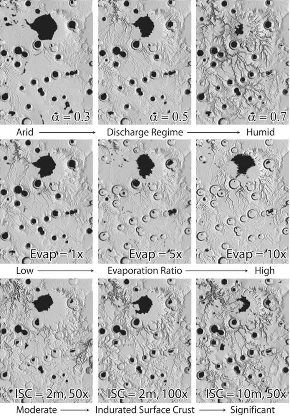
- Precipitation and valley network formation on Mars and Titan: Members of the group have led studies investigating the precipitation conditions that are necessary to explain the appearance of fluvial channels on Mars and Titan, two Solar Systems objects that, like Earth, have accommodated hydrological cycles at some point in their histories. Barnhardt et al. (2009) used MARSSIM to demonstrate that Noachian-Hesperian-aged, late-stage valley network formation on Mars required numerous and repeated moderate flood events rather than one or a few continuous, multiyear, deluge-style flows. A crucial aspect of their study was to introduce a technique to MARSSIM that generates an estimated “initial conditions” DEM of a drainage catchment prior to network valley incision. They then explored how variations in three classes of environmental parameters related to fluvial processes and surface material properties evolve the initial conditions DEM. This study, therefore, represents a prime example of LEM used to infer climatic conditions based on geomorphic analyses, the results of which can then be used to inform independent global climate modeling analyses.
The investigation of Howard et al. (2016) used MARSSIM to investigate how coarse debris delivered to channels on Titan from erosion respectively inhibits further channel erosion on these two bodies. Some fluvially eroded portions of the equatorial region of Titan contain numerous circular structures that are likely highly degraded large impact craters surviving from the late heavy bombardment. In order to identify what mechanism can chemically or physically break down the ice that forms Titan’s crust to degrade these craters, a model was created within MARSSIM involving fluvial erosion into an impact-generated megaregolith that contains a modest component of gravel-sized debris. The study found that even if this substrate includes only a small component of coarse gravel, a lag deposit will eventually accumulate on channel beds that will greatly slow further erosion while dendritic networks with appreciable relief may still remain, and pre-existing large features such as multi-kilometer impact craters remain recognizable (although degraded).
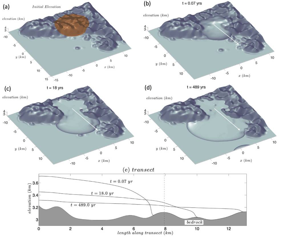
- Sublimation-driven erosion on Hyperion: The Saturnian satellite Hyperion has a unique sponge-like appearance characterized by a distinct lack of appreciable intercrater plains on a saturation-cratered surface, with a reticulate, honeycomb pattern of narrow divides between old craters. Howard et al. (2012) attempted to derive this peculiar landscape using MARSSIM’s cratering, weathering, mass wasting, and non-linear creep modules. The investigation found that the closest match to the observations in terms of slope distribution was achieved for a combination of the loss to space of ballistic ejecta during impact events (removing a source of material to fill in depressions and create flat intercrater plains) and appreciable subsequent modification of crater morphology occurring through mass-wasting accompanied by sublimation, probably facilitated by the loss of carbon dioxide as a component of the relief-supporting matrix of the bedrock. During early stages of crater degradation, steep, crenulate bedrock slopes occupy the upper crater walls with abrupt transitions downslope onto smooth slopes near the angle of repose mantled by mass wasting debris, as can be seen within young craters. Long-continued mass wasting eventually results in slopes totally mantled with particulate debris. This mass wasting effectively destroys small craters, at least in part accounting for the paucity of sub-kilometer craters on Hyperion.

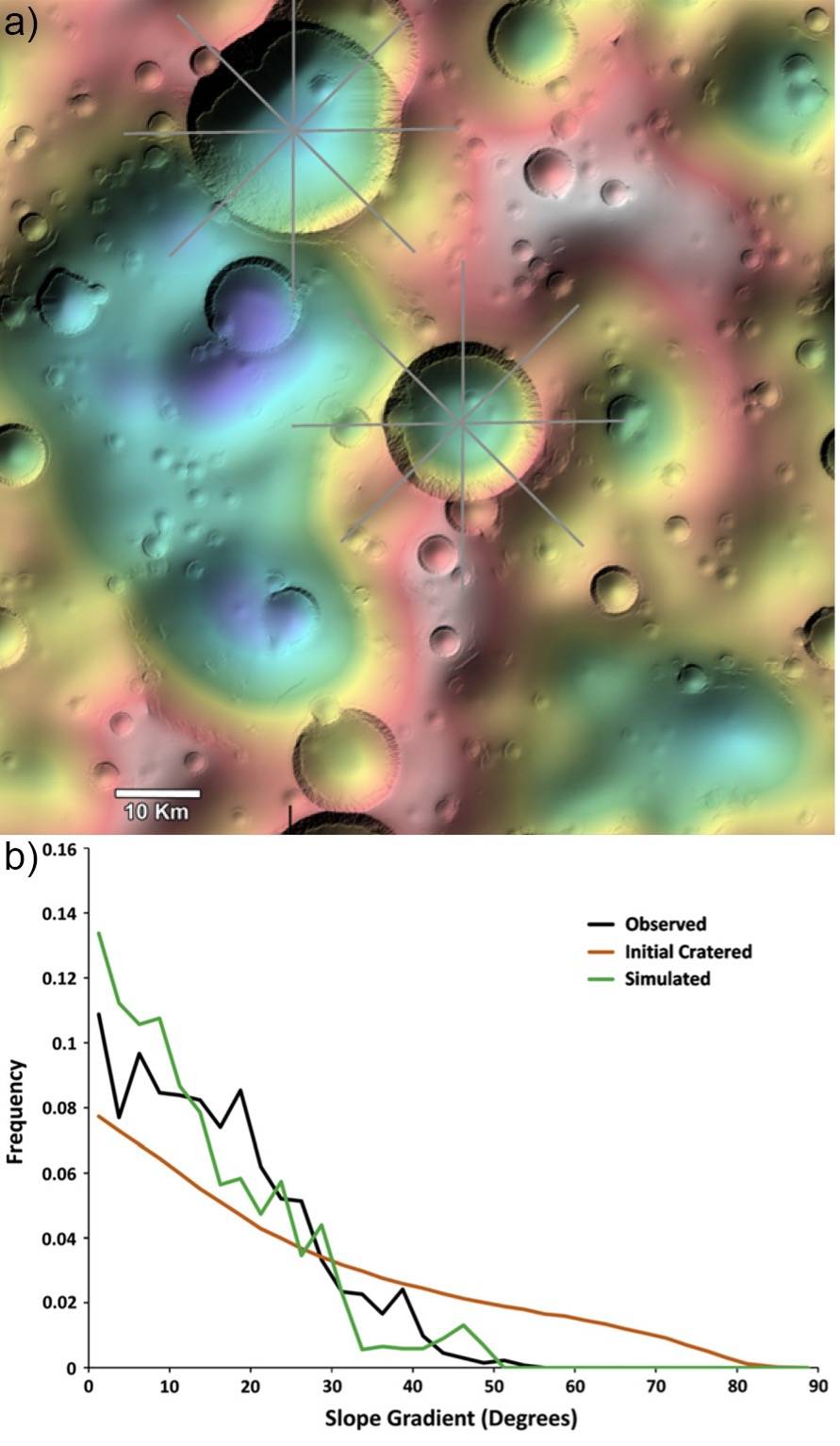
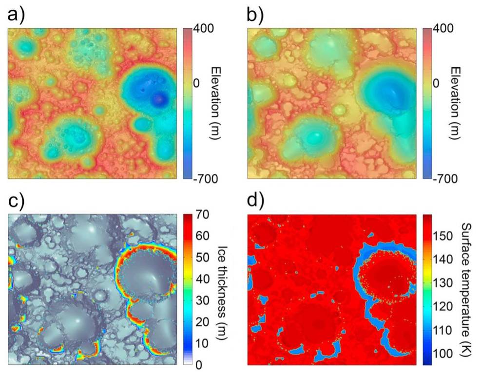
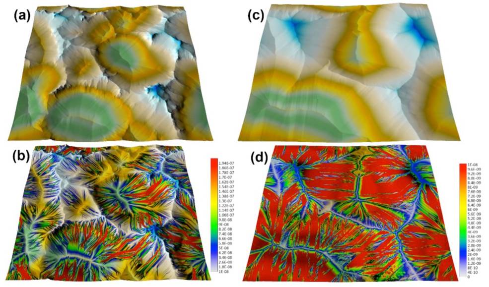
- Sublimation-driven erosion in the ice pinnacle terrain of Callisto: The landscape of the Galilean satellite Callisto exhibits widespread erosion from some non-impact-induced process, and is characterized by smooth, undulating dark albedo surfaces with isolated high albedo knobs that are remnants of crater rims. To investigate what processes give rise to this landscape, Howard and Moore (2008) developed a model within MARSSIM that incorporated sublimation erosion of ice from exposed bedrock on crater walls, composed of ice-cemented dust, with non-linear mass wasting of the released dust and re-deposition of the ice on convex summits. The model reproduced the essential elements of the pinnacle terrain on Callisto, but the physical processes were only modeled heuristically. White et al. (2016) substantially advanced the physical treatment of the processes examined in Howard and Moore (2008) by MARSSIM, modifying it to consider the effects of the composition and concentration of different ice species within the crust, and developed new, temperature-dependent ice sublimation and re-deposition modules that take into account latitude-dependent solar illumination and surface re-radiation. 4.5 Gyr duration simulations were performed whereby carbon dioxide and water were separately modeled as the crustal ice species. Sublimating a crustal content of 10% carbon dioxide ice yields present-day landform degradation and regolith coverage that is comparable to what is observed on Callisto, while the water ice simulations reproduced the essential features of pinnacle ice distribution at both the equator and mid-latitudes. A nominal crustal water ice content of 33% produces a maximum pinnacle ice thickness of 64 m, with pinnacle height likely limited by collapse or mass wasting of the ice once it reaches a certain thickness.
- Glacial flow on Pluto: The present LEM group are all team members on the New Horizons mission that flew past Pluto in 2015 and so have been deeply involved in the research of Pluto’s geology that the data returned by the mission allowed. One of the most compelling geological features on Pluto is Sputnik Planitia, a vast deposit of nitrogen ice contained within an impact basin that is undergoing resurfacing via sublimation and re-deposition, solid-state convection, and glacial flow. Nitrogen ice at Pluto conditions exhibits low viscosity, and valley glaciers sourced from uplands to the east have been observed to flow into Sputnik Planitia. Motivated by these observations, Umurhan et al. (2017) developed a glacial flow model for nitrogen ice within MARSSIM that takes into account its published thermophysical and rheological properties. This model assumes that glacial ice flows laminarly and has a low aspect ratio, which permits a vertically integrated mathematical formulation. The flow model was used to resolve questions motivated by features that are interpreted to be caused by glacial flow found on Sputnik Planitia. The investigation found that the wavy, transverse dark features found along the northern edge of Sputnik Planitia may be a transitory imprint of shallow topography just beneath the ice surface suggesting the possibility that a major shoreward flow event happened relatively recently, within the last few hundred years. Model results also support the interpretation that the prominent darkened features resembling flow lobes observed along the eastern edge of Sputnik Planitia may be the result of a basally wet nitrogen glacier flowing into the basin from the pitted highlands east of Sputnik Planitia
- Mass flow on the Lagrangian satellites of Dione and Tethys: The Lagrangian satellites that follow and trail the Saturnian satellites Dione and Tethys along their orbits display intriguing evidence of mass flow across their surfaces, which is most pronounced and best-imaged on Helene, the largest of the four, but the source of the flowing material (whether exogenically- or endogenically-sourced) has proven to be enigmatic. On Helene, the cratered surface has been heavily modified by mass flows as indicated by pronounced crater rim degradation and downslope-oriented chutes, ridges and mesas, which reach >5 km long and ~100-300 m wide, and merge onto broad featureless basins at lower elevations with concave lateral boundaries. Mesas are elevated a few tens of meters above adjacent parallel-oriented chutes that merge with smooth basin materials, suggesting that they define an earlier mass flow surface that has undergone dissection by renewed mass flows. Similar landforms are observed on Calypso. Telesto also exhibits concave seams in the center of its smooth plains, which are interpreted as sites where opposing mass flows converge. Umurhan et al. (2021) used MARSSIM to investigate how these features might form by mass wasting, and advanced the model by implementing a new feature that treats regolith as a “plastic” Bingham-like deformable medium. They concluded that the simulations that assume deep flows with a Bingham rheology most successfully replicate the observed morphology of the Lagrangian satellites, with development of chutes and mesas appearing to be an intrinsic consequence of progressive, differential cessation of Bingham flows as surface relief declines. The preferential location of long mass flows on the leading side of Helene suggests the accumulation of exogenous granular ice as a major source of the mobile material. Estimated rates of deposition derived from the current E-ring system are very low, suggesting alternative sources such as cryovolcanic or impact-generated debris from Dione or Tethys, or a catastrophic recent event in the inner satellite system of Saturn.
Publications
(In Chronological Order)
Howard, A.D., Moore, J.M. (2008) Sublimation-driven erosion on Callisto: A landform simulation model test. Geophys. Res. Lett., 35, L03203, doi:10.1029/2007GL032618.
Barnhart, C.J., Howard, A.D., Moore, J.M. (2009) Long-term precipitation and late-stage valley network formation: Landform simulations of Parana Basin, Mars. J. Geophys. Res., 114, E01003, doi:10.1029/2008JE003122.
Howard, A.D., Moore, J.M., Schenk, P.M., White, O.L., Spencer, J. (2012) Sublimation driven erosion on Hyperion: Topographic analysis and landform simulation model tests. Icarus, 220, 268-276, doi:10.1016/j.icarus.2012.05.013.
White, O.L., Umurhan, O.M., Moore, J.M., Howard, A.D. (2016) Modeling of ice pinnacle formation on Callisto. J. Geophys. Res. Planets, 121, 21-45, doi:10.1002/2015JE004846.
Howard, A.D., Breton, S., Moore, J.M. (2016) Formation of gravel pavements during fluvial erosion as an explanation for persistence of ancient cratered terrain on Titan and Mars. Icarus, 270, 100-113, doi:10.1016/j.icarus.2015.05.034.
Umurhan, O.M., Howard, A.D., Moore, J.M., Earle, A.M., White, O.L., et al. (2017) Modeling glacial flow on and onto Pluto’s Sputnik Planitia. Icarus, 287, 301-319, doi:10.1016/j.icarus.2017.01.017.
Moore, J.M., Howard, A.D., Umurhan, O.M., White, O.L., et al. (2017) Sublimation as a landform-shaping process on Pluto. Icarus, 287, 320-333, doi:10.1016/j.icarus.2016.08.025.
Umurhan, O.M., Howard, A.D., White, O.L., Schenk, P.M., Moore, J.M., (2021) Modeling global-scale mass flows on the Lagrangian satellites of Dione and Tethys. Icarus, 369, 114612, doi:10.1016/j.icarus.2021.114612.