


![Request for Information – Potential [Placeholder for Prize]](https://assets.science.nasa.gov/dynamicimage/assets/science/missions/a-step/FFR_Earth_Background_20251120%20.png?w=1024)


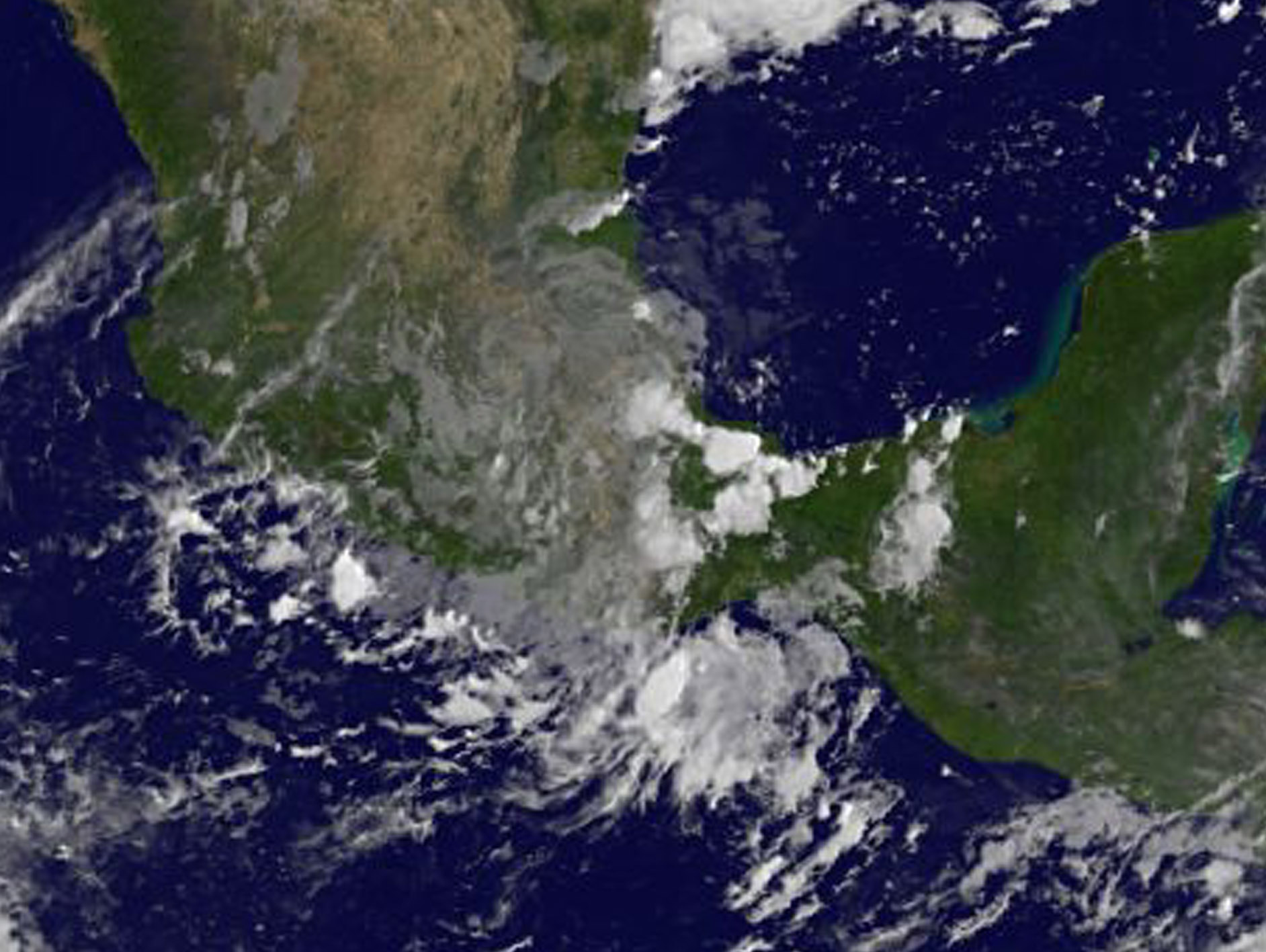
NASA Sees Remnants of Katia Dissipating After Mexico Landfall
NOAA’s GOES East satellite captured an image of former Hurricane Katia’s remnant clouds over southern Mexico after its landfall.
Katia made landfall at 10 p.m. CDT/11 p.m. EDT on Friday night, Sept. 8 as a hurricane with maximum sustained winds near 75 mph (120 kph) near Tecolutla, Mexico. That’s about 120 miles (190 km) south-southeast of Tampico.
At NASA’s Goddard Space Flight Center in Greenbelt, Maryland, an image was created using visible light data from NOAA’s GOES-East satellite imagery at 7:45 a.m. EDT (1145 UTC) on Sept. 9, 2017. Katia’s remnants were quickly dissipating. In the image the circulation center was not easily identifiable, and the clouds associated with the remnants appeared elongated from southwest to northeast.
NOAA manages the GOES series of satellites, and NASA uses the satellite data to create images and animations. The animation was created by the NASA/NOAA GOES Project at NASA’s Goddard Space Flight Center in Greenbelt, Maryland.
At 10 a.m. CDT (11 a.m. EDT/1500 UTC) on Saturday, Sept. 9, the National Hurricane Center issued the final advisory on Katia. At that time the remnants of Katia were located near 20.0 degrees north latitude and 97.9 degrees west longitude.
The remnants were moving toward the west-southwest near 5 mph (7 kph), and this motion is expected to continue for the next day or so. Maximum sustained winds were near 35 mph (55 kph) with higher gusts. The estimated minimum central pressure was 1004 millibars.
Katia has dissipated over the terrain of eastern Mexico but threat for heavy rainfall continues.
By Rob Gutro
NASA’s Goddard Space Flight Center
Sep. 08, 2017 – (Update #2) Satellites Show Hurricane Katia Crawling to the Mexico Coast
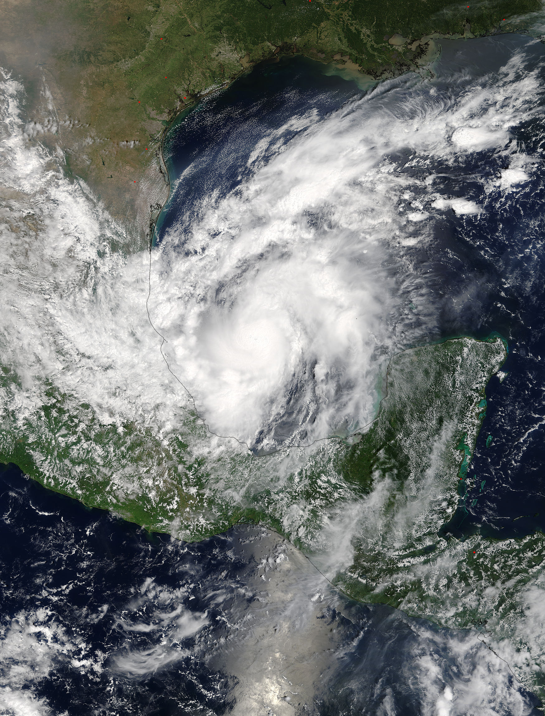
Two days of satellite imagery from NASA’s Terra and NOAA’s GOES East satellites showed that Hurricane Katia was starting to crawl to the coast of southeastern Mexico.
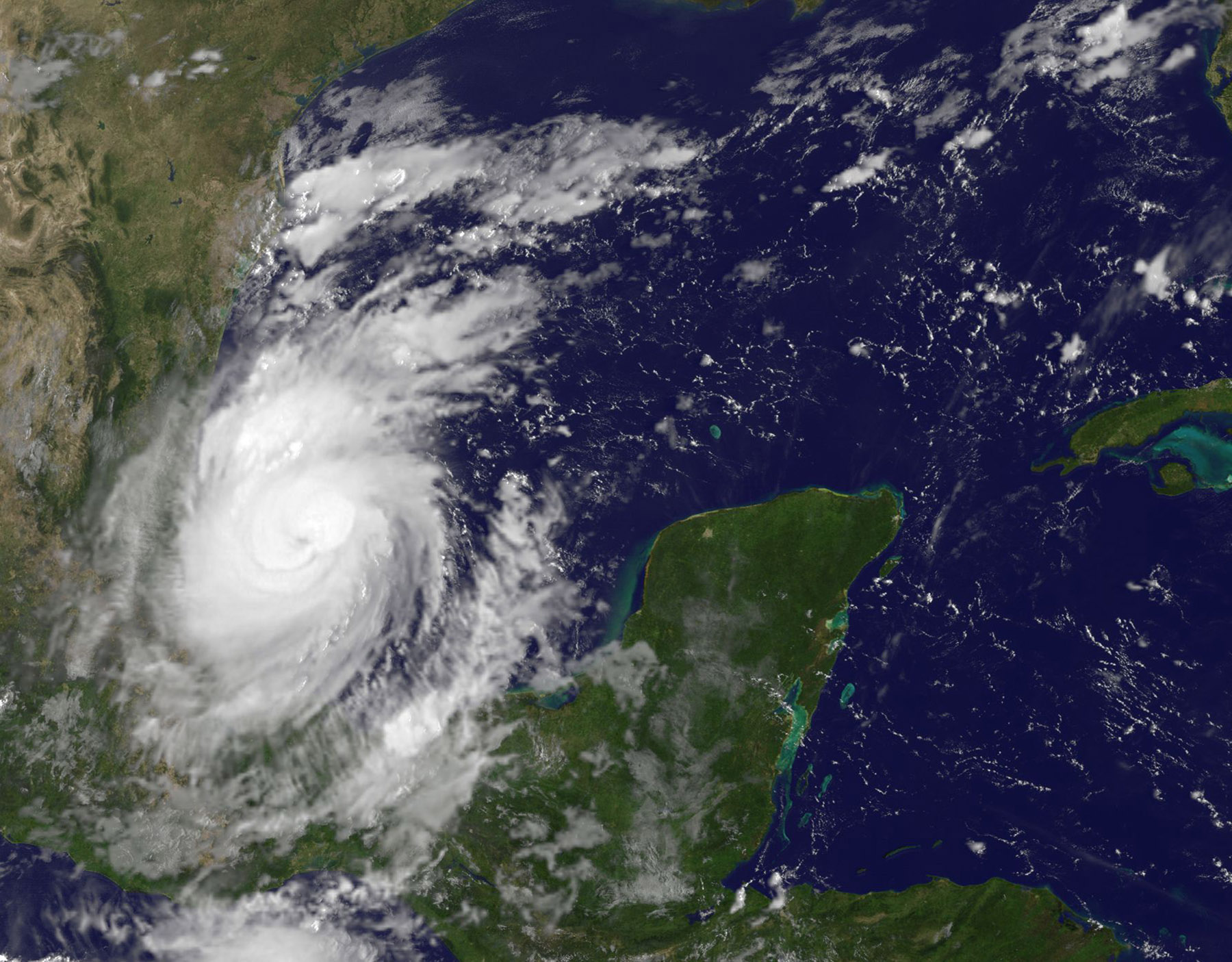
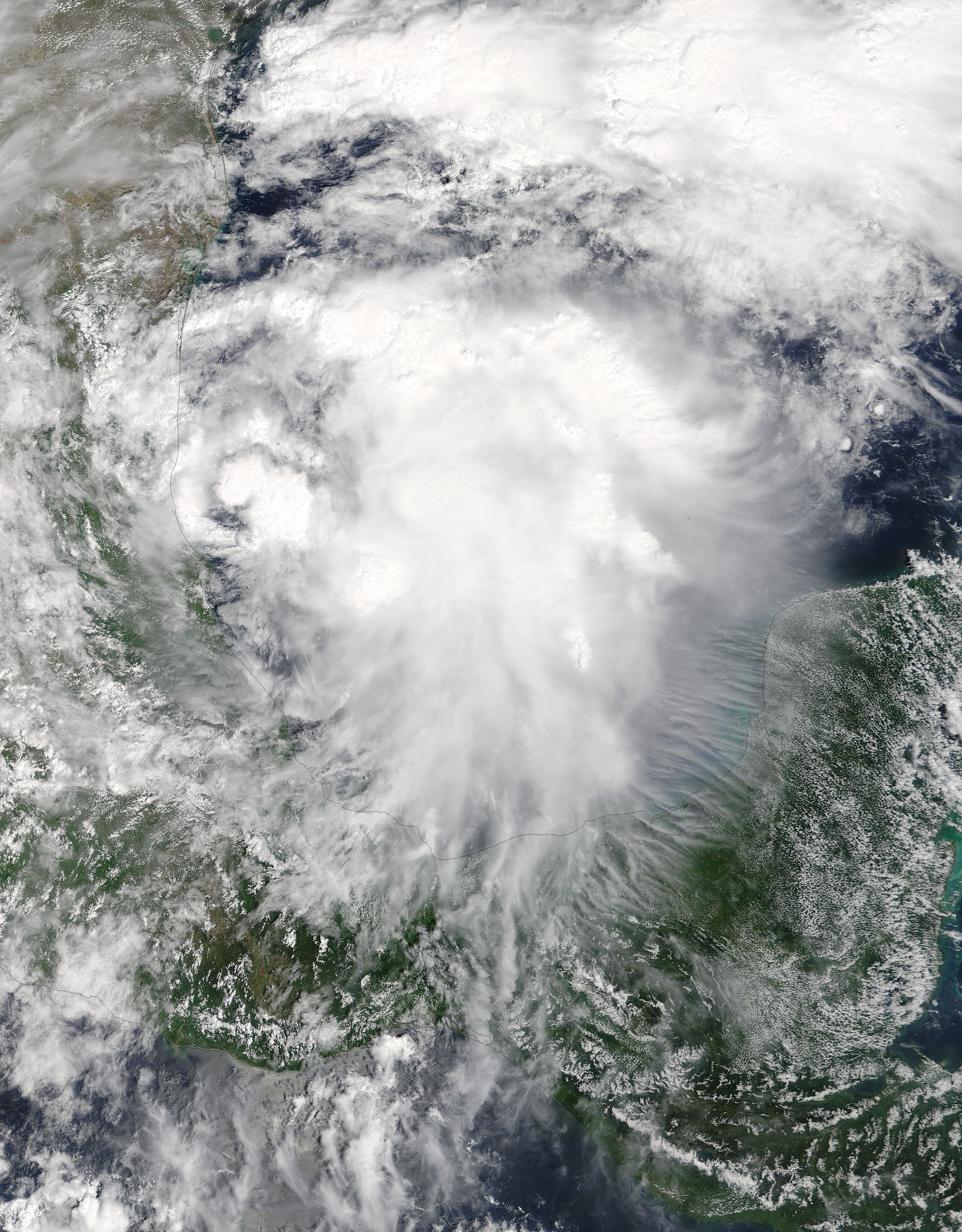
On Sept. 7 at 1 p.m. EDT (1700 UTC) the Moderate Resolution Imaging Spectroradiometer or MODIS instrument aboard NASA’s Terra satellite captured a visible-light image of Hurricane Katia in the southwestern Gulf of Mexico. The image showed powerful bands of thunderstorms around the center of circulation but the storm’s eye was not visible. The western quadrant of the storm was over the east coast state of Veracruz, Mexico.
There is the indication of an eye in a visible light image from NOAA’s GOES East satellite on Sept. 8 at 9:15 a.m. EDT (1315 UTC).
The National Hurricane Center noted that a NASA Global Precipitation Measurement mission (GPM) satellite microwave composite image indicated improved banding over the western portion of the circulation and the earlier ragged eye presentation has become much more distinct. Katia is also starting to move toward the southwest.
On Sept. 8, the National Hurricane Center (NHC) said a Hurricane Warning is in effect for Cabo Rojo to Laguna Verde, and a Tropical Storm Warning is in effect from north of Cabo Rojo to Rio Panuco and south of Laguna Verde to Puerto Veracruz.
Storm Surge, Hurricane Winds and Heavy Rainfall
NHC noted that dangerous storm surge will raise water levels by as much as 5 to 7 feet above normal tide levels near and to the north of where Katia makes landfall. Near the coast, the surge will be accompanied by large and destructive waves.
Katia is expected to produce total rain accumulations of 10 to 15 inches over northern Veracruz, eastern Hidalgo, and Puebla. Katia is also expected to produce total rain accumulations of 2 to 5 inches over southern Tamaulipas, eastern San Luis Potosi, western Hidalgo, eastern Queretaro, and southern Veracruz through Saturday evening. Isolated maximum amounts of 25 inches are possible in northern Veracruz, eastern Hidalgo, Puebla, and San Luis Potosi. This rainfall may cause life-threatening flash floods and mudslides, especially in areas of mountainous terrain.
Katia’s Location
At 7 a.m. CDT (8 a.m. EDT/1200 UTC) on Sept. 8 the center of Hurricane Katia was located near 21.1 degrees north latitude and 95.6 degrees west longitude. That’s 140 miles (220 km) north-northeast of Veracruz, Mexico.
Katia is moving toward the west-southwest near 3 mph (6 km/h) and this general motion is expected to continue until the system makes landfall within the hurricane warning area by early Saturday, Sept. 9.
Maximum sustained winds are near 90 mph (150 kph) with higher gusts. Some additional strengthening is forecast during the next day or so and Katia could be near major hurricane strength at landfall. Hurricane-force winds extend outward up to 10 miles (20 km) from the center and tropical-storm-force winds extend outward up to 60 miles (95 km). The estimated minimum central pressure is 977 millibars.
The National Hurricane Center forecasts Katia to make landfall on Saturday, Sept. 9.
For updates on Katia, visit: www.nhc.noaa.gov
By Rob Gutro
NASA’s Goddard Space Flight Center
Sep. 08, 2017 – (Update #1) Satellite Animation Sees Hurricanes Katia, Irma and Jose
Credits: NASA-NOAA
Sep. 07, 2017 – (Update #2) Satellites Show Hurricane Katia Not Moving Much
Satellite imagery from NASA’s Terra and Aqua satellites showed that Hurricane Katia had not moved much, just about 30 miles in 16 hours.
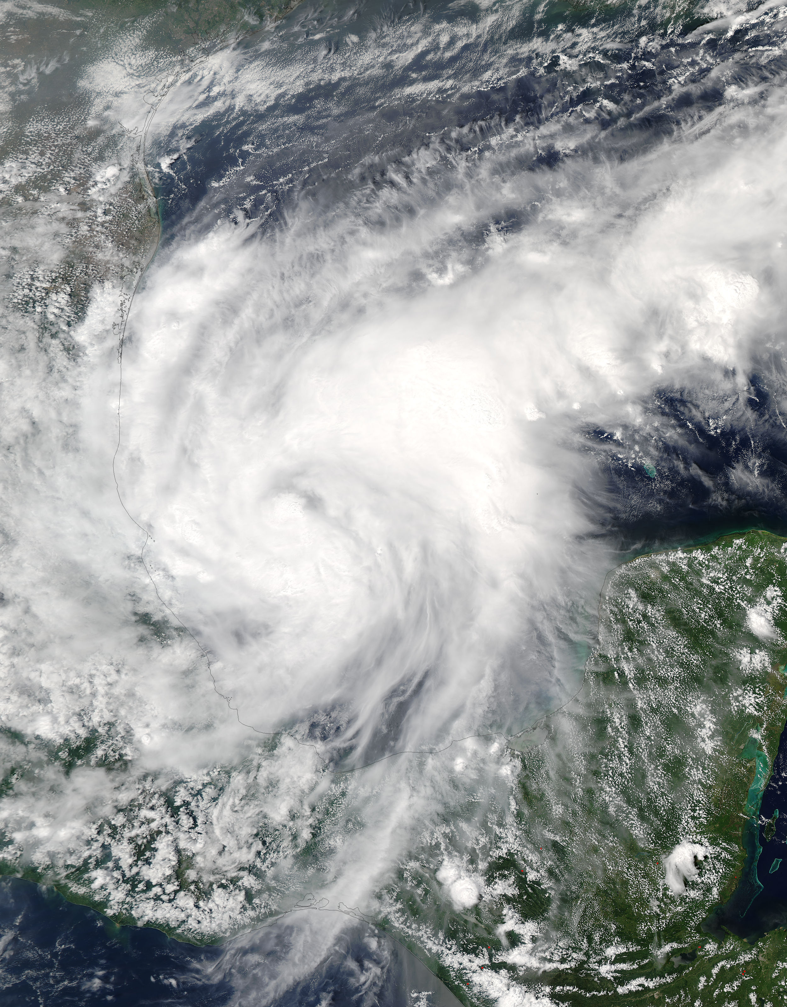
On Sept. 6 at 3:25 p.m. EDT (1925 UTC) the Moderate Resolution Imaging Spectroradiometer or MODIS instrument aboard NASA’s Terra satellite captured a visible-light image of Katia in the southwestern Gulf of Mexico. The image showed powerful bands of thunderstorms around the center of circulation. The western quadrant of the storm was over the east coast state of Veracruz, Mexico. At the time, the center of Katia was about 185 miles (295 km) east of Tampico, Mexico.
Katia strengthened into a hurricane on Sept. 6 at 4 p.m. CDT (5 p.m. EDT).
On Sept. 7, the National Hurricane Center (NHC) said a Hurricane Warning is in effect for Cabo Rojo to Laguna Verde, and a Tropical Storm Warning is in effect from north of Cabo Rojo to Rio Panuco and south of Laguna Verde to Puerto Veracruz.
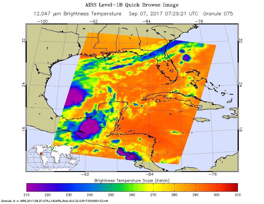
Infrared Imagery and Heavy Rainfall Expected
The Atmospheric Infrared Sounder or AIRS instrument aboard NASA’s Aqua satellite measured at cloud top temperatures in Hurricane Katia’s eastern side using infrared light. The AIRS data were taken on Sept. 7 at 3:29 a.m. EDT (0729 UTC). The data showed some very cold cloud top temperatures as cold as minus 63 degrees Fahrenheit (minus 53 degrees Celsius). NASA research has shown that storms with cloud tops that cold are high up in the troposphere and can generate heavy rainfall.
The infrared data was false-colored at NASA’s Jet Propulsion Laboratory in Pasadena, California, where AIRS data is managed.
That heavy rainfall is in the NHC forecast. NHC cautioned “Katia is expected to produce total rain accumulations of 10 to 15 inches over northern Veracruz and eastern Hidalgo, Puebla, and San Luis Potosi. Katia is expected to produce total rain accumulations of 2 to 5 inches over southern Tamaulipas, central San Luis Potosi, western Hidalgo, eastern Queretaro, and southern Veracruz through Saturday evening. Isolated maximum amounts of 25 inches are possible in northern Veracruz and eastern Hidalgo,
Puebla, and San Luis Potosi.”
Katia’s Location
At 10 a.m. CDT (11 a.m. EDT/1500 UTC) the center of Hurricane Katia was located near 21.6 degrees north latitude and 94.6 degrees west longitude. That’s about 215 miles (345 km) east of Tampico, Mexico. Katia is stationary and little overall motion is anticipated through late today. However, the hurricane is forecast to turn southwestward and approach the coast within the warning area late Friday or early Saturday.
Maximum sustained winds are near 80 mph (130 kph) with higher gusts. Some strengthening is forecast during the next 36 hours and Katia could be near major hurricane strength at landfall. Hurricane-force winds extend outward up to 10 miles (20 km) from the center and tropical-storm-force winds extend outward up to 45 miles (75 km). The minimum central pressure estimated from Air Force Hurricane Hunter observations is 980 millibars.
The National Hurricane Center forecasts Katia to move in a southwesterly direction and make landfall late on Friday, Sept. 8.
For updates on Katia, visit: www.nhc.noaa.gov
By Rob Gutro
NASA’s Goddard Space Flight Center
Sep. 07, 2017 – (Update #1) Satellite Animation Sees Category 5 Hurricane Irma and Tropical Storm Katia
Credits: NASA-NOAA GOES Project
Sep. 06, 2017 – NASA Sees Tropical Storm Katia Develop Near Mexico’s East Coast
NASA’s Terra satellite passed over Tropical Storm Katia as it was developing along Mexico’s east coast. On Sept. 5, the thirteenth tropical depression of the Eastern Pacific Ocean hurricane season formed about 80 miles (125 kph) east of Tampico, Mexico, in the western Gulf of Mexico.
The Moderate Resolution Imaging Spectroradiometer or MODIS instrument that flies aboard NASA’s Terra satellite captured a visible-light image of the depression as it was organizing on Sept. 5 at 1:10 p.m. EDT (1710 UTC). The image showed that deep convection and thunderstorms were forming over the center. By 4 p.m. EDT, the National Hurricane Center noted that the depression had formed.
At 10 a.m. CDT (1500 UTC), the center of Tropical Storm Katia was located near 21.7 degrees north latitude and 95.9 degrees west longitude. Katia was moving slowly toward the east-southeast near 5 mph (7 kph), and little motion is expected during the next day or so. Maximum sustained winds are near 45 mph (75 kph) with higher gusts. Strengthening is forecast and Katia could become a hurricane before it approaches the coast of Veracruz in a couple of days. The estimated minimum central pressure is 1004 millibars.
Because of the close proximity to land, the National Hurricane Center cautioned about the heavy rainfall the storm is expected to generate. Katia is expected to produce total rain accumulations of 5 to 10 inches over northern Veracruz, and 2 to 5 inches over far southern Tamaulipas, northeast Puebla, and southern Veracruz through Saturday morning. Isolated maximum amounts of 15 inches are possible in northern Veracruz. This rainfall may cause life-threatening flash floods and mudslides, especially in areas of mountainous terrain.
A Hurricane Watch could be required for portions of the Mexican state of Veracruz later today.
For updates from the National Hurricane Center, visit: www.nhc.noaa.gov.
By Rob Gutro
NASA’s Goddard Space Flight Center