


Farmers in Africa are highly vulnerable to the caprices of nature. For example, frost is a perennial agricultural hazard in parts of Africa, causing huge agricultural losses. In East Africa, the delicate crystalline coating causes millions of dollars in damage to crops such as tea and coffee. To protect their crops, farmers need answers to question like these: Under what conditions and where does frost often occur in the region? Where and when will it occur next?
The Kenya Meteorological Department (KMD) receives a flurry of requests from farmers and businesses each winter for this kind information. In addition, agricultural insurance companies in the country need independent and reliable data to identify frost affected areas to serve their clients effectively. Such insurance is a vital tool for African farmers and their families.
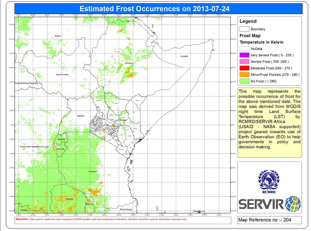
For these reasons, KMD, the Tea Research Foundation of Kenya ,which was created by the Ministry of Agriculture, and a Kenyan sector of an insurance giant called Aon reached out to the NASA Applied Sciences SERVIR project for support. In response, SERVIR’s Africa hub designed and implemented an automated, near real-time frost mapping system that identifies and displays frost-impacted areas by analyzing night time land surface temperature datasets from NASA’s Moderate Resolution Imaging Spectroradiometer (MODIS) aboard the Terra and Aqua satellites. Within a few hours of satellite data collection, the system emails daily, user-friendly maps identifying areas with high potential for frost to KMD and other end users. The maps’ color schemes make it readily apparent where problematic frost is likely to occur.
“The frost maps are excellent tools,” says James Kiguru of Aon. “These will give us a much stronger basis to conduct our assessments and will boost development of frost insurances. With your aid, in forecast and/or real time reports, we will be able to alleviate this problem and make our farmers smile. We are able to assist our clients — particularly farmers — when it comes to frost claims which otherwise would be attributed to negligence.”
This mapping system will soon incorporate KMD WRF numerical prediction model forecasts in addition to the satellite data-derived frost products to help map areas of potential frost up to 3 days in advance – giving farmers time to protect their crops. SERVIR’s Wireless Sensor Network (WSN) will be used to better define frost condition thresholds by collecting temperature, wind speed, and humidity observations in sample locations and correlating those with the forecasts and satellite data products.
SERVIR has sponsored training workshops and will continue to train regional officials in use of the frost alert system as well as a decision guide for using WSN frost data and satellite frost risk maps.
SERVIR’s frost mapping system demonstrates the critical role satellite imagery technologies can play in human lives. In addition to reducing losses to current crops, these frost maps can help farmers avoid frost-prone times and locations for future planting. The end result is better crop yields, supporting people and livelihoods in African countries.
SERVIR, a joint NASA/USAID initiative, translates satellite observations into useful information about land cover and land use, climate, water, agriculture, natural disasters, and more to help developing nations monitor, forecast, and respond to environmental changes. The SERVIR-Africa hub host organization is the Regional Centre for Mapping of Resources for Development (RCMRD) based in Nairobi.