


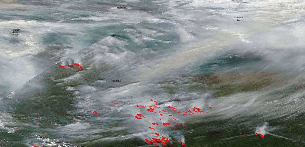
NASA’s Terra satellite captured this image of fires wreaking havoc across a large swath of Siberia on July 21, 2020. Huge clouds of smoke across the entire region are releasing huge amounts of carbon into the atmosphere. Fires in this area about the Arctic Circle have been mostly nonstop since April of this year.
As the permafrost thaws and the temperatures rise in the Arctic (above 66.5 degrees latitude) fires have been breaking out regularly and with ferocity. This year Siberia’s fire season which began in April has broken records with the amount of carbon the fires there have released into the atmosphere. Peat soils found in Arctic and far northern biomes contain huge amounts of carbon which is released when burned. These soils hold twice as much carbon as our atmosphere does currently.
This year according to NOAA, “The average global temperature in June was 1.71 degrees F above the 20th-century average of 59.9 degrees, making it the hottest June in the 140-year record. Nine of the 10 hottest Junes have occurred since 2010.” This year overall is on track as well to break records across the globe. There seems to be no end in sight to the Siberian fire season.
NASA’s satellite instruments are often the first to detect wildfires burning in remote regions, and the locations of new fires are sent directly to land managers worldwide within hours of the satellite overpass. Together, NASA instruments detect actively burning fires, track the transport of smoke from fires, provide information for fire management, and map the extent of changes to ecosystems, based on the extent and severity of burn scars. NASA has a fleet of Earth-observing instruments, many of which contribute to our understanding of fire in the Earth system. Satellites in orbit around the poles provide observations of the entire planet several times per day, whereas satellites in a geostationary orbit provide coarse-resolution imagery of fires, smoke and clouds every five to 15 minutes. For more information visit: https://www.nasa.gov/mission_pages/fires/main/missions/index.html
NASA’s Earth Observing System Data and Information System (EOSDIS) Worldview application provides the capability to interactively browse over 700 global, full-resolution satellite imagery layers and then download the underlying data. Many of the available imagery layers are updated within three hours of observation, essentially showing the entire Earth as it looks “right now.” Actively burning fires, detected by thermal bands, are shown as red points. Image Courtesy: NASA Worldview, Earth Observing System Data and Information System (EOSDIS). Caption: Lynn Jenner with information from NOAA and the NOAA Arctic Program
See also, Earth Observatory’s story Heat and Fire Scorches Siberia