


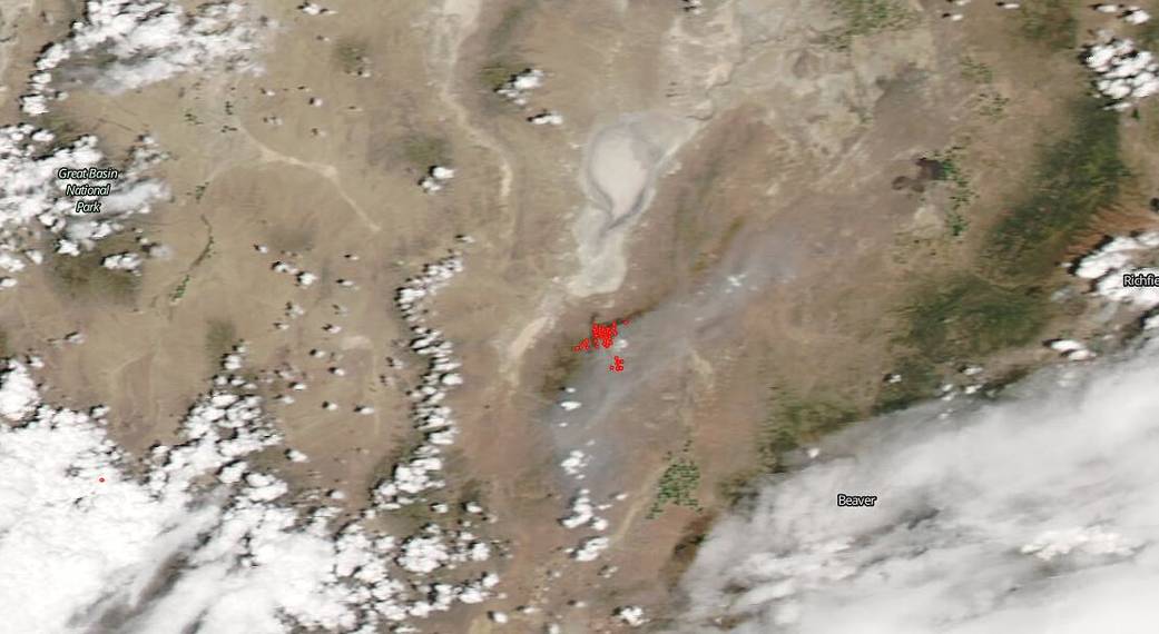
NASA’s Terra satellite captured this image of the Rock Path fire located 15 miles north of Milford, Utah on June 28, 2020. These fire began as two separate fires on June 25, 2020 with a lightning strike. The Antelope fire combined with the Rock Path fire when crews conducted a burn-out operation on June 26, 2020, specifically to combine the two fires into one for firefighting purposes. The resulting single fire retained the name Rock Path Fire. The Rock Path fire is burning in chaparral, brush and short grass. The fire is exhibiting moderate fire behavior with smoldering and group torching. The current (June 28) combined total for the Rock Path Fire is approximately 16,588 acres according to the National Interagency Fire Center (NIFC) which, when better mapping was done, was decreased by approximately 4,000 acres. This fire is 45% contained, also according to the NIFC. Red Flag Warning has the potential for wind-driven fire running through grasses with short spotting. There are no evacuations or closures at present (June 28)
NASA’s satellite instruments are often the first to detect wildfires burning in remote regions, and the locations of new fires are sent directly to land managers worldwide within hours of the satellite overpass. Together, NASA instruments detect actively burning fires, track the transport of smoke from fires, provide information for fire management, and map the extent of changes to ecosystems, based on the extent and severity of burn scars. NASA has a fleet of Earth-observing instruments, many of which contribute to our understanding of fire in the Earth system. Satellites in orbit around the poles provide observations of the entire planet several times per day, whereas satellites in a geostationary orbit provide coarse-resolution imagery of fires, smoke and clouds every five to 15 minutes. For more information visit: https://www.nasa.gov/mission_pages/fires/main/missions/index.html
NASA’s Earth Observing System Data and Information System (EOSDIS) Worldview application provides the capability to interactively browse over 700 global, full-resolution satellite imagery layers and then download the underlying data. Many of the available imagery layers are updated within three hours of observation, essentially showing the entire Earth as it looks “right now.” This satellite image was collected on June 28, 2020. Actively burning fires, detected by thermal bands, are shown as red points. Image Courtesy: NASA Worldview, Earth Observing System Data and Information System (EOSDIS). Caption: Lynn Jenner with information from Utah Fire Info.gov and the National Interagency Fire Center