


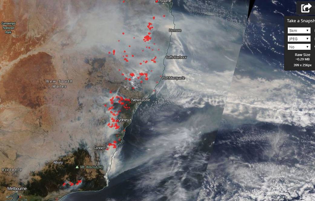
As devastating as the fires are in New South Wales, Australia, the smoke coming from those fires is causing its own set of hazards for residents in the area. Today’s Air Quality Indexes (AQI) for portions of this Australian state have seen areas with AQI’s of 1205 in the Southern Tablelands and 1179 in the Central Tablelands. Air Quality Indexes above 200 are considered hazardous. Southwest area of Sydney is experiencing AQI’s of 338, still well within the hazardous range. No end is in sight for these bushfires as weather conditions continue to promote the dangerous fires. Low humidity, drought, winds, and high temperatures continue throughout the region.
NASA’s Terra satellite captured this image on December 19, 2019 of the hotspots (where fires are located) and the smoke billowing from those areas. Terra’s onboard instrument, MODIS (Moderate Resolution Imaging Spectroradiometer) collected the image. Actively burning areas, detected by MODIS’s thermal bands, are outlined in red.
NASA’s satellite instruments are often the first to detect wildfires burning in remote regions, and the locations of new fires are sent directly to land managers worldwide within hours of the satellite overpass. Together, NASA instruments detect actively burning fires, track the transport of smoke from fires, provide information for fire management, and map the extent of changes to ecosystems, based on the extent and severity of burn scars. NASA has a fleet of Earth-observing instruments, many of which contribute to our understanding of fire in the Earth system. Satellites in orbit around the poles provide observations of the entire planet several times per day, whereas satellites in a geostationary orbit provide coarse-resolution imagery of fires, smoke and clouds every five to 15 minutes. For more information visit: https://www.nasa.gov/mission_pages/fires/main/missions/index.html
NASA’s Earth Observing System Data and Information System (EOSDIS) Worldview application provides the capability to interactively browse over 700 global, full-resolution satellite imagery layers and then download the underlying data. Many of the available imagery layers are updated within three hours of observation, essentially showing the entire Earth as it looks “right now.” Image Courtesy: NASA Worldview, Earth Observing System Data and Information System (EOSDIS). Caption: Lynn Jenner with information from the New South Wales Government Planning, Industry and Environment website.