


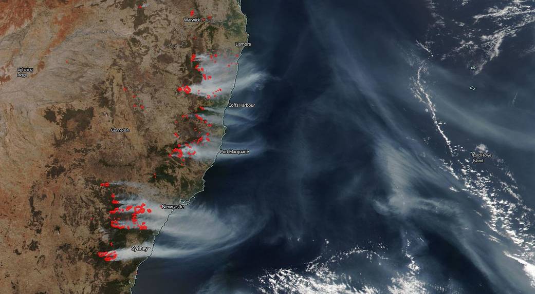
NOAA-NASA’s Suomi NPP satellite captured this image of the ongoing conflagrations in New South Wales, Australia on December 04, 2019. One area that has been hit particularly hard by these bushfires is the national parks system there. More than 10% of the area covered by all the national parks in New South Wales has been torched by these unending blazes. In the Blue Mountains world heritage area 20% has been destroyed by flames. The previous fire season (2018) saw 80,000 hectares (308 sq. miles) burned in the national parks. This season ten times that amount has been destroyed in the national parks out of the total of 1.9 million total hectares (7,335 sq. miles) burned within the state. Twelve of 28 New South Wales world heritage reserves have been at least partly affected by fires this year. For a list of all fires, fire bans, and alerts in the national parks system visit: https://www.nationalparks.nsw.gov.au/alerts/alerts-list
As of Tuesday, December 03, 2019, 118 fires were burning in New South Wales with 48 of them out of control. This is the most destructive fire season since the millenial drought conditions in 2002-2003 caused over one million hectares of parks and reserves to be burned. The main causes for the continuation of the fires are dry conditions, strong winds, and extremely low humidity, all of which makes firefighting much more difficult and fire spread much easier.
NASA’s satellite instruments are often the first to detect wildfires burning in remote regions, and the locations of new fires are sent directly to land managers worldwide within hours of the satellite overpass. Together, NASA instruments detect actively burning fires, track the transport of smoke from fires, provide information for fire management, and map the extent of changes to ecosystems, based on the extent and severity of burn scars. NASA has a fleet of Earth-observing instruments, many of which contribute to our understanding of fire in the Earth system. Satellites in orbit around the poles provide observations of the entire planet several times per day, whereas satellites in a geostationary orbit provide coarse-resolution imagery of fires, smoke and clouds every five to 15 minutes. For more information visit: https://www.nasa.gov/mission_pages/fires/main/missions/index.html
NASA’s Earth Observing System Data and Information System (EOSDIS) Worldview application provides the capability to interactively browse over 700 global, full-resolution satellite imagery layers and then download the underlying data. Many of the available imagery layers are updated within three hours of observation, essentially showing the entire Earth as it looks “right now.” This satellite image was collected on December 04, 2019. Actively burning fires, detected by thermal bands, are shown as red points, especially when accompanied by smoke as in this image. Image Courtesy: NASA Worldview, Earth Observing System Data and Information System (EOSDIS). Caption: Lynn Jenner with statistical information from the New South Wales Department of Planning, Industry and Environment.