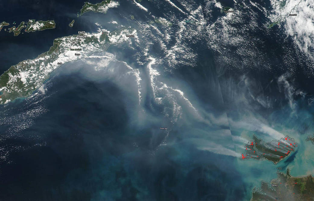
Satellite imagery revealed plumes of smoke generated from several fires burning on the Tiwi Islands in the Northern Indian Ocean reached East Timor. NASA-NOAA’s Suomi NPP satellite passed overhead on June 19 and provided a visible picture of the event.
The Tiwi Islands are part of Australia’s Northern Territory, Australia. They lie in the Timor Sea, about 50 miles (80 km) north of Darwin. The Tiwi Islands consist of Melville Island, Bathurst Island and 9 other smaller and uninhabited islands.
On the islands, agricultural burning is an important land management tool. The Tiwi Island Fire Council noted on their website, “The tropical savannas of northern Australia are among the most fire-prone ecosystems on Earth, with up to half of many savanna landscapes, including the Tiwi Islands, being burnt each year. Fire plays a key role in maintaining the open vegetation structure that most savanna plants and animals require. However, there is concern that fire frequency in some areas is too high, and that this is having a negative impact on biodiversity.”
The VIIRS or Visible Infrared Imaging Radiometer Suite scanning radiometer instrument aboard Suomi NPP provided a visible image that showed light brown streams of smoke from burning fires were blowing from the Tiwi Islands (bottom right corner on image) to the northeast across the Timor Sea. The image showed a large stream of smoke reached the nation of East Timor (top left in image).
East Timor, also known as Timor-Leste is a southeastern Asian nation occupying half the island of Timor. West Timor, the other half of the island is part of Indonesia’s East Nusa Tenggara Province.
Image credit: NASA Worldview, Earth Observing System Data and Information System (EOSDIS).
Text credit: Rob Gutro, NASA’s Goddard Space Flight Center, Greenbelt, Md.


