February has just begun and already weather extremes are being seen throughout the country of Chile. In the northern part of Chile one of the world’s driest deserts is flooding and in the south some of the planet’s wettest woodlands are burning.
Rains in the Andes have led to water pouring into the Atacama desert flooding out houses and roads. This is an area which is normally one of the driest places on Earth. Now a 60m (196ft) waterfall that had run dry for 10 years has been reactivated by the flooding. In the south, record breaking temperatures have sparked forest fires burning thousands of hectares of land and forcing the government to declare disaster areas. More than 600 forest fires are raging through 9,500 hectares (23,475 acres) of land, an increase from the year before. Besides high temperatures, low humidity, high winds and drought conditions there is a man-made element to the reason these wildfires are so large. Non-native pine and eucalypt forests have been planted to supply pulp and timber mills in central Chile. More fuel (and more flammable fuel) to burn equates to larger fires. This finding was made by scientists at Montana State University in 2018.
According to the World Meteorological Organization (WMO) extreme weather changes in early 2019 in the southern hemisphere, caused heat records to tumble in Chile. A weather station in the capital Santiago set a new record of 38.3°C (100.94F) in January. In other parts of central Chile, temperatures topped 40°C (104F), according to Meteo Chile. Heat gripped Patagonia in February, and for the first time ever Porvenir and Puerto Natalaes in the southern tip of the country exceeded 30°C (86F). Coyhaique reached a new record of 35.7°C (96.3F) and Cochrane 36.1°C (97F).
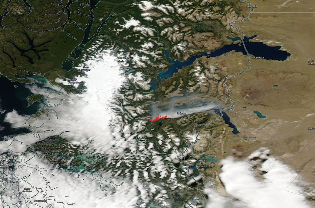
In this image captured by the MODIS instrument on the Aqua satellite on Feb. 12, 2019, fires are burning near the city of Cochrane. Each hot spot, which appears as a red mark, is an area where the thermal detectors on the MODIS instrument recognized temperatures higher than background. When accompanied by plumes of smoke, as in this image, such hot spots are diagnostic for fire. The smoke released by any type of fire (forest, brush, crop, structure, tires, waste or wood burning) is a mixture of particles and chemicals produced by incomplete burning of carbon-containing materials. All smoke contains carbon monoxide, carbon dioxide and particulate matter or soot. Image Courtesy: NASA Worldview, Earth Observing System Data and Information System (EOSDIS). Caption: Lynn Jenner with information from WMO


