


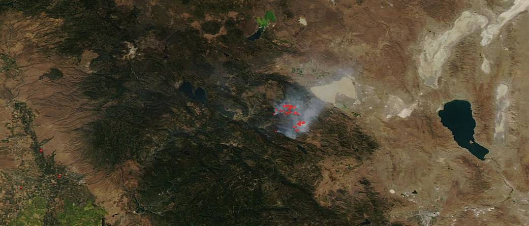
California’s Walker Fire, located about 11 miles east of Taylorsville, California, continues to grow within the Plumas National Forest. This fire has been burning since Sep. 04, 2019 and was first reported on NASA’s Fire and Smoke page on Sep 10, 2019. Since then the fire has grown to 50,730 acres and as of Sep. 13 is 32 percent contained. The cause of the blaze is still under investigation. NASA’s Aqua satellite captured this natural-color image of the fire on Sep. 12, 2019 using the VIIRS instrument (Visible Infrared Imaging Radiometer Suite) on NASA/NOAA’s Suomi NPP satellite to record the heat signatures. The smoke that is rising from the “hot spots” is blowing northeastward over Honey Lake. The weather concerns with regards to the fire include afternoon southwest winds along the ridge tops which will range from 7 and 13 mph (with gusts up to 20 mph) and southwest slope winds which will become northwest ranging from 3 and 8 mph (with gusts up to 14 mph). Winds are always critical when fighting fires because sudden wind changes can quickly turn the direction of the fire and put firefighters and structures in immediate danger. Winds can also push fires along and across roadways and other barriers causing a contained fire to travel beyond the containment lines.
NASA’s Earth Observing System Data and Information System (EOSDIS) Worldview application provides the capability to interactively browse over 700 global, full-resolution satellite imagery layers and then download the underlying data. Many of the available imagery layers are updated within three hours of observation, essentially showing the entire Earth as it looks “right now.” This satellite image was collected by NASA’s Aqua satellite on Sep. 12, 2019. Actively burning fires, detected by VIIRS thermal bands, are shown as red points. Image Courtesy: NASA Worldview, Earth Observing System Data and Information System (EOSDIS). Caption: Lynn Jenner with information from Inciweb.