


![Request for Information – Potential [Placeholder for Prize]](https://assets.science.nasa.gov/dynamicimage/assets/science/missions/a-step/FFR_Earth_Background_20251120%20.png?w=1024)


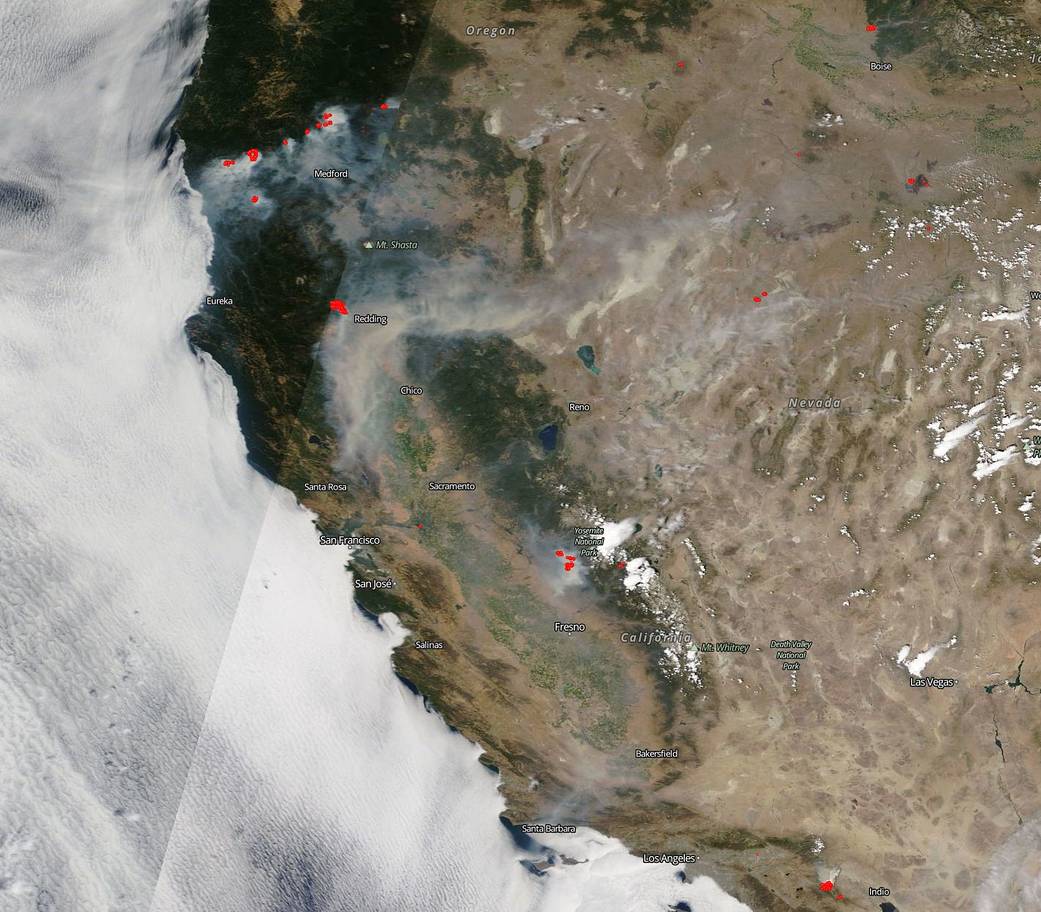
NASA’s Terra satellite captured this image of the west coast of the United States showing the breadth of the fire issues plaguing that area of the country. From Oregon and the fires around Medford, to the huge smoke plume and fire around Redding, to the Ferguson fire near Yosemite, the whole of the western coast looks like it is on fire. There’s even a small fire south of Los Angeles that can be seen at the very bottom edge of the image.
The fires around Medford are the Garner Complex fire began in Oregon on July 15, 2018 sparked by a spate of lightning strikes from thunderstorms. The complex is now 21,443 acres in size and is 25% contained. Weather concerns still surround the firefighting methods with regards to the Garner Complex include the following from Inciweb: “Northerly winds cleared the smoke away from the incident, and as a result, Thursday was much hotter and drier than previous days. High temperatures ranged from the mid-90s on the ridges to near 105 in the valleys. Humidities were generally in the teens with the minimums down as low as 11%. In addition, very dry air moved in aloft, and the Haines index rose to a 5. These combination of factors resulted in critical fire weather conditions Thursday. Conditions will improve Thursday night, but temperatures will be warm with only moderate humidity recoveries at best. Similar critical conditions are expected Friday.”
The fire around Redding, CA called the Carr Fire began on July 23 with a lightning strike. The fire quickly spread and is currently 44,450 acres in size and only 3% contained. This dangerous fire has already destroyed 65 structures and 55 other structures are being threatened. There are many mandatory evacuations in place and more information on that can be found on the Cal Fire info page. Once again the weather conditions continue to stoke the fire. Firefighting efforts have been hampered overnight (7/26) due to extreme fire behavior and challenging wind conditions. Continued hot dry weather is forecasted for the remainder of the week with triple digit temperatures. Hot, dry, low humidity and winds are the conditions that just make fires explode and grow.
The Ferguson fire has been in the news since its beginning on July 13 and it’s unknown what the origin of the fire was. To date, the fire has consumed 45,911 acres and is 29% contained. The mandatory evacuations include Yosemite Valley and Wawona areas, as well as the Mariposa Grove of Giant Sequoias. A heat advisory is in effect today, Friday, July 27, 2018 which will impact firefighters and will give new life to the fire. The hot, dry, and windy conditions make it difficult to contain the fire.
This image was captured by NASA’s Terra satellite on July 26, 2018. Actively burning areas, detected by MODIS’s thermal bands, are outlined in red. NASA image courtesy NASA/Goddard Space Flight Center Earth Science Data and Information System (ESDIS) project. Caption: Lynn Jenner with information from Inciweb and Cal Fire.