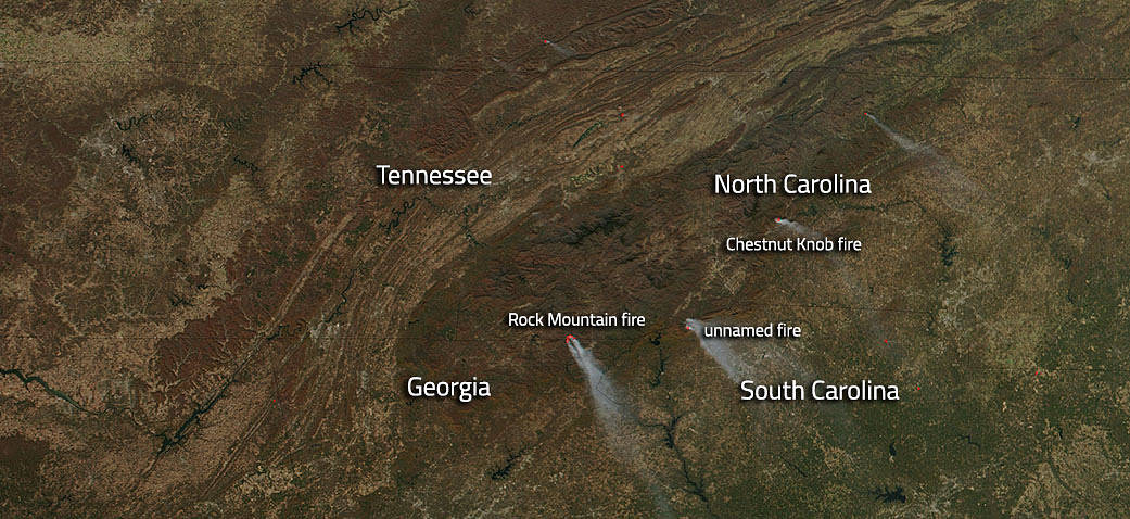
NOAA/NASA’s Suomi NPP satellite captured this image of the fires that continue to blaze in the southeastern United States with no end in sight. There are several fires visible. Two are fires that are listed on the Inciweb site that keeps track of fires across the U.S. One is a fire that doesn’t appear on either the Inciweb site or the GeoMAC wildfire viewer site and may not have been discovered as yet or may not have been reported to national authorities. The two fires that are named are the Chestnut Knob fire and the Rock Mountain fire.
The Chestnut Knob fire began on November 06, 2016. Its cause is still under investigation. The fire has grown to 6,424 acres in size and is 40% contained. In the forecast is very low humidity and winds would could serve to flame the fire and help it to spread. Firefighters are continuing to hold the fire line in anticipation of the weather event.
The Rock Mountain fire began on November 09, 2016 and was human caused. Currently the fire is 11,287 acres in size and is 30% contained. Unfortunately there is a high potential for extreme fire behavior from winds, low humidity and extremely dry fuels. The breezy conditions in the area continued to hamper firefighter efforts to control the perimeter. Wind gusts of 20-25 miles per hour, relative humidity minimums near 10%, and lack of meaningful rainfall in over three months are making extinguishing this fire very difficult.
NASA’s Suomi NPP satellite collected this natural-color image using the VIIRS (Visible Infrared Imaging Radiometer Suite) instrument on November 20, 2016. Actively burning areas, detected by MODIS’s thermal bands, are outlined in red. NASA image courtesy Jeff Schmaltz LANCE/EOSDIS MODIS Rapid Response Team, GSFC. Caption by Lynn Jenner with information from Inciweb.


