


You are at what seems to be the edge of nowhere and disaster strikes. Your plane crash-landed in the wilderness. Or you encountered life-threatening injuries while hiking on a remote mountain. Or your boat is adrift after being battered during a severe storm. What then?
It is routine to tote a mobile phone for times of trouble and distress – but that doesn’t work in mountains or at sea. Even satellite phones can’t reliably get a connection swiftly or offer precise location information in an emergency. What then?
NASA’s role in search and rescue, based out of NASA’s Goddard Space Flight Center in Greenbelt, Maryland, is largely behind the scenes to develop the next generation of rescue technology. Currently, the most reliable emergency beacon that is also available for public use in an emergency, is one that connects to an international satellite system that provides distress alert and location information to assist search and rescue operations even from the remotest regions of Earth.

Credits: NASA Goddard/Bill Hrybyk

This international, humanitarian satellite-based search and rescue system, in operation since 1982, was started by the United States, Canada, France and Russia, and now includes members from 43 countries and organizations. Known by the acronym COSPAS-SARSAT, signals of beacons operating on 406 Megahertz (MHz) channels are detected and located with a high degree of accuracy. There are other emergency beacons on the market, but only the emergency beacons operating on the 406 MHz channel take advantage of the COSPAS-SARSAT international response system.
The U.S. search and rescue program is a partnership with the National Oceanic and Atmospheric Administration (NOAA), the U.S. Coast Guard and the U.S. Air Force, with NASA providing the lead on technical support and development of technological improvements.
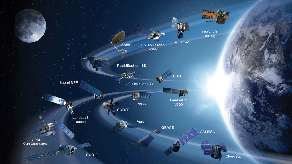
The current COSPAS-SARSAT system uses instruments placed on weather satellites operating in low-Earth (LEO) and geosynchronous (GEO) orbit. LEO spacecraft orbit Earth multiple times a day and are used to calculate the position of a beacon. However, a satellite may not be in position to pick up a distress signal the moment a user activates the beacon. Delays of several hours are possible, especially near the equator.
Meanwhile, geosynchronous weather satellites orbit above Earth in a fixed location over the equator. Although these satellites provide continuous visibility of much of Earth, they can only independently locate a beacon where the location is encoded in the beacon’s message from an internal navigation receiver.
The next generation COSPAS-SARSAT system will utilize satellites in the medium-altitude Earth orbit (19,000 to 24,000 kilometers or 12,000 to 15,000 miles) and improve beacon technology. When fully operational by the end of the decade, this new system will allow each distress message from a beacon to be relayed at the same time by several satellites to several ground antennas, allowing the system to provide timely beacon detection and location.
“NASA developed and tested the proof-of-concept ground station for the medium-altitude satellite system. This new system will have full-Earth coverage and provide near-instantaneous detection and location of people in distress using the COSPAS-SARSAT beacons,” said Lisa Mazzuca, NASA Search and Rescue mission manager at Goddard.
NASA is also working to develop more robust beacon technology. There are currently three types of emergency beacons: Personal use, Personal Locator Beacons; Maritime Emergency Position Indicating Radio Beacons; and Aviation Emergency Locator Transmitters.
“NASA is innovating the beacon technology needed to improve the location accuracy by an order of magnitude. This new technology will increase lives saved by enabling rescuers to decrease their search radius, which decreases the amount of time to get to a victim. This ultimately raises the probability of a successful rescue,” Mazzuca said.
Besides the improved location, NASA is aiming to improve beacon performance. For example, beacons for aviation use are designed to activate during an airplane crash. To study what happens to the beacons in an airplane crash, the NASA search and rescue office has researchers based out of NASA’s Langley Research Center in Hampton, Virginia, to crash a series of airplanes. The goal is to assess current beacon vulnerabilities and provide improvement recommendations.
The first crash test, conducted July 1, simulated a controlled airplane emergency landing on a highway or runway. The plane, equipped with two crash test dummies, fell at 72 feet per second onto a concrete surface. Sensors inside the plane collected 64 channels of data, while a total of 40 cameras recorded the crash.
Credit: NASA
The NASA research team is also working to miniaturize the beacon for use in future human space missions to Mars. Plans are for astronauts aboard the Orion spacecraft to carry a personal-use beacon in their pocket. This innovation will provide the order of magnitude location accuracy improvement and increased detection probability to astronauts separated from their capsule after landing.
Related Links
- NASA’s Search and Rescue Mission Office
- NOAA: Search and Rescue Satellite Aided Tracking
- Cospas-Sarsat: International Satellite System for Search and Rescue
- NASA’s Orion spacecraft website
- Feature Story: “Crash Test Assesses Plane Emergency Locator Transmitters” (July 2, 2015)
- Feature Story: “Taking the ‘Search’ out of Search and Rescue” (Sept. 2, 2010)
- Feature Story: “Sailor Reflects on NASA Technology That Saved His Life” (May 24, 2010)
By Audrey Haar
NASA’s Goddard Space Flight Center, Greenbelt, Md.