


Tracking gold mining activity and deforestation in the Amazon in near real-time using satellite-based Earth observations is now possible thanks to a collaboration between Peru, NASA and the United States Agency for International Development (USAID). The service is an effort by SERVIR-Amazonia, a joint initiative between NASA and USAID, which boosts environmental resilience and decision-making around the world. Through its network of regional hubs, SERVIR works with local decision makers to solve issues by using publicly available satellite imagery, geospatial data, and analysis tools.
The Peruvian government’s Ministry of Environment (MINAM) says that by using NASA satellite data, through SERVIR-Amazonia, it will better be able to eradicate illegal mining and to monitor the gold mining that the government allowed through mining concession.
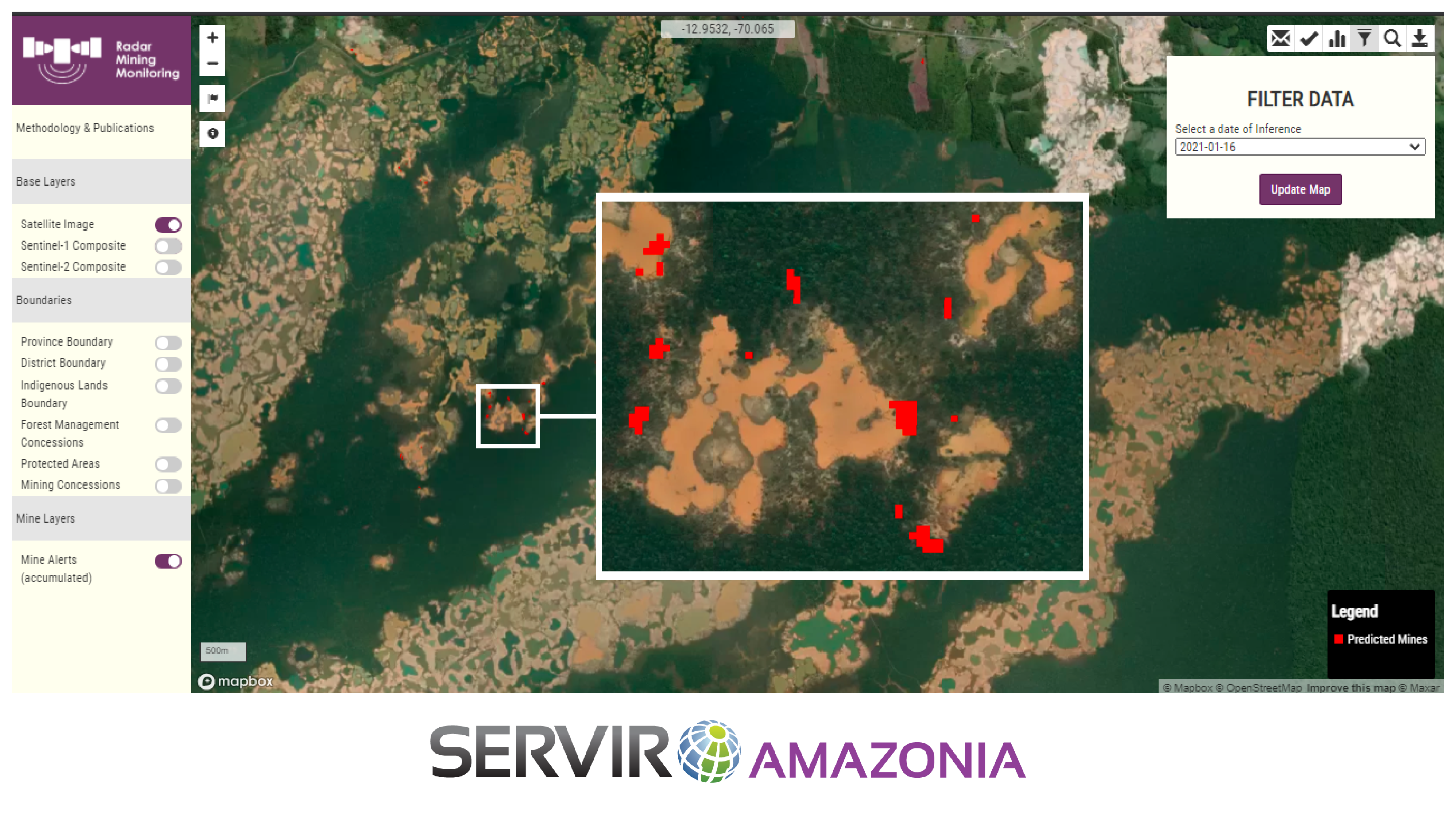
Key information about gold mining is available via SERVIR and Amazonia’s Radar Mining Monitoring Tool (RAMI). It uses C-band synthetic aperture radar (SAR) observations from the European Space Agency’s Copernicus Sentinel-1 satellite and freely available high-resolution Planet data provided by the Norwegian International Climate and Forest Initiative (NICFI). SAR sends and then receives back successive pulses of radio waves sent to the Earth’s surface, this allows it to uncover very small changes in the position of features of the Earth’s surface. Because mining activities changes the Earth’s surface in ways that can be distinguished from naturally occurring changes, SAR can indicate areas where gold mining may be happening.
“The novelty of using synthetic aperture radar or SAR in a near-real time detection system in the Amazon is unique,” said Sidney Novoa, ACCA’s director for GIS & Technology Applied for Conservation. “Because radar penetrates through clouds, it makes it possible to generate and obtain consistent and frequent information on gold mining areas year-round.” Combining the SAR data with the high-resolution data of Earth allows people to monitor areas deep within the Amazon forest.
The lead developer of the service is the Peruvian non-profit group Conservación Amazónica (ACCA). A similar NASA and USAID project is in use in Africa where the SERVIR-West Africa hub also monitors gold mining, and so the two SERVIR hubs collaborated to compare notes on their similar challenges of illegal mining and deforestation.
“This is a step towards protecting the Peruvian Amazon’s climate, clean water, and rich ecological heritage. This will also continue to help to advance scientific diplomacy between nations to address major global challenges,” said Sandra Cauffman, deputy director of NASA’s Earth Science Division. “This project would not have been possible without experts from across South America, satellite data from our European colleagues, and knowledge sharing from similar efforts in West Africa.”
“This is a clear example of SERVIR in action, combining state-of-the-art methods with real needs on the ground,” said Africa Flores, science coordination lead for NASA SERVIR-Amazonia.
In the Amazonia, SERVIR is implemented by the Alliance of Bioversity International and the International Center for Tropical Agriculture (CIAT) and a network of local and international partners serving the Amazon region, including the ACCA, the main developer of the project; as well as the Spatial Informatics Group (SIG), a private company; the Institute for Forest and Agriculture Management and Certification (IMAFLORA); and Fundación EcoCiencia.
In the future, the RAMI gold mining tool will include next-generation data from NASA’s Earth System Observatory. Among the first integrated parts of this new set of Earth-focused missions is NASA’s partnership with the Indian Space Research Organisation (ISRO) which brings together two different kinds of radar systems. One of the observatory’s first missions is NISAR (NASA-ISRO synthetic aperture radar) which will produce L-band data that penetrates further into the canopy cover and will complement the deforestation alerts from both SERVIR gold mining tracking systems. Novoa adds that another unique aspect of this project is its focus on local needs in Peru.
“The bottom-up approach in which regional scientists from ACCA, together with government stakeholders is unique,” said Novoa. “Collaborating to develop a detection system fulfills targeted needs to halt the negative implications of illegal gold mining in the region.”