


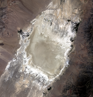
The Bureau of Land Management has approved NASA’s request to withdraw 22,634 acres of land in Railroad Valley (RRV), Nevada, from public and private use, preserving the land for a 20-year period for calibrating Earth-observing satellites.
Railroad Valley is a dry lakebed with land characteristics uniquely suited for calibrating NASA’s Earth-observing satellites, which provide vital and often time-critical information touching every aspect of life on Earth. The area is the only location in the United States with all the required qualities for satellite calibration due to the lakebed being large, flat, free of vegetation, of a consistent surface color, undisturbed, easy to access, and with good visibility from space. Altogether, these qualities make RRV a true national asset. This land withdrawal protects the area from activities that could change the surface conditions, ensuring NASA can continue delivering accurate information about our home planet for the benefit of all.
Since 1993, NASA has relied on RRV for conducting ground-based calibration of satellite instruments. This calibration is critical to ensure data returned is accurate, which in turn lends trust and credibility to the science that informs policy and decision-making.
Examples of Earth Science instruments that rely on the playa include those on NASA’s Aqua, Terra, Landsat, OCO-2 & OCO-3, Suomi-NPP, and EMIT missions. The region is also going to be critical for calibration of next generation Earth-observing satellites. Information received from these satellites guides actions related to weather, agriculture, food security, water, urban planning, climate, transportation, disaster preparedness and emergency response.
The National Oceanic and Atmospheric Administration and the U.S. Geological Survey as well as international and commercial partners also rely on RRV for satellite operations, underscoring the need to protect and preserve this national asset.
NASA has worked with the BLM since 2018 to determine the best way forward to preserve RRV for satellite calibration. At BLM’s recommendation, NASA submitted an application to withdraw the land from public use in July 2019. The BLM published a Federal Register Notice of Proposed Land Withdrawal April 29, 2021, which in turn launched a 90-day public comment period. Following the public comment period, NASA conducted an Environmental Assessment as part of its final land withdrawal application package.
The land withdrawal application was approved by BLM and effective beginning April 27, 2023.
Media Contact:
Jeremy Eggers
jeremy.l.eggers@nasa.gov


