


Scientists at NASA’s Langley Research Center in Hampton, Virginia, are breaking out their 3D glasses — not to watch the latest blockbuster movie, but to get a more detailed look at blockbuster storm clouds, and ultimately, a better understanding of severe weather.
You can get the same immersive view if you have your own pair of red-blue 3D glasses.
Following a severe storm outbreak that brought large hail, high winds and tornadoes to parts of Texas and Oklahoma on April 23 and 24, Langley scientists Kris Bedka and Konstantin Khlopenkov collaborated to create a 3D composite loop of satellite imagery collected by the National Oceanic and Atmospheric Administration’s GOES-17 and GOES-16 satellites (visible above). GOES-17 is in a geostationary orbit (high Earth orbit that allows satellites to match Earth’s rotation) southeast of Hawaii and GOES-16 is in a geostationary orbit approximately due south of Virginia’s Hampton Roads region.
Though the method for achieving the 3D effect was fairly complex, in the simplest terms it involved applying the western satellite visible wavelength imagery to the red spectrum and the eastern imagery to the blue-green spectrum, then overlaying those images into a single image, or anaglyph, that viewers can see with traditional red-blue 3D glasses.
“Combining imagery from multiple angles gives us the third dimension we don’t have with just one satellite,” said Bedka.
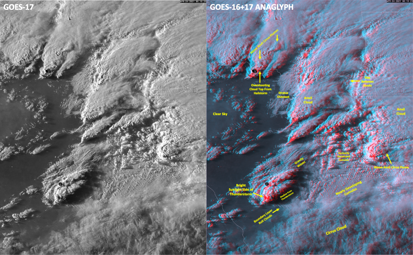
Since the two satellites collect images as often as every 30 seconds, and within just a few seconds of one another, combining imagery this way could be a game changer for researchers who study thunderstorms.
“Pairing the high-resolution 3D view with the very rapidly updating imagery really opens up a lot of doors for us in unraveling storm dynamical processes and how they lead to severe weather,” said Bedka.
The detailed 3D perspective also gives scientists a more accurate way to measure cloud height, which they currently do through a bit of inference by taking satellite-observed cloud temperature and matching it to weather prediction models, which provide gridded height and temperature profiles throughout the world. This method works well most of the time, but weather models do not always correctly simulate temperatures near the tops of powerful storms. By also incorporating the best possible 3D rendering of the clouds at the highest possible time intervals, scientists can track patterns visually and better unravel severe-weather processes. Bedka and Khlopenkov are currently working on an algorithm for automating cloud height based on the 3D imagery.
That improved ability to measure cloud height will come in handy this summer when Bedka is scheduled to participate in a NASA airborne science campaign called Dynamics and Chemistry of the Summer Stratosphere (DCOTSS). The study will look at intense thunderstorms over the U.S. that loft moisture and ice plumes into the stratosphere. As part of that study, NASA’s ER-2 high-altitude research aircraft will measure the composition of those plumes in an effort to help scientists better understand how they affect radiative and chemical properties of the stratosphere. The 3D composites should give DCOTSS researchers a better idea of the exact heights of the storms they measure.
In the meantime, put on your 3D glasses — if you have them — and see weather satellite imagery like you’ve never seen it before.
In addition to the YouTube versions, you can download both satellite loops and watch them on your computer or device:
GOES Satellite 3D Composite
GOES Satellite 3D Composite 2
Joe Atkinson
NASA Langley Research Center