![Request for Information – Potential [Placeholder for Prize]](https://assets.science.nasa.gov/dynamicimage/assets/science/missions/a-step/FFR_Earth_Background_20251120%20.png?w=1024)


Scientists tap into an array of imagers aboard the six-wheeled explorer to get a big picture of the Red Planet.
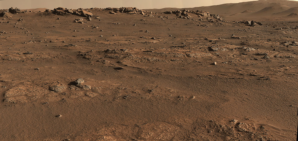
NASA’s Perseverance rover has been exploring Jezero Crater for more than 217 Earth days (211 Martian days, or sols), and the dusty rocks there are beginning to tell their story – about a volatile young Mars flowing with lava and water.
That story, stretching billions of years into the past, is unfolding thanks in large part to the seven powerful science cameras aboard Perseverance. Able to home in on small features from great distances, take in vast sweeps of Martian landscape, and magnify tiny rock granules, these specialized cameras also help the rover team determine which rock samples offer the best chance to learn whether microscopic life ever existed on the Red Planet.
Altogether, some 800 scientists and engineers around the world make up the larger Perseverance team. That includes smaller teams, from a few dozen to as many as 100, for each of the rover’s cameras and instruments. And the teams behind the cameras must coordinate each decision about what to image.
“The imaging cameras are a huge piece of everything,” said Vivian Sun, the co-lead for Perseverance’s first science campaign at NASA’s Jet Propulsion Laboratory in Southern California. “We use a lot of them every single day for science. They’re absolutely mission-critical.”
The storytelling began soon after Perseverance landed in February, and the stunning images have been stacking up as the multiple cameras conduct their scientific investigations. Here’s how they work, along with a sampling of what some have found so far:
The Big Picture
Perseverance’s two navigation cameras – among nine engineering cameras – support the rover’s autonomous driving capability. And at each stop, the rover first employs those two cameras to get the lay of the land with a 360-degree view.
“The navigation camera data is really useful to have those images to do a targeted science follow-up with higher-resolution instruments such as SuperCam and Mastcam-Z,” Sun said.
Perseverance’s six hazard avoidance cameras, or Hazcams, include two pairs in front (with only a single pair in use at any one time) to help avoid trouble spots and to place the rover’s robotic arm on targets; the two rear Hazcams provide images to help place the rover in the context of the broader landscape.
Mastcam-Z, a pair of “eyes” on the rover’s mast, is built for the big picture: panoramic color shots, including 3D images, with zoom capability. It can also capture high-definition video.
Jim Bell at Arizona State University leads the Mastcam-Z team, which has been working at high speed to produce images for the larger group. “Part of our job on this mission has been a sort of triage,” he said. “We can swing through vast swaths of real estate and do some quick assessment of geology, of color. That has been helping the team figure out where to target instruments.”
Color is key: Mastcam-Z images allow scientists to make links between features seen from orbit by the Mars Reconnaissance Orbiter (MRO) and what they see on the ground.
The instrument also functions as a low-resolution spectrometer, dividing the light it captures into 11 colors. Scientists can analyze the colors for clues about the composition of the material giving off the light, helping them decide which features to zoom in on with the mission’s true spectrometers.
For instance, there’s a well-known series of images from March 17. It shows a wide escarpment, aka the “Delta Scarp,” that is part of a fan-shaped river delta that formed in the crater long ago. After Mastcam-Z provided the broad view, the mission turned to SuperCam for a closer look.
The Long View
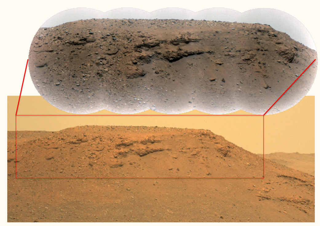
Scientists use SuperCam to study mineralogy and chemistry, and to seek evidence of ancient microbial life. Perched near Mastcam-Z on Perseverance’s mast, it includes the Remote Micro-Imager, or RMI, which can zoom in on features the size of a softball from more than a mile away.
Once Mastcam-Z provided images of the scarp, the SuperCam RMI homed in on a corner of it, providing close-ups that were later stitched together for a more revealing view.
To Roger Wiens, principal investigator for SuperCam at Los Alamos National Laboratory in New Mexico, these images spoke volumes about Mars’ ancient past, when the atmosphere was thick enough, and warm enough, to allow water to flow on the surface.
“This is showing huge boulders,” he said. “That means there had to have been some huge flash flooding that occurred that washed boulders down the riverbed into this delta formation.”
The chock-a-block layers told him even more.
“These large boulders are partway down the delta formation,” Wiens said. “If the lakebed was full, you would find these at the very top. So the lake wasn’t full at the time the flash flood happened. Overall, it may be indicating an unstable climate. Perhaps we didn’t always have this very placid, calm, habitable place that we might have liked for raising some micro-organisms.”
In addition, scientists have picked up signs of igneous rock that formed from lava or magma on the crater floor during this early period. That could mean not only flowing water, but flowing lava, before, during, or after the time that the lake itself formed.
These clues are crucial to the mission’s search for signs of ancient Martian life and potentially habitable environments. To that end, the rover is taking samples of Martian rock and sediment that future missions could return to Earth for in-depth study.
The (Really) Close-up
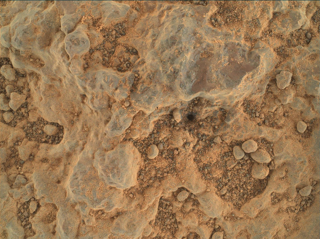
A variety of Perseverance’s cameras assist in the selection of those samples, including WATSON (the Wide Angle Topographic Sensor for Operations and eNgineering).
Located at the end of the rover’s robotic arm, WATSON provides extreme closeups of rock and sediment, zeroing in on the variety, size, shape, and color of tiny grains – as well as the “cement” between them – in those materials. Such information can lend insight into Mars’ history as well as the geological context of potential samples.
WATSON also helps engineers position the rover’s drill for extracting rock core samples and produces images of where the sample came from.
The imager partners with SHERLOC (Scanning Habitable Environments with Raman & Luminescence for Organics & Chemicals), which includes an Autofocus and Contextual Imager (ACI), the rover’s highest-resolution camera. SHERLOC uses an ultraviolet laser to identify certain minerals in rock and sediment, while PIXL (Planetary Instrument for X-ray Lithochemistry), also on the robotic arm, uses X-rays to determine the chemical composition. These cameras, working in concert with WATSON, have helped capture geologic data – including signs of that igneous rock on the crater floor – with a precision that has surprised scientists.
“We’re getting really cool spectra of materials formed in aqueous [watery] environments – for example sulfate and carbonate,” said Luther Beegle, SHERLOC’s principal investigator at JPL.
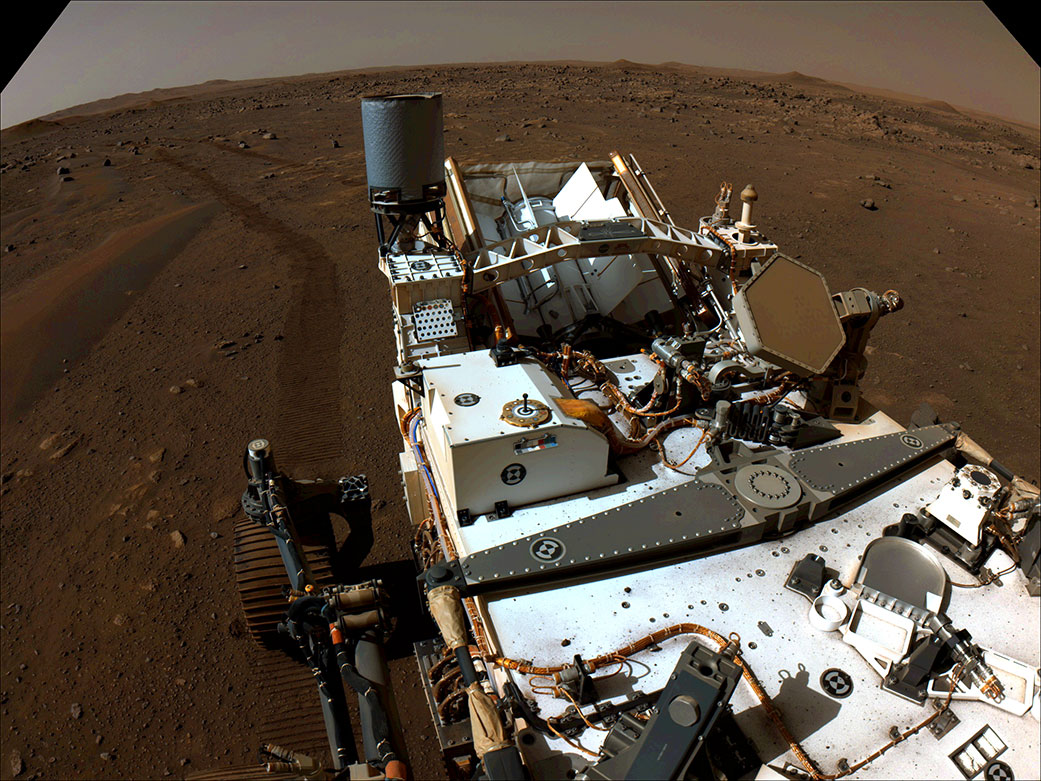
Engineers also use WATSON to check on the rover’s systems and undercarriage – and to take Perseverance selfies (here’s how).
Beegle says not just the strong performance of the imaging instruments, but their ability to endure the harsh environment on the Martian surface, gives him confidence in Perseverance’s chances for major discoveries.
“Once we get over closer to the delta, where there should be really good preservation potential for signs of life, we’ve got a really good chance of seeing something if it’s there,” he said.
More About the Mission
A key objective for Perseverance’s mission on Mars is astrobiology, including the search for signs of ancient microbial life. The rover will characterize the planet’s geology and past climate, pave the way for human exploration of the Red Planet, and be the first mission to collect and cache Martian rock and regolith (broken rock and dust).
Subsequent NASA missions, in cooperation with ESA (European Space Agency), would send spacecraft to Mars to collect these sealed samples from the surface and return them to Earth for in-depth analysis.
The Mars 2020 Perseverance mission is part of NASA’s Moon to Mars exploration approach, which includes Artemis missions to the Moon that will help prepare for human exploration of the Red Planet.
JPL, which is managed for NASA by Caltech in Pasadena, California, built and manages operations of the Perseverance rover.
For more about Perseverance:
DC Agle / Andrew Good
Jet Propulsion Laboratory, Pasadena, Calif.
818-393-9011 / 818-393-2433
agle@jpl.nasa.gov / andrew.c.good@jpl.nasa.gov
Karen Fox / Alana Johnson
NASA Headquarters, Washington
301-286-6284 / 202-358-1501
karen.c.fox@nasa.gov / alana.r.johnson@nasa.gov
Written by Pat Brennan
2021-199