


![Request for Information – Potential [Placeholder for Prize]](https://assets.science.nasa.gov/dynamicimage/assets/science/psd/solar/2023/09/s/solarsystem_0.jpg?w=1024)


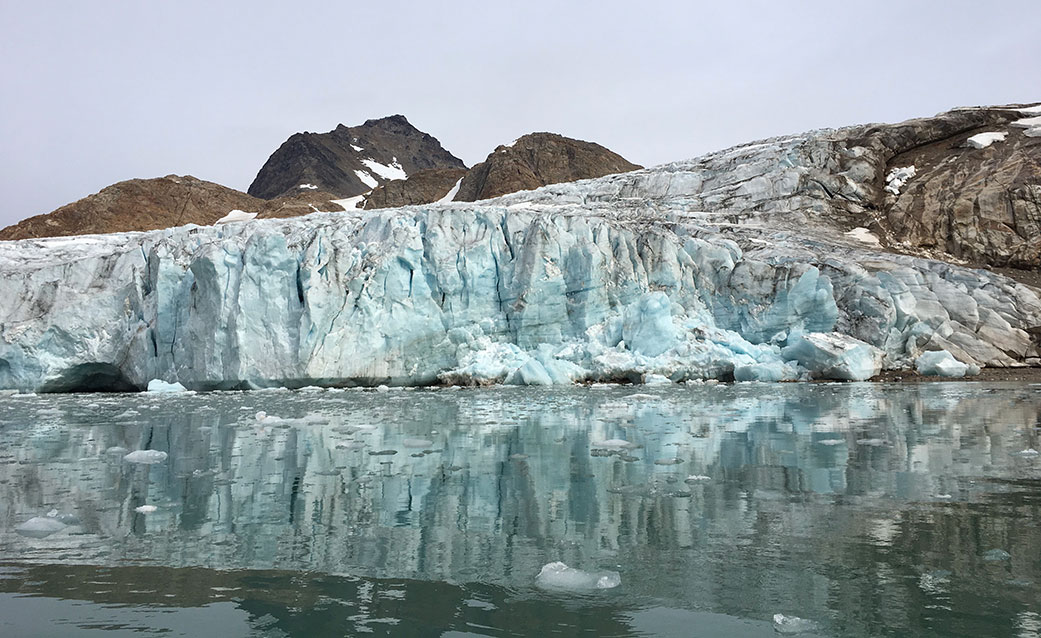
To learn how ocean water is melting glaciers, NASA’s Oceans Melting Greenland mission extensively surveyed the coastline of the world’s largest island.
The most important thing to remember about NASA’s Oceans Melting Greenland mission, which ended Dec. 31, 2021, may be its name: OMG proved that ocean water is melting Greenland’s glaciers at least as much as warm air is melting them from above. Because ice loss from Greenland’s ice sheet currently contributes more to the global rise of the oceans than any other single source, this finding has revolutionized scientists’ understanding of the pace of sea level rise in the coming decades.
These new, unique measurements have clarified the likely progress of future ice loss in a place where glaciers are melting six or seven times faster today than they were only 25 years ago. If all of Greenland’s ice sheet were to melt, global sea levels would rise by about 24 feet (7.4 meters).
But that’s just the tip of the iceberg in the story of this small plane- and boat-based mission. In six years of operations, OMG made the first scientific measurements along many miles of the most remote coastline in the Northern Hemisphere. The mission performed the most complete survey of the seafloor around Greenland’s coastline, including dozens of previously uncharted fjords (cliff-lined inlets clogged with icebergs from disintegrating glaciers), and measured how the ocean temperature changed from place to place, year to year, and top to bottom. To get this unique dataset, mission planes logged enough air miles around and over Greenland to circle the globe more than 13 times.
Preparation
More than 220 glaciers flow from Greenland into the ocean. Before OMG, scientists figured the ocean water swirling around and under these glaciers had to be contributing to their ice loss. But how much?
Satellite observations of sea surface temperature weren’t much help in answering that question. Around Greenland, the top layer of the ocean is extremely cold and not very salty, containing a lot of water from the Arctic, the freshest of oceans. A shallow glacier that only touches this layer melts slowly. But hundreds of feet below, the ocean is warmer and saltier. A deep-seated glacier is eaten away by the warmer water, losing ice four or five times as fast as a shallow one.
The only way to find out any glacier’s risk is to go to Greenland and measure the glacier and the seafloor and water in front of it. Scientists had been studying individual glaciers that way for years, but Josh Willis, principal investigator of OMG at NASA’s Jet Propulsion Laboratory in Southern California, wanted to get the complete picture: to measure all 220-plus glaciers for five years – the length of time available to missions funded by NASA’s Earth Ventures airborne research program.
“When we started to design OMG, we asked ourselves, ‘Can we do an experiment in five years that will tell us about the next 50?’” Willis said. Results have proved that they could. NASA even allowed them a sixth year of fieldwork to observe unexpected, rapid swings in water temperatures off Greenland’s west coast.
Operation
The mission’s first job was to map the seafloor around the island to see where deep, warm water can reach glaciers. A contractor completed most of the mapping using a research boat, and OMG Deputy Principal Investigator Eric Rignot of JPL and the University of California, Irvine led smaller surveys in following years to fill in missing sections.
To measure the ocean temperature and salinity down to the seafloor, Willis ran a summer airborne campaign that dropped about 250 probes each year into the ocean at strategic locations around the entire coastline. Six summers of flying over the remote Arctic may sound more like an adventure than a research project, but, Willis said, “It’s only an adventure in retrospect. While you’re in it, you have your head down and you’re working as hard as you can.” For the scientists, the data streaming into their computer from the probes was excitement enough.
The detailed maps and temperature data collected by OMG show that two to four times as many glaciers sit in water that is several degrees warmer than previously thought and, thus, are at higher risk than anyone knew. Researchers understood that about a third of Greenland’s glaciers account for half of its ice loss; OMG found that all of these culprits reach down into warm water. Climate models that don’t account for the warm water’s effects underestimate glacial ice loss by at least a factor of two – in other words, missing half the sea level rise from this source.
Collaboration
OMG’s groundbreaking data has influenced many kinds of Arctic studies besides oceanography. For example, Kristin Laidre of the University of Washington is an internationally known expert on narwhals, Arctic whales with a tusk-like protruding tooth. She and Ian Fenty, an OMG co-principal investigator at JPL, developed a project that benefits both marine biologists and oceanographers: a research cruise to place OMG probes and acoustic sounders that record the presence of narwhals in front of West Greenland glaciers.
The probe data provides a close-up view of how much ocean conditions can vary in a small area, and Laidre hopes that, in combination with the sounder data, it will help explain why certain glacier fronts are especially attractive to narwhals. “We biologists can get a better understanding of animals and populations by working with physical scientists,” she said, referring to the OMG team. “To have a group of scientists who want to collaborate is really great.”
Continuation
The end of the mission doesn’t mean the end of all new data from the Greenland ocean. In 2021, the team dropped a few longer-lived probes in areas where changes in ocean temperatures or circulation are not fully understood. These probes “winter over” below the surface, continuing to bob up and down through the water to collect data that will be read remotely when the ice melts next summer.
And scientists in many fields will continue to draw on OMG’s observations for their research. To date, about half of peer-reviewed journal articles using the data are written by researchers outside the mission’s science team – an unusually large portion. “We’re seeing a lot more science than we originally planned,” Willis said. “Those papers aren’t going to stop.”
Jane J. Lee / Andrew Wang
Jet Propulsion Laboratory, Pasadena, Calif.
818-354-0307 / 626-379-6874
jane.j.lee@jpl.nasa.gov / andrew.wang@jpl.nasa.gov
Written by Carol Rasmussen
2022-008