


NASA GPM Gets a Ton of Kilo
Credits: NASA Goddard Space Flight Center
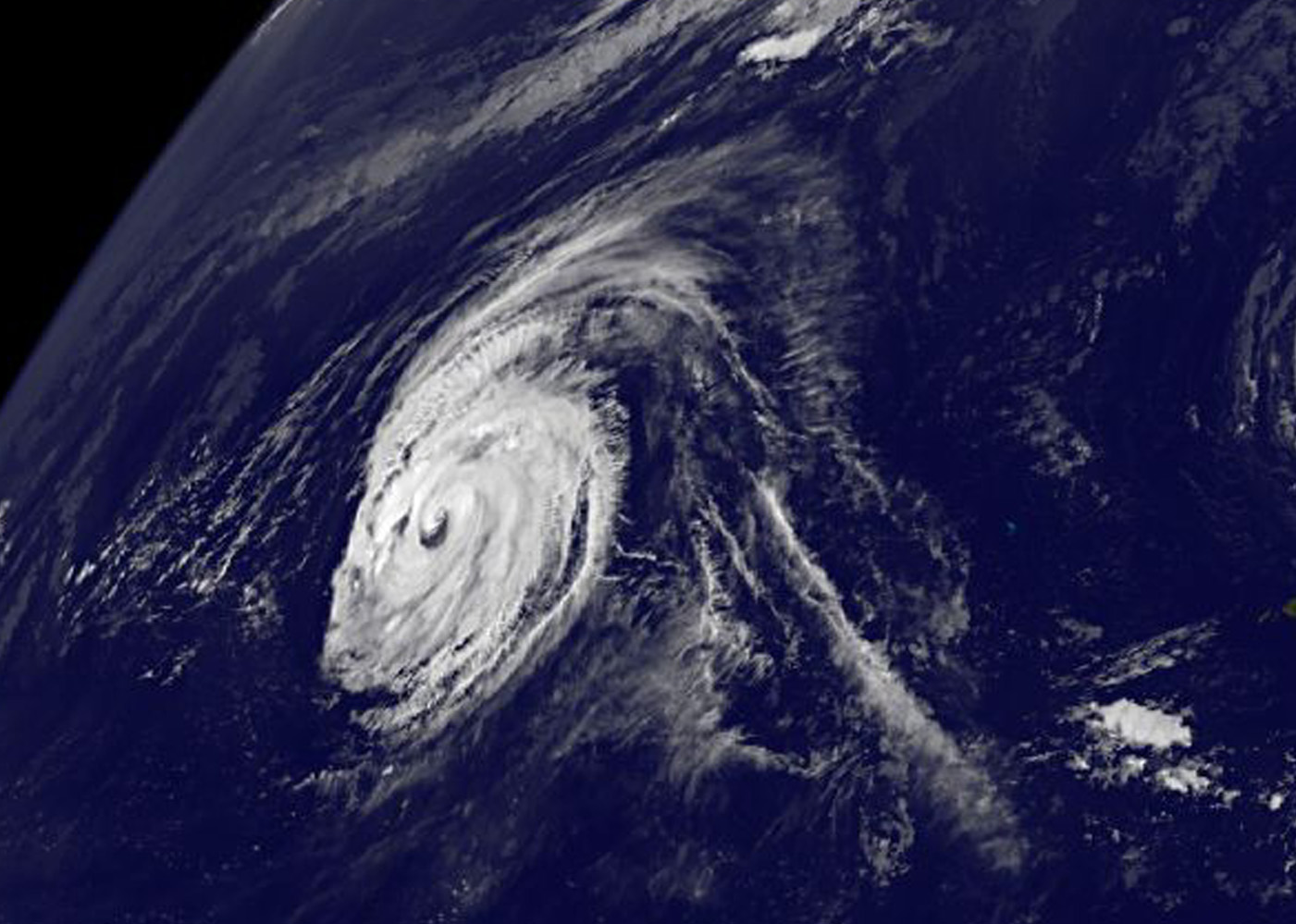
Sep. 11, 2015 – NASA Spots Kilo Becoming Extra-Tropical Near Hokkaido, Japan
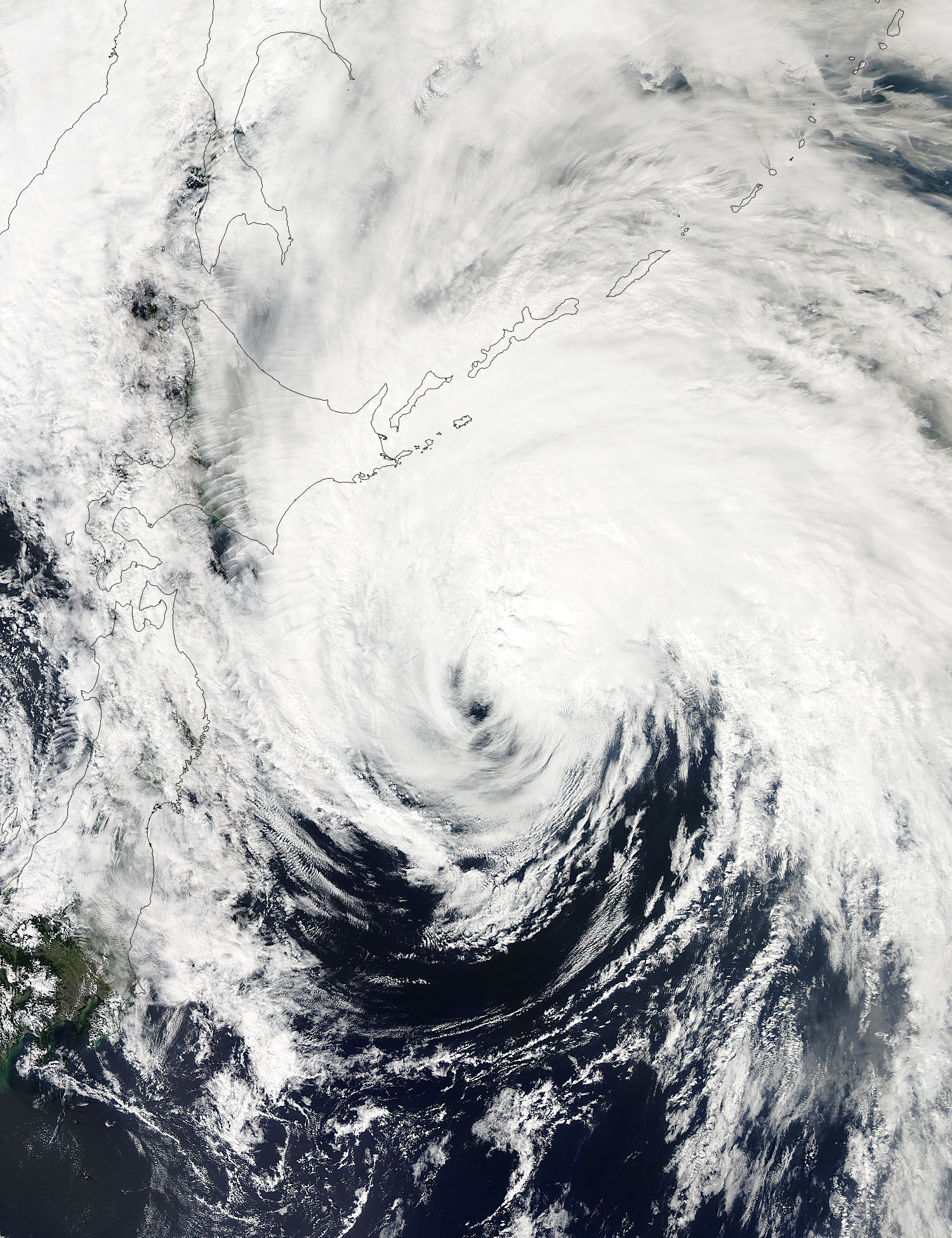
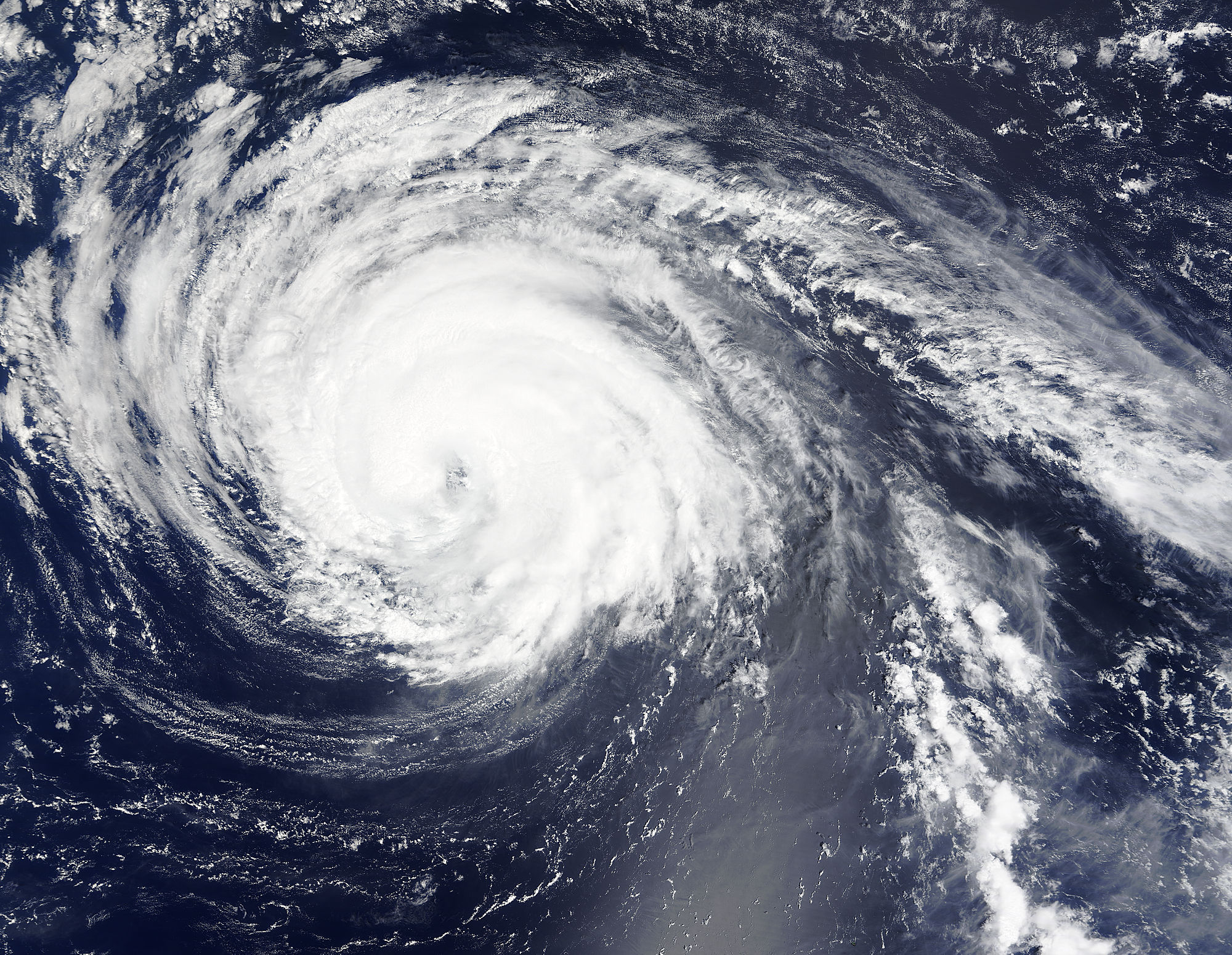
NASA’s Aqua satellite spotted Tropical Storm Kilo brushing the eastern side of Hokkaido, Japan early on September 11 as it was becoming extra-tropical.
At 03:35 UTC (11:35 p.m. EDT on Sept. 10) the Moderate Resolution Imaging Spectroradiometer or MODIS instrument aboard NASA’s Aqua satellite captured a visible image of Tropical Storm Kilo brushing northern Japan. The center of Kilo was east of northern Honshu (the largest island in Japan) and clouds and storms in Kilo’s northwestern quadrant were over the island of Hokkaido, Japan’s northernmost island. Kilo is a large storm with tropical-storm-force winds of 34 knots (39.1 mph/62.9 kph) or higher occurring up to 225 nautical miles (259.1 miles/417 km) from the center.
The Joint Typhoon Warning Center issued their final warning on the system at 0300 UTC on September 11 (11 p.m. EDT, Sept. 10), marking the end of the system after three weeks as a tropical cyclone. Kilo’s center was near 38.5 North latitude and 147.4 East longitude, about 309 nautical miles east-southeast of Misawa, Japan.
Kilo’s maximum sustained winds were near 45 knots (51.7 mph/83.3 kph) and it was moving to the north-northwest at 17 knots (19.5 mph/31.4 kph).
The Joint Typhoon Warning Center noted that Kilo is now tracking over sea surface temperatures of 77 degrees Fahrenheit (25 degrees Celsius). Tropical cyclones need sea surface temperatures of at least 26.6C/80F to maintain intensity and tropical characteristics. The JTWC noted that as Kilo continues moving north, sea surface temperatures will drop rapidly, helping the system transition to an extra-tropical storm.
Kilo is becoming an extra-tropical storm as it approaches the southern Kuril Islands. The islands are part of Russia’s Sakhalin Oblast region and are an archipelago that covers about 810 miles (1,300 km) from northern Japan to Kamchatka, Russia.
When a tropical cyclone becomes extra-tropical it has lost its “tropical” characteristics. According to the National Oceanic and Atmospheric Administration, the term “extra-tropical” implies both poleward displacement (it moves closer to the north or south pole depending on what hemisphere it is located in) of the cyclone and the conversion of the cyclone’s primary energy source from the release of latent heat of condensation to baroclinic (the temperature contrast between warm and cold air masses) processes. It is important to note that cyclones can become extra-tropical and still retain winds of hurricane or tropical storm force.
Kilo is expected to pass through the Kuril Islands and move into the Sea of Okhotsk by September 12 where it is forecast to dissipate.
Rob Gutro
NASA’s Goddard Space Flight Center
Sep. 10, 2015 – NASA Sees Tropical Storm Kilo Affected by Wind Shear
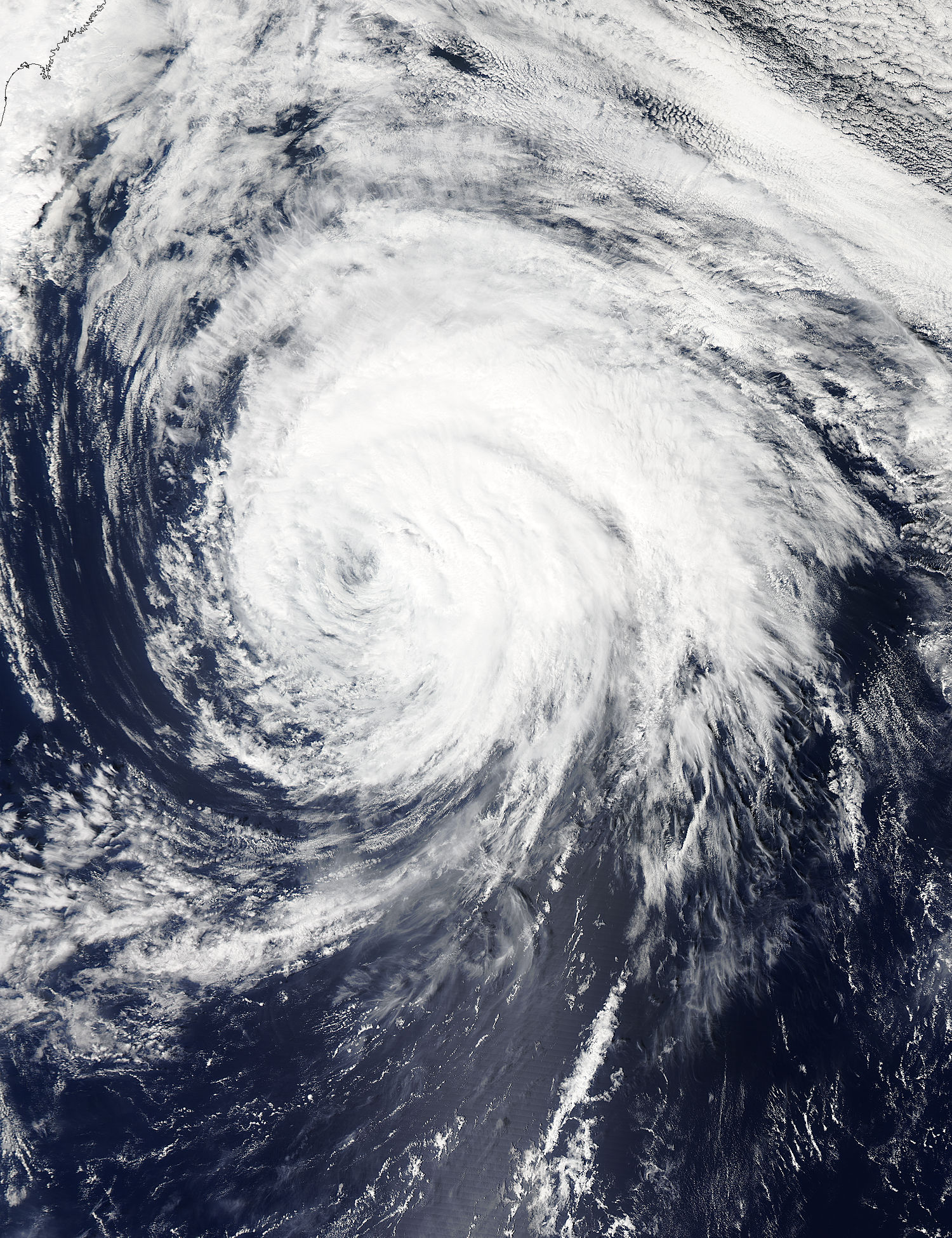
Strong vertical wind shear is taking its toll on the now weaker Tropical Storm Kilo in the Northwestern Pacific Ocean. Visible and infrared imagery from NASA’s Aqua satellite shows that southwesterly wind shear has been pushing the clouds and storms to the northeast of the storm’s center.
The Atmospheric Infrared Sounder or AIRS instrument that flies aboard NASA’s Aqua satellite gathers infrared data that reveals temperatures. When NASA’s Aqua satellite passed over Tropical Storm Kilo on September 9 at 1547 UTC (11:47 a.m. EDT), the AIRS data and showed some highest, coldest, strongest thunderstorms with cloud top temperatures near -63F/-53C were being pushed north and east of the center as a result of strong vertical wind shear.
On September 10, the Joint Typhoon Warning Center noted that animated enhanced infrared satellite imagery continues to indicate eroding deep convection displaced over the northern semi-circle of the system.
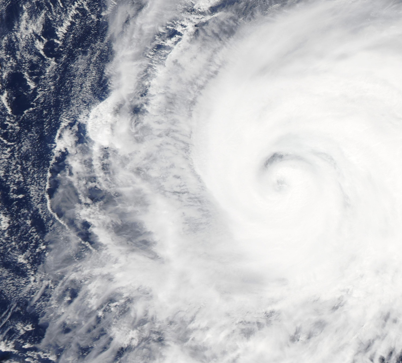
When NASA’s Aqua satellite passed over Kilo again on September 10 at 02:50 UTC (Sept. 19 at 10:50 p.m. EDT), the Moderate Resolution Imaging Spectroradiometer or MODIS instrument took a visible picture of the storm. The MODIS image showed that strong wind shear continued to push the clouds northeast of the center.
At 11 a.m. EDT (1500 UTC) the center of Tropical Storm Kilo was located near latitude 35.9 north and longitude 148.4 west. About 483 nautical miles (555.8 miles/894.5 km) southeast of Misawa Air Base, Japan. Kilo was moving toward the north-northwest near 13 knots (14.9 mph/24 kph) and is expected to turn toward the west-southwest on Sept. 9 and 10. Maximum sustained winds are near 50 knots (57.5 mph/ 92.6 kph).
Kilo was moving north-northwest and continues to weaken. Kilo is expected to become extra-tropical on September 11 off Hokkaido, Japan, the northernmost of Japan’s main islands.
Rob Gutro
NASA’s Goddard Space Flight Center
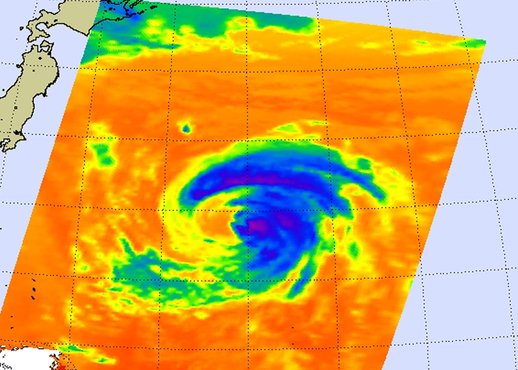
Sep. 09, 2015 – NASA’s RapidScat Sees Typhoon Kilo Hold Strength
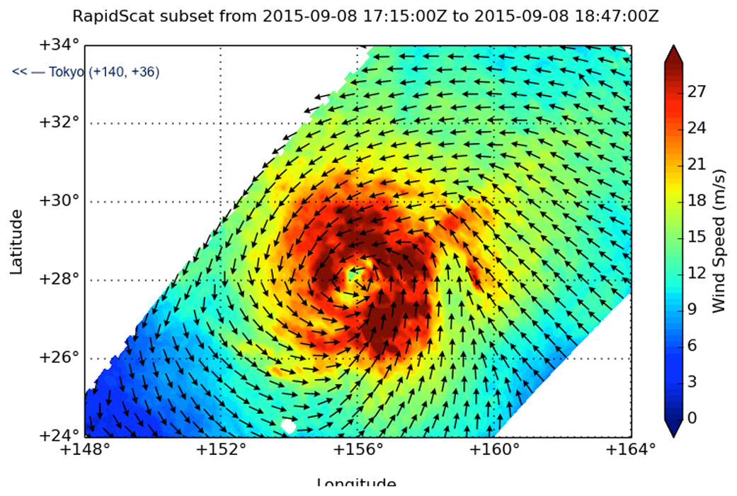
Typhoon Kilo is maintaining strength as it continues to move through the Northwestern Pacific Ocean. NASA’s RapidScat instrument measured the typhoon-force winds and the extent of tropical-storm force winds in the storm.
At 1500 UTC (11 a.m. EDT) on September 9, Typhoon Kilo’s maximum sustained winds were near 65 knots (75 mph/120.4 kph) making it a Category 1 hurricane on the Saffir-Simpson Scale.
It was centered near 30.8 North latitude and 152.5 East longitude, about 674 nautical miles east southeast of Narita Airport, Japan. Kilo was moving to the northwest at 14 knots (16.1 mph/25.9 kph).
RapidScat showed that tropical storm-force winds extended between 170 to 240 nautical miles (196.5 to 276.4 miles/314.8 to 444.8 km) from the center of circulation. RapidScat data showed that the strongest sustained winds surrounded the eye and were stronger than 30 meters per second (108 kph/67 mph). Kilo’s eye is about 9 nautical miles wide.
Infrared satellite imagery shows bands of thunderstorms continued to wrap in the slightly cloud-filled eye with some slight subsidence or sinking air on the western side of the system. Where the air sinks, clouds cannot form.
Kilo was moving northwest, along the southwestern edge of a western extension of a deep layered sub-tropical ridge (elongated area) of high pressure.
Forecasters at the Joint Typhoon Warning Center expect it to maintain current strength over the next day or so. Kilo is curving north and is forecast to transition to an extra-tropical storm as it moves into the Sea of Okhotsk.
Rob Gutro
NASA’s Goddard Space Flight Center
Sep. 08, 2015 – NASA Sees Typhoon Kilo Maintaining its Eye
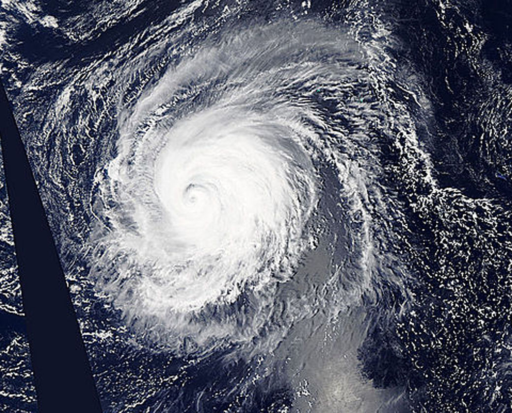
Typhoon Kilo continues to thrive in the Northwestern Pacific and imagery from NASA’s Terra satellite late on September 7 showed that the storm still maintained a clear eye.
The MODIS or Moderate Resolution Imaging Spectroradiometer instrument that flies aboard Terra provided a visible-light image of Kilo on September 7 at 23:50 UTC (7:50 p.m. EDT). The image showed thick bands of thunderstorms wrapping around the eastern and northern quadrants of the visible eye.
At 0900 UTC (5 a.m. EDT) on September 9, Typhoon Kilo had maximum sustained winds near 65 knots (74.8 mph/120.4 kph). Kilo is expected to strengthen to 75 knots (86.3 mph/ 138.9 kph) later in the day before weakening. It was centered near 26.8 North latitude and 158.5 East longitude, about 289 nautical miles northeast of Minami Tori Shima, Japan. Kilo was moving to the west-northwest at 18 knots (20.7 mph/33.3 kph).
The Joint Typhoon Warning Center noted that Kilo is expected to take more of a northerly track by September 10. Thereafter, Kilo is expected to become extra-tropical and curve to the northeast near the Kuril Islands in Russia’s Sakhalin Oblast region. The islands form an 808 mile (1,300 kilometer) volcanic archipelago that stretches northeast from Hokkaido, Japan, to Kamchatka, Russia.
For updated watches and warnings from the Japan Meteorological Agency, visit: http://www.jma.go.jp/en/warn/
Rob Gutro
NASA’s Goddard Space Flight Center
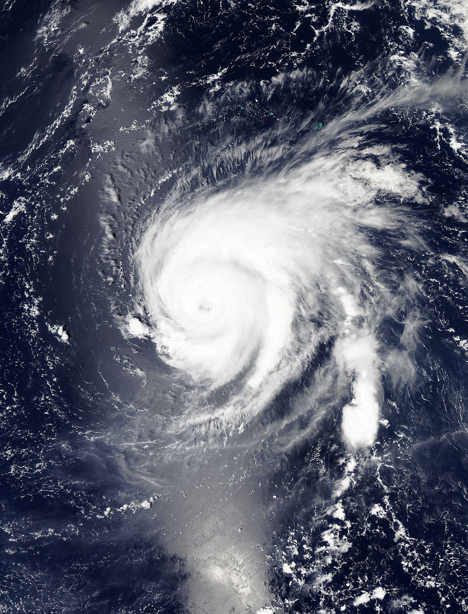
Sep. 04, 2015 – Typhoon Kilo’s Eye Gets a NASA Style Close-Up
NASA’s Aqua satellite got a close-up of Typhoon Kilo’s eye as it moved through the Northwestern Pacific Ocean.
The MODIS or Moderate Resolution Imaging Spectroradiometer instrument aboard NASA’s Aqua satellite zoomed into Typhoon Kilo’s eye on September 3. MODIS looked at the eye with a 250 meter (0.15 mile/273 yard) resolution close-up. The image showed an eye mostly covered by high clouds, however, the northern eyewall was visible.
At 1500 UTC (11 a.m. EDT) on September 4, 2015, Kilo’s maximum sustained winds were near 75 knots (86.3 mph/138.9 kph). It was centered near 23.4 North latitude and 175.7 East longitude, about 565 nautical miles (650 miles/1,046 km) east-northeast of Wake Island. Kilo was moving to the west at 6 knots (6.9 mph/11.1 kph).
The Joint Typhoon Warning Center (JTWC) expects Kilo re-strengthen as it moves through warm waters above 30 Celsius (85 Fahrenheit). JTWC expects Kilo to peak at 120 knots on Sept. 7 after passing Wake Island. After that peak weakening is forecast to being as the storm turns to the west-northwest. For updated forecasts, visit the JTWC website: http://www.usno.navy.mil/JTWC/.
Rob Gutro
NASA’s Goddard Space Flight Center
Sep. 03, 2015 – NASA’s Aqua Satellite Sees Typhoon Kilo Headed West
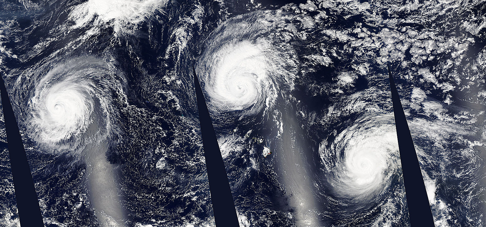
Typhoon Kilo is the westernmost tropical cyclone of a four storms in the Pacific Ocean basin on September 4. From west to east they include Typhoon Kilo, Hurricane Ignacio, Hurricane Jimena and Tropical Storm Kevin.
NASA’s Aqua satellite passed over Kilo and the Moderate Resolution Imaging Spectroradiometer or MODIS instrument took an image of the storm that showed Kilo maintained an eye and thick bands of thunderstorms wrapping into the low-level center. Kilo also appeared more symmetric in the MODIS image.
At 11 a.m. EDT (5 a.m. HST/1500 UTC) the center of Typhoon Kilo was located near latitude 24.0 north and longitude 166.0 west. That’s 702 nautical miles east-northeast of Wake Island.
The Joint Typhoon Warning Center noted Kilo was moving toward the southwest near 1 knot (1 mph/2 kph). Maximum sustained winds are near 80 knots (92 mph/148 kph).
JTWC expects Kilo to re-intensify over the next several days and peak at 120 knots by September 6 over the open waters of the Northwestern Pacific Ocean.
Rob Gutro
NASA’s Goddard Space Flight Center
Sep. 02, 2015 – Typhoon Kilo Moving Through Northwestern Pacific Ocean
NOAA’s GOES-West satellite spotted the eye in a strong Typhoon Kilo moving through the Northwestern Pacific Ocean.
At 11 a.m. EDT on September 2, Typhoon Kilo’s maximum sustained winds were near 90 knots (103.6 mph/166.7 kph). It was centered near 24.3 North and 179.1 East, about 762 nautical miles east-northeast of Wake Island. Kilo was moving very slowly at 3 knots (3.4 mph/5.5 kph).
At that time, Typhoon Kilo’s eye was visible in a satellite image from NOAA’s GOES-West satellite. The image also showed powerful bands of thunderstorms wrapping into the low level center of circulation.
GOES-West is managed by NOAA. The image was created by NASA/NOAA’s GOES Project at NASA’s Goddard Space Flight Center in Greenbelt, Maryland.
Fortunately, Kilo is in open waters and is currently no threat to land areas.
The Joint Typhoon Warning Center expects Kilo to re-strengthen and continue tracking west. It is expected to peak in intensity on September 6.
Rob Gutro
NASA’s Goddard Space Flight Center
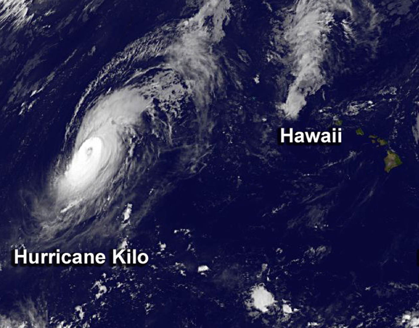
Sep. 01, 2015 – NASA Spots Kilo, Now a Typhoon in the Northwestern Pacific
Hurricane Kilo may have formed in the Central Pacific Ocean, but on September 1 it crossed the International Date Line, so it was classified as a typhoon. NASA’s Aqua satellite spotted a clear eye in the Category 3 typhoon early on September 1.
Different Names, Different Locations
There are three different names for the same kinds of storm all depending on location.
Hurricanes, cyclones, and typhoons are all the same weather phenomenon. In the Atlantic and Northeastern Pacific Ocean, the term “hurricane” is used. The same type of storm in the Northwestern Pacific is called a “typhoon.” In the South Pacific and Indian Ocean, they’re known as “cyclones.”
The International Date Line
The International Date Line lies to the west of Hawaii. It is an imaginary line on the surface of the Earth that stretches from the North to South Pole, and signifies a change in one calendar day. The “line” runs through the middle of the Pacific Ocean, roughly following the 180° line of longitude but zig-zags to pass around some territories and island groups. If traveling over the line, the date west of the line adds 24 hours, while east of the line subtracts 24 hours.
When Aqua passed over Kilo, the Moderate Resolution Imaging Spectroradiometer instrument captured a visible picture of the storm that showed it maintained a clear eye. The eye was surrounded by a thick band of powerful thunderstorms. Large bands of thunderstorms spiraled into the center from the northern and southern quadrants.
Where is Kilo Now?
At 0900 UTC (5 a.m. EDT), Typhoon Kilo had maximum sustained winds near 105 knots (120.8 mph/194.5 kph). It was centered near 22.9 North latitude and 179.6 West longitude. That puts the center about 802 nautical miles east-northeast of Wake Island. Kilo is moving to the north at 7 knots (8 mph/12.9 kph). Currently, Kilo poses no threat to land areas.
Kilo is forecast to move west and intensify to Category 4 storm again by September 4 with maximum sustained winds expected to reach 125 knots (143.8 mph/231.5 kph). Kilo is expected to maintain that intensity for a couple of days.
Rob Gutro
NASA’s Goddard Space Flight Center
Aug. 31, 2015 – NASA Sees Hurricane Kilo Headed for International Date Line
NASA’s Aqua and NOAA’s GOES-West satellite saw Hurricane Kilo moving west in the Central Pacific Ocean as it neared the International Date Line.
The Atmospheric Infrared Sounder or AIRS instrument that flies aboard NASA’s Aqua satellite gathers infrared data that reveals temperatures. When NASA’s Aqua satellite passed over Kilo on August 30, the AIRS data and showed high, cold, strong thunderstorms surrounded the center of Hurricane Kilo, and had cloud top temperatures near -63F/-53C. NASA research has shown that thunderstorms with cloud tops that cold and high in the troposphere have the potential to generate heavy rainfall.
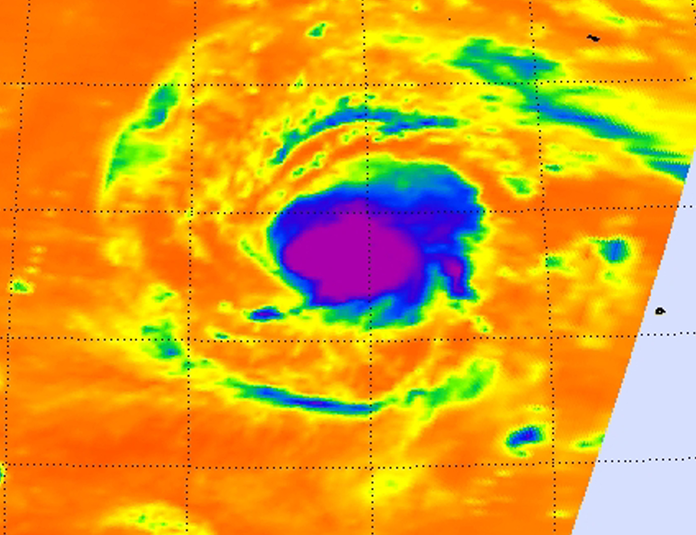
On August 31 at 8:00 a.m. EDT an infrared image from NOAA’s GOES-West satellite clearly showed that Hurricane Kilo maintained its eye.
At 11 a.m. EDT (1500 UTC/5 a.m. HST), the center of Hurricane Kilo was near latitude 21.5 north and longitude 179.3 west. That’s about 480 miles (770 km) south-southwest of Midway Island. Kilo’s maximum sustained winds were near 135 mph (215 kph). That means that Kilo is a category four hurricane on the Saffir-Simpson Hurricane wind scale. The Central Pacific Hurricane Center expects little change in intensity over the next two days.
Kilo is moving toward the north-northwest near 10 mph (17 kph) and is expected to continue in that direction for the next couple of days. CPHC noted that later today, August 31, Kilo may cross the International dateline into the Northwest Pacific Ocean.
F
Rob Gutro
NASA’s Goddard Space Flight Center
Aug. 28, 2015 – NASA Sees Comma Shaped Tropical Storm Kilo
Tropical Storm Kilo looks like a giant comma from space in imagery from NASA’s Aqua satellite. Kilo continues to strengthen and was affecting Johnston Island as a tropical storm warning continued on August 28.
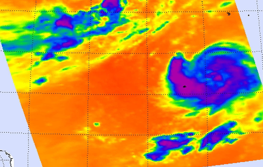
NASA’s Aqua satellite passed over the tropical storm on August 27 at 13:05 UTC (9:05 a.m. EDT. The Atmospheric Infrared Sounder or AIRS instrument aboard Aqua looked at the storm in infrared light, measuring temperatures of cloud tops and surrounding sea surface to help determine where the strongest parts of the storm are, and if the waters surrounding the storm would help it maintain strength.
AIRS showed the strongest thunderstorms stretched high into the troposphere (the lowest layer of the atmosphere) around the center of circulation and in a band of thunderstorms that extended from the center to the south and west, giving the appearance of a giant comma. Cloud-top temperatures in both of those areas were as cold as or colder than -63 Fahrenheit (-53 Celsius), indicating high, powerful thunderstorms with the capability to generate heavy rainfall.
In the image, Johnston Island was near the end of the “tail” of the comma. That means that the island was experiencing tropical storm conditions which are expected to diminish late on August 28. Heavy showers and thunderstorms from Kilo were affecting Johnston Island bringing an additional rainfall amounts of 2 to 4 inches. The Central Pacific Hurricane Center noted that large surf will continue on the island on August 28, especially along northwest and north facing shores and reefs.
At 11 a.m. EDT (1500 UTC) the center of Tropical Storm Kilo was located near latitude 17.2 north and longitude 170.6 west. Maximum sustained winds were near 70 mph (110 kph) and the CPHC expects Kilo to become a hurricane and slowly intensify during the next couple of days.
Kilo was moving toward the west near 8 mph and is expected to gradually turn west-northwest on August 29. The estimated minimum central pressure is 990 millibars. For updates, visit the CPHC website at: http://www.prh.noaa.gov/cphc.
Rob Gutro
NASA’s Goddard Space Flight Center
Aug. 27, 2015 – NASA Sees Tropical Storm Kilo Wrapped Halfway Around Itself
When NASA’s Aqua satellite passed over Tropical Storm Kilo early on August 27, infrared imagery showed that bands of thunderstorms wrapped more than halfway around the system.
On August 27, a tropical storm warning was in effect for Johnston Island as Kilo moved closer. Bands of rain and thunderstorms have already been affecting the islands and are expected to continue as the storm moves closer. NOAA’s Central Pacific Hurricane Center expects Kilo to bring between 5 to 10 inches of rainfall, with isolated maximum totals near 15 inches.
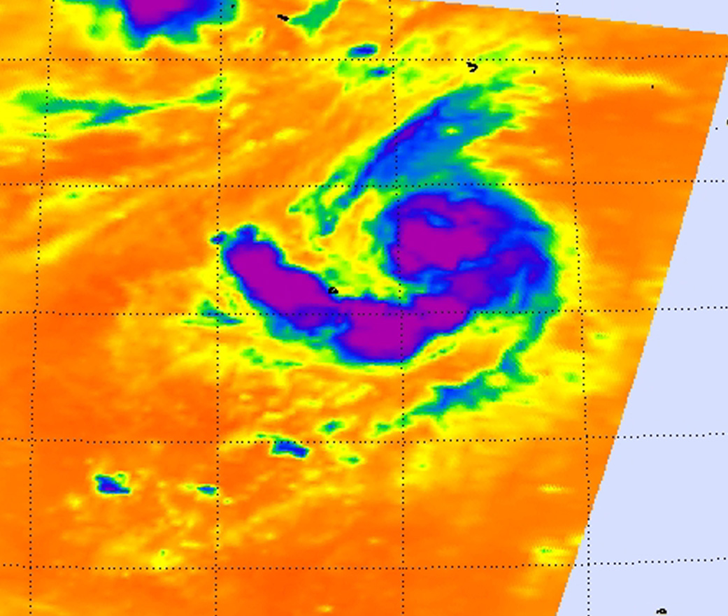
A false-colored infrared image of Tropical Storm Kilo from August 27 at 00:53 UTC (8:53 p.m. EDT, Aug. 26) showed high, cold, strong thunderstorms with cloud top temperatures in excess of -63F/-53C wrapping halfway around the eastern side of the storm from north to south. The data was made into an image at NASA’s Jet Propulsion Laboratory in Pasadena California, using data from the Atmospheric Infrared Sounder or AIRS instrument that flies aboard NASA’s Aqua satellite.
AIRS data also showed that the sea surface temperatures around Kilo are near 29 Celsius (84.2 Fahrenheit), warm enough to promote strengthening. Tropical cyclones need sea surface temperatures of at least 26.6C/80F to maintain strength. Warmer sea surface temperatures will assist in strengthening.
At 9 a.m. EDT (5 a.m. HST/1500 UTC) on August 27, 2015 the center of tropical storm kilo was located near latitude 17.8 north and longitude 168.1 west.
Kilo is crawling toward the southwest near 1 mph (2 kph) and is expected to turn west and speed up slowly over August 28 and 29. Maximum sustained winds were near 65 mph (100 kph) and slow strengthening is expected through August 29. The estimated minimum central pressure is 994 millibars.
CPHC indicated that tropical storm conditions are expected on Johnston Island on August 27, as well as increasing large surf especially along north and northeast facing shores and reefs as Kilo approaches. For updates, visit: http://www.prh.noaa.gov/hnl/cphc/.
Kilo is expected to reach hurricane strength after passing Johnston Island and then head north-northwest.
Rob Gutro
NASA’s Goddard Space Flight Center
Aug. 25, 2015 – GPM Sees Energetic Tropical Depression Kilo
Rainfall associated with Tropical Depression Kilo recently dumped heavy rain in some areas of the state of Hawaii. The Global Precipitation Measurement or GPM mission core satellite analyzed Kilo’s rainfall as it passed overhead early on August 25.
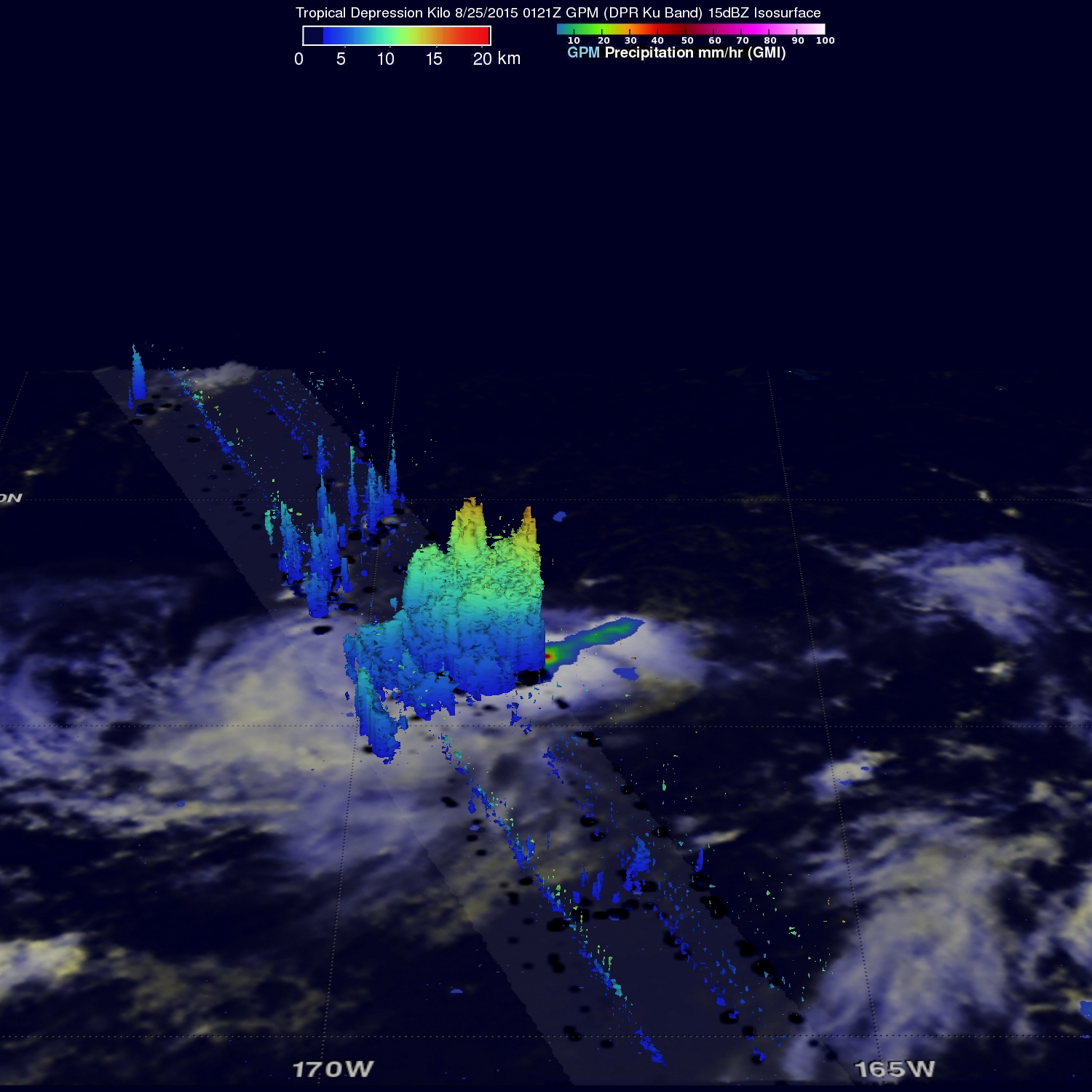
Tropical depression Kilo changed course to move away from the Hawaiian Islands so it is no longer a threat, but has recently been more energetic. The GPM core observatory satellite flew over on August 25, 2015 at 0121 UTC as Kilo approached Johnson Atoll and found that rainfall intensity had recently increased and the tropical depression’s storm tops were very tall.
GPM’s Dual-Frequency Precipitation Radar (DPR) discovered that rain was falling at a rate of almost 65 mm (2.6 inches) per hour and storm tops were measured at altitudes of over 15.4 km (9.5 miles). Images were created at NASA’s Goddard Space Flight Center in Greenbelt, Maryland. GPM is a satellite managed by both NASA and the Japan Aerospace Exploration Agency.
On Tuesday, August 25, 2015 at 5 a.m. EDT (11 p.m. HST/Aug. 24) the center of Tropical Depression Kilo was located near latitude 18.4 north…longitude 167.3 west. That means that the center was about 185 miles (300 km) northeast of Johnston Island and about 640 miles (1,035 km) west-southwest of Honolulu, Hawaii. Maximum sustained winds are near 30 mph (45 kph) and the Central Pacific Hurricane Center (CPHC) predicts some slow intensification from late from Tuesday through Wednesday night.
The depression was moving toward the north near 8 mph (13 kph) and is expected to turn toward the northwest then move toward the west by August 26. The estimated minimum central pressure is 1006 millibars.
The CPHC predicts that Kilo will strengthen again into a tropical storm as it moves harmlessly westward over the open waters of the central Pacific Ocean.
Hal Pierce
SSAI/NASA’s Goddard Space Flight Center
Aug. 24, 2015 – GPM Sees Rainfall in Tropical Depression Kilo Nearing Johnston Island
Credits: SSAI/NASA, Hal Pierce
The Global Precipitation Measurement or GPM mission core satellite gathered rainfall data on Tropical Depression Kilo as it heads toward Johnston Island in the Central Pacific Ocean. On August 24, a Tropical Storm Warning was posted for Johnston Island.
Kilo formed as depression and strengthened into a tropical storm to southeast of the Hawaiian Islands on August 20, 2015. By 5 a.m. EDT on Sunday, August 23, Kilo weakened to a tropical depression. Today, August 24, the tropical depression nearing Johnston Island.
The National Hurricane Center noted that Johnston Island will experience tropical storm conditions today and tomorrow, August 25. Large surf is expected especially along east and southeast facing reefs and shorelines through Wednesday, August 25, and Kilo is expected to drop between 4 to 8 inches of rainfall along and near its track.
That rainfall was seen by the GPM core observatory satellite on August 23, 2015 at 0131 UTC (Aug. 22 at 11:31 p.m. EDT). GPM’s Microwave Imager (GMI) and Dual-Frequency Precipitation Radar (DPR) discovered that rain was falling at a rate of over 121 mm (4.8 inches) in powerful storms on the northern side of Kilo. Those same storms are shown in a 3-D simulated view reaching heights of over 16.6 km (10.3 miles). The GPM satellite is managed by NASA and the Japan Aerospace Exploration Agency.
On August 24 at 1200 UTC (8 a.m. EDT), the center of Tropical Depression Kilo was located near latitude 14.8 north and longitude 166.7 west. That’s about 160 miles (255 km) east of Johnston Island the Depression is moving toward the west-northwest near 7 mph (11 kph). The estimated minimum central pressure is 1006 millibars. Maximum sustained winds are near 35 mph (55 kph). For updated forecasts, visit NOAA’s Central Pacific Hurricane Center website: http://www.prh.noaa.gov/cphc.
Kilo is expected to strengthen to a tropical storm later today and into a hurricane by Tuesday, August 25 as it turns northeast toward the island of Nihoa.
Hal Pierce/Rob Gutro
NASA’s Goddard Space Flight Center
Aug. 21, 2015 – NASA Sees Development of Tropical Storm Kilo
A new tropical storm formed in the Central Pacific Ocean today, August 21, named Kilo. NASA’s Aqua satellite passed the storm when it was a developing low pressure area the day before.
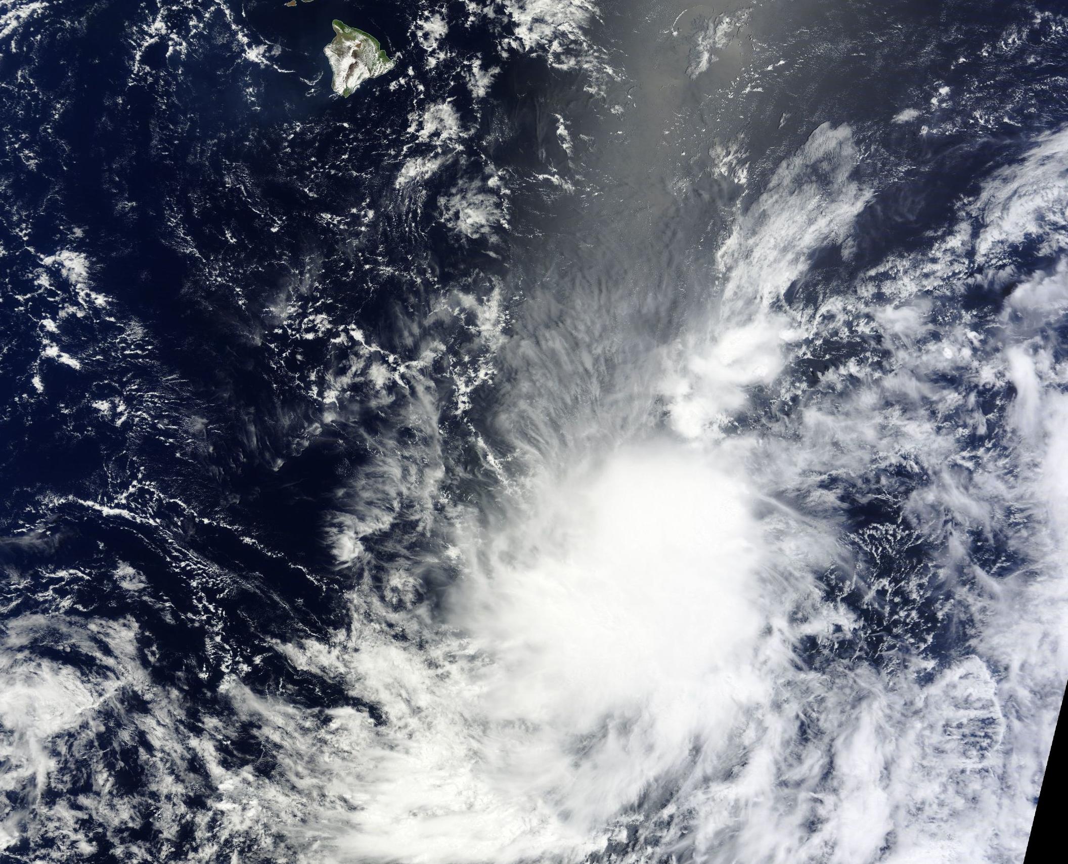
NASA’s Aqua satellite flew over the tropical low pressure area on August 20 was it was organizing into Tropical Depression 3C. NOAA’s Central Pacific Hurricane Center (CPHC) noted that the low became a depression at 5 p.m. EDT on August 20. The Moderate Resolution Imaging Spectroradiometer (MODIS) instrument aboard Aqua captured a visible image of the developing storm that showed a good circulation (rounded) and thunderstorms around the low-level center of circulation.
By 11 a.m. EDT on August 21, Tropical Depression 3C strengthened into a tropical storm and was renamed Kilo. At that time, Kilo’s center was located near latitude 12.7 north…longitude 151.7 west. That puts the center of Kilo about 535 miles (860 km) south-southeast of Hilo, Hawaii and 720 miles (1,160 km) southeast of Honolulu. The estimated minimum central pressure is 1004 millibars.
Kilo was moving toward the west-northwest near 16 mph (26 kph) and had maximum sustained winds near 40 mph (65 kph). The CPHC expects Kilo to gradually strengthen over the next couple of days.
For updates on the storm visit NOAA’s CPHC website: http://www.prh.noaa.gov/cphc