


![Request for Information – Potential [Placeholder for Prize]](https://assets.science.nasa.gov/dynamicimage/assets/science/psd/solar/2023/09/s/solarsystem_0.jpg?w=1024)


Satellite Shows Post-tropical Cyclone Selma Dissipate
NOAA’s GOES East satellite provided an image of Post-Tropical Cyclone Selma as it dissipated near the border of El Salvador and Honduras.
The National Hurricane Center final advisory on Selma was issued on Oct. 28 at 4 p.m. CDT (2100 UTC). At that time the National Hurricane Center said the center of Post-Tropical Cyclone Selma was located near 14.3 degrees north latitude and 88.8 degrees west longitude. At the time, maximum sustained winds had decreased to near 30 mph (45 kph) with higher gusts. The estimated minimum central pressure was 1007 millibars.
At that time NHC Forecaster Roberts noted in the NHC discussion “Visible satellite imagery, radar data, and surface observations indicate that Selma has degenerated to a poorly-defined remnant low near the border of El Salvador and Honduras, and this will be the last advisory. Weakening will continue, and the cyclone is expected to dissipate over the Sierra Madre Mountains tonight (Oct. 28).”
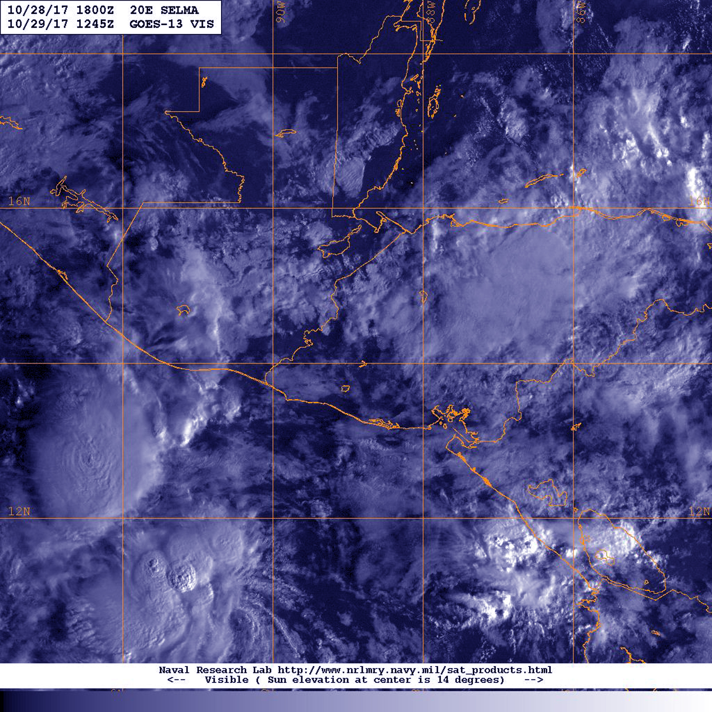
Selma dissipated near the border between El Salvador and Honduras.
NOAA’s GOES East satellite provided a visible image of the remnant clouds over western Honduras on Oct. 29 at 8:45 a.m. EDT (1245 UTC).
By Rob Gutro
NASA’s Goddard Space Flight Center
Oct. 27, 2017 – NASA Finds New Tropical Storm Selma Has Heavy Rain-making Potential
Tropical Storm Selma formed in the Eastern Pacific Ocean off the coast of El Salvador and NASA infrared satellite imagery revealed the storm has very cold cloud top temperatures indicating the potential for heavy rain.
A Tropical Storm Warning is in effect for the entire coast of El Salvador and a Tropical Storm Watch is in effect for the Pacific coast of Guatemala.
The National Hurricane Center noted that Selma is a sheared tropical cyclone. That means vertical wind shear is pushing clouds associated with the storm away from the center of circulation. Early morning visible satellite images and recent microwave imagery showed that the center is located near the northeastern edge of a small, but persistent cluster of deep convection.
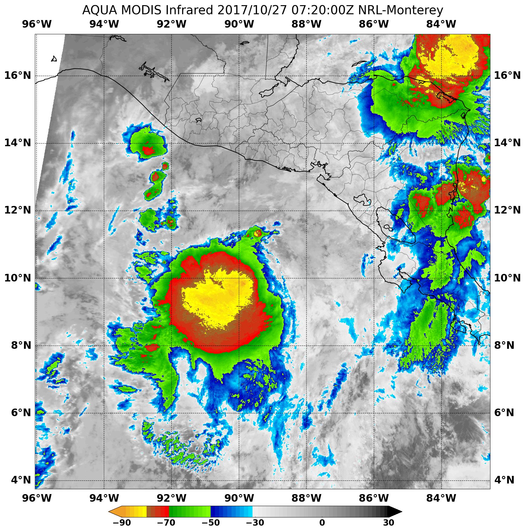
When NASA’s Aqua satellite passed over Selma on Oct. 27 at 3:20 a.m. EDT (0720 UTC), the MODIS instrument aboard showed strongest storms were northeast of center. Those strong storms had cloud top temperatures as cold as minus 80 degrees Fahrenheit (minus 62.2 degrees Celsius), indicating strong thunderstorms with potential for heavy rainfall.
At 10 a.m. CDT (1500 UTC), the center of Tropical Storm Selma was located near 11.1 degrees north latitude and 89.5 degrees west longitude. That’s about 180 miles (290 km) south of San Salvador, El Salvador. Selma is moving toward the northwest near 5 mph (7 kph) and the cyclone is expected to turn toward the north by early Saturday. On the forecast track, the center of Selma will approach the coast of El Salvador or Guatemala on Saturday.
Maximum sustained winds are near 40 mph (65 kph) with higher gusts. Slight strengthening is forecast before Selma reaches the coast of Central America. The estimated minimum central pressure is 1005 millibars.
The heavy rainfall potential is included in the National Hurricane Center (NHC) forecast. NHC said that Selma is expected to produce total rain accumulations of 3 to 6 inches over El Salvador, southern Guatemala, southern Honduras and far western Nicaragua over the next couple of days. Isolated maximum amounts of 10 inches are possible in El Salvador and southern Guatemala. This rainfall could cause life-threatening flash floods and mudslides.
NHC’s forecast takes Selma north to a landfall in western El Salvador on Saturday night, October 28.
For updated forecasts on Selma, visit: www.nhc.noaa.gov
By Rob Gutro
NASA’s Goddard Space Flight Center