![Request for Information – Potential [Placeholder for Prize]](https://assets.science.nasa.gov/dynamicimage/assets/science/psd/solar/2023/09/s/solarsystem_0.jpg?w=1024)


NASA Spots a Diminished, but Drenching Ex-Tropical Cyclone Don
Tropical Storm Don didn’t live long before it weakened to a remnant low pressure area in the North Atlantic Ocean. Before it weakened NASA-NOAA’s Suomi NPP satellite captured a visible image of the storm on its approach to the Windward Islands. The GPM satellite analyzed the storm’s rainfall as it developed and moderate to heavy rainfall is expected to accompany the remnants in the Windward Islands on July 19.
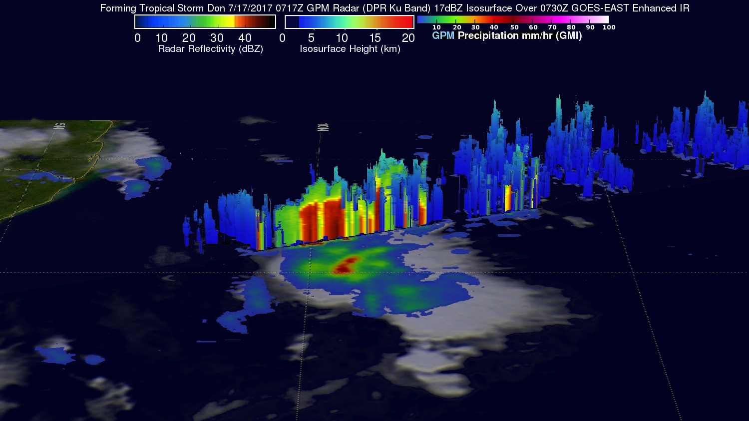
When the Global Precipitation Measurement mission or GPM core satellite passed overhead Tropical Storm Don on July 17, the instruments aboard examined the storm’s rainfall rates.
The GPM core observatory satellite flew above Don as it was forming at 3:17 a.m. EDT (0717 UTC). GPM’s Microwave Imager and Dual-Frequency Precipitation Radar instruments collected data that were used to evaluate precipitation within the forming tropical cyclone. GPM’s Radar data swath covered an area to the west of the greatest amount of rainfall. GPM’s radar found rain falling at a rate of over 4.4 inches (112 mm) in the area of heaviest rainfall. GPM’s Radar data revealed the heights of some storm tops around the low-level center near heights of up to 7.4 miles (12 km).
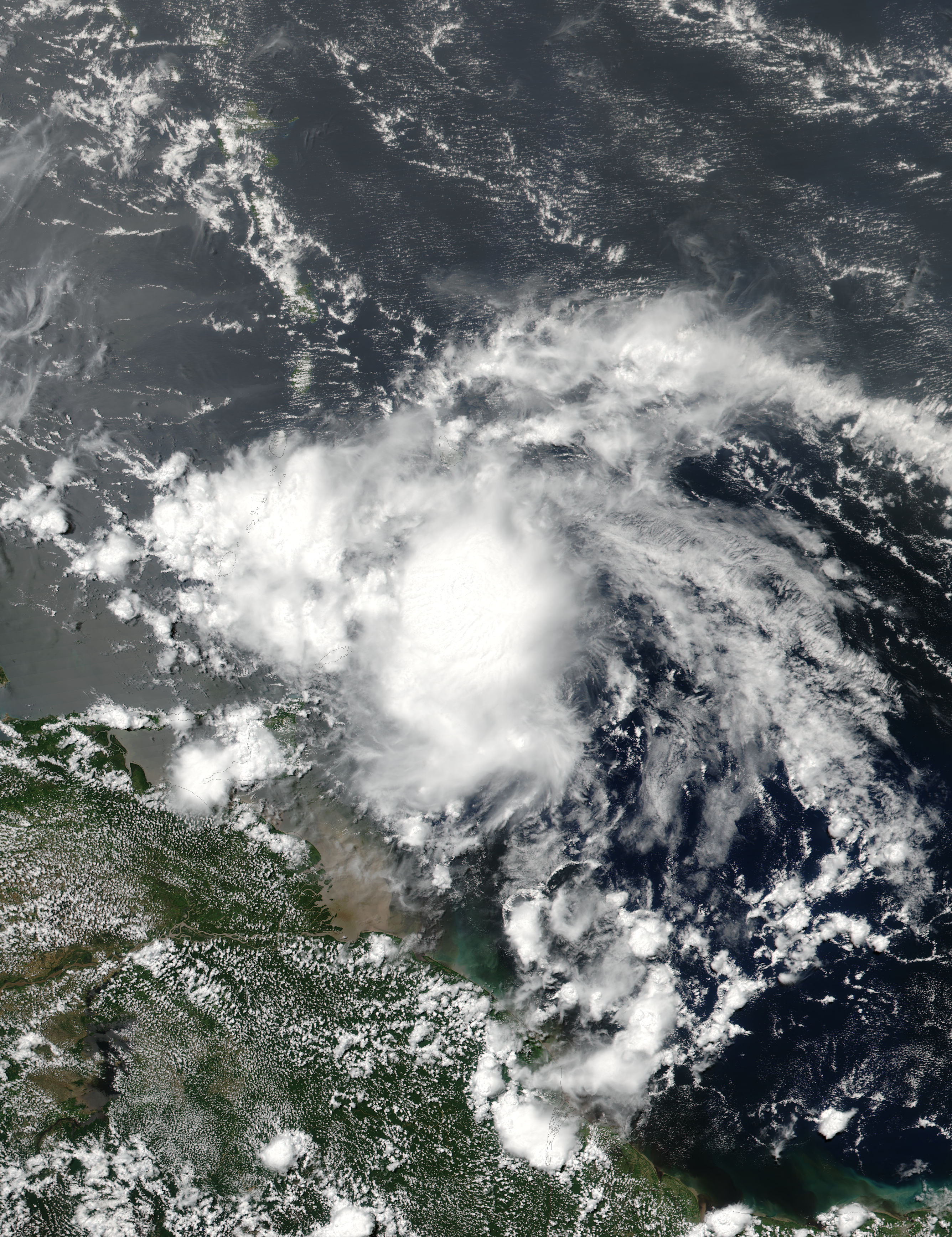
When Don was still maintaining tropical storm status NASA-NOAA’s Suomi NPP satellite captured this visible light image of the center of the storm approaching the Windward Islands on July 18 at 1:16 p.m. EDT (1716 UTC). The image showed that a band of thunderstorms west of center were affecting the islands of Saint Vincent and the Grenadines, Grenada, Trinidad and Tobago.
It didn’t take long for wind shear to affect Don and weaken the system into a remnant low pressure area. By 6:33 a.m. EDT on July 19, the National Hurricane Center or NHC in Miami, Florida said that Don had become a remnant low.
The NHC forecast called for the remnants of Don to move across the Windward Islands. At 5 a.m. EDT (0900 IUTC) the remnants of Don were centered near the island of La Blanquilla. Don’s remnants were moving westward at 22 knots and the estimated minimum central pressure is 1012 millibars.
As GPM observed on July 17, the system contained heavy rainfall. On July 19, the NHC said that the remnants of Don is expected to produce total rain accumulations of 3 to 6 inches. There remains a potential for life-threatening flash floods and mudslides, along the coast of Venezuela.
By Rob Gutro and Hal Pierce
NASA’s Goddard Space Flight Center, Greenbelt, Md.
July 18, 2017 – NASA Looks at Compact Tropical Storm Don in Infrared Light
NASA’s Aqua satellite passed over newly formed Tropical Storm Don gathering temperature data from the compact storm’s clouds.
At 5 p.m. EDT on July 17 Don formed rapidly from a low pressure area into a tropical storm about 485 miles (780 km) east-southeast of Barbados.
On July 18, a tropical storm warning was in effect for Grenada and St. Vincent and the Grenadines. A tropical storm watch was in effect for Barbados, St. Lucia and Bonaire.
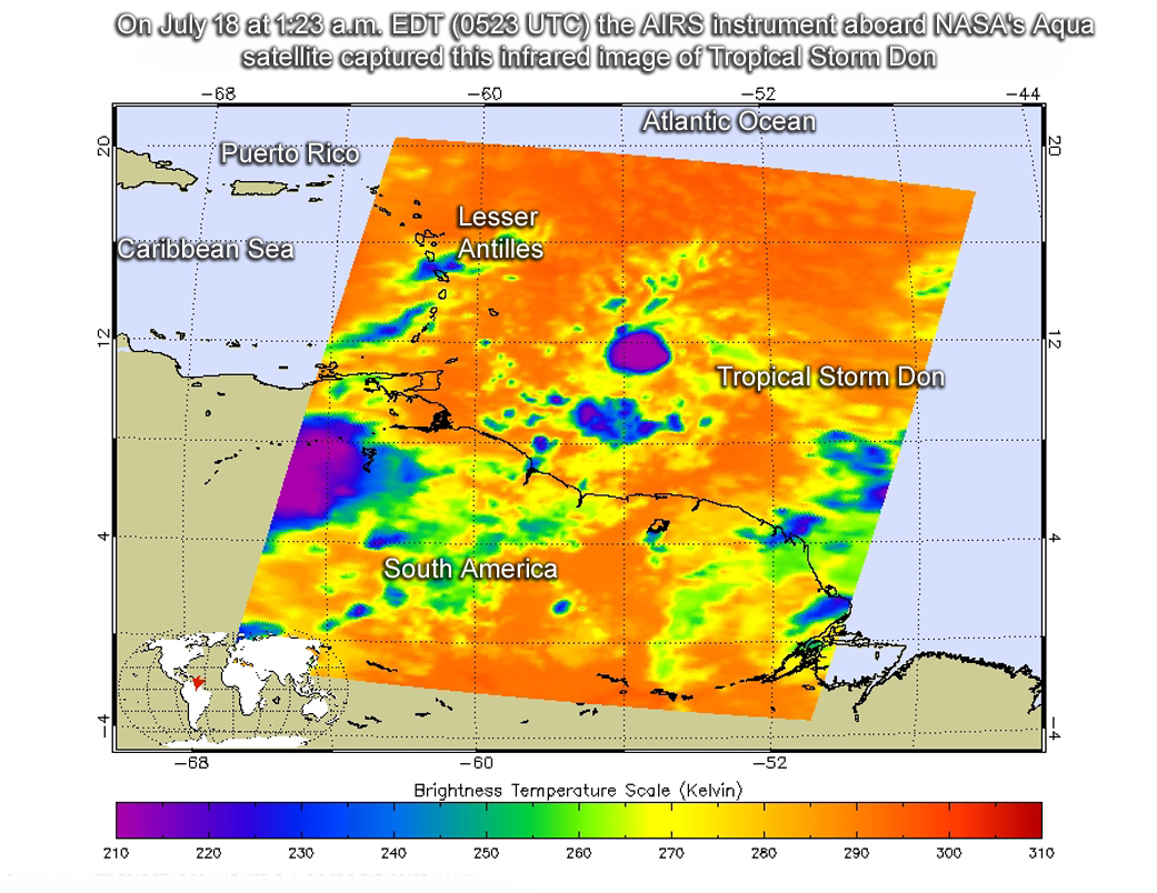
The Atmospheric Infrared Sounder, or AIRS, instrument aboard NASA’s Aqua satellite looked at Tropical Storm Don in infrared light. Infrared light provides scientists with temperature data and that’s important when trying to understand how strong storms can be. The higher the cloud tops, the colder and the stronger they are. So infrared light as that gathered by the AIRS instrument can identify the strongest storms within a tropical cyclone.
AIRS infrared data gathered on July 18 at 1:23 a.m. EDT (0523 UTC) showed the storm to be compact with a small area of strong thunderstorms around the center. Some cloud top temperatures around the low-level center were as cold as minus 63 degrees Fahrenheit (minus 53 degrees Celsius). The National Hurricane Center noted that there have also been periodic bursts of deep convection very near the center, accompanied by significant clusters of lightning activity, which is indicative of strong updrafts in or near the radius of maximum winds.
By 8 a.m. EDT (1200 UTC) the center of Tropical Storm Don was located near 11.4 degrees north latitude and 57.0 degrees west longitude. That’s about 210 miles (335 km) southeast of Barbados. Don was moving toward the west near 18 mph (30 kph). The National Hurricane Center (NHC) expects this general motion to continue with an increase in forward speed through Wednesday evening, July 19. The estimated minimum central pressure is 1,010 millibars.
Maximum sustained winds are near 50 mph (85 kph) with higher gusts. Little change in strength is expected before the system reaches the Windward Islands. Weakening is expected on Wednesday while Don moves across the southeastern Caribbean Sea.
NHC said that on the forecast track, the center of Don will move across the Windward Islands tonight, and then move westward across the southeastern Caribbean Sea on Wednesday.
For updated forecasts, visit: www.nhc.noaa.gov
By Rob Gutro
NASA’s Goddard Space Flight Center, Greenbelt, Md.