


![Request for Information – Potential [Placeholder for Prize]](https://assets.science.nasa.gov/dynamicimage/assets/science/psd/solar/2023/09/s/solarsystem_0.jpg?w=1024)


The ability to provide a “volcano forecast” could help reduce the significant health, safety, and even economic impacts of eruptions; they regularly disrupt aviation and the global supply chain we depend on. Last fall, circling the summit of an active volcano, a small aircraft moved us toward a future where remote but hazardous volcanoes are consistently monitored for signs an eruption could be brewing.
This unmanned aircraft system, or UAS, commonly known as a drone, was specially designed for scientific uses in challenging environments – and then upgraded to become an airborne volcano-observing platform. With flights to Makushin Volcano in Alaska’s Aleutian Islands in September 2021, a group of federal scientists and industry engineers demonstrated the UAS could successfully fly without its pilots’ eyes on the aircraft. And that opens new possibilities for monitoring volcanoes and other hazards worldwide.
Out-of-Sight Flights, Years in the Making

Sending researchers on foot or piloted aircraft to survey volcanoes up close can be dangerous and costly. It’s also just not realistic to do for a large number of volcanoes on a regular basis. But a sophisticated UAS could do the job, if it could fly beyond the visual line of sight of its operators. The capability, known by the acronym BVLOS, marks a kind of threshold that, once passed, will make many more applications possible.
At NASA, using UASs for up-close monitoring of volcanoes was first demonstrated by researchers from the agency’s Ames Research Center in California’s Silicon Valley. In 2013, they collected science data by flying small, fixed-wing drones over Turrialba Volcano in Costa Rica.
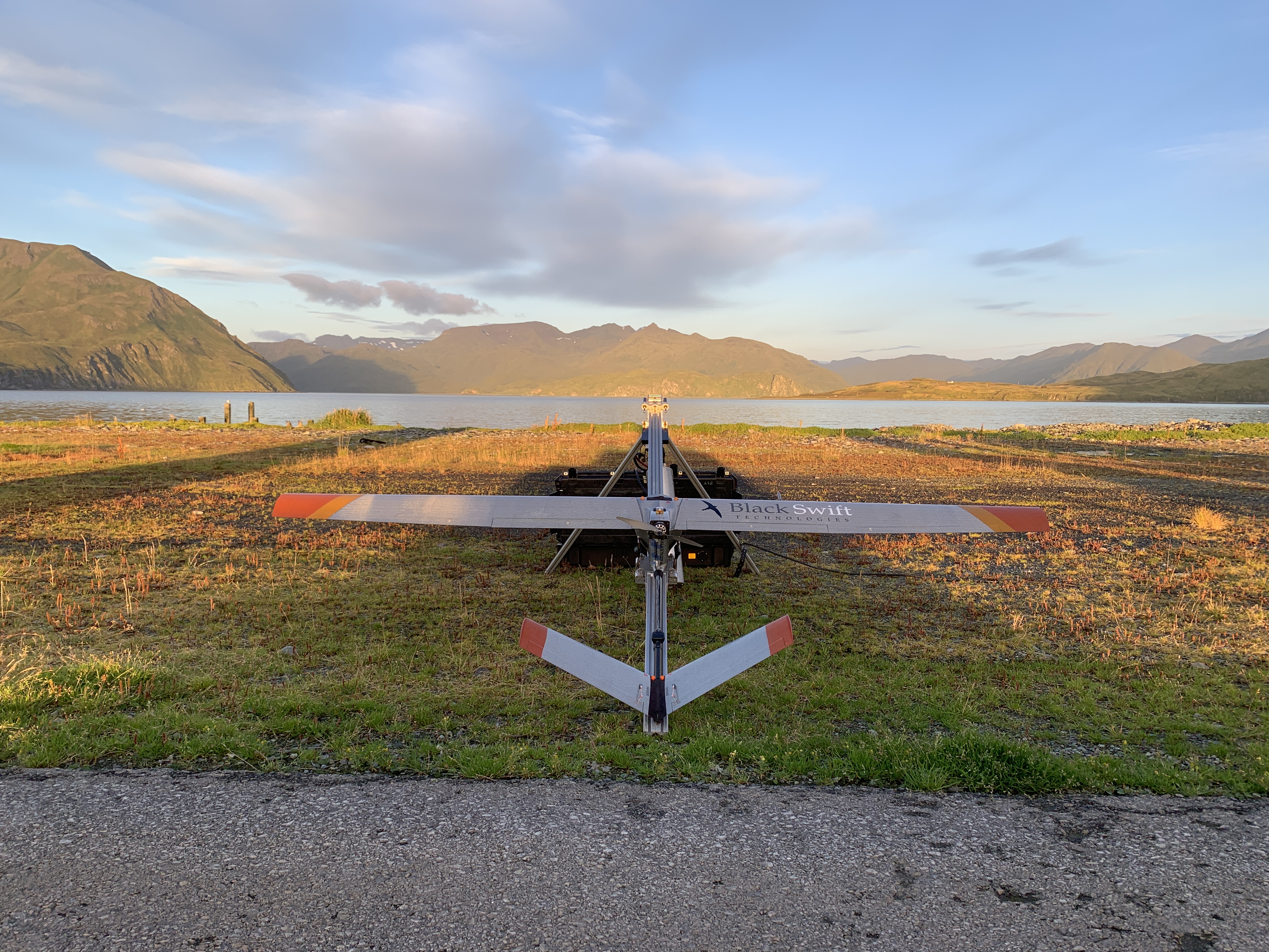
Later, a long-term collaboration between NASA and Black Swift Technologies of Boulder, Colorado, resulted in the S2 UAS, which made the recent groundbreaking flights in Alaska.
“We needed it to be really rugged, to withstand flying in the turbulent conditions and corrosive gases around volcanoes,” said Florian Schwandner, director of the Earth Sciences division at Ames and an early member of the project. “We also developed a gas-sensing payload the UAS could carry to look for signs of volcanic unrest.”
When the U.S. Geological Survey joined the partnership a few years in, they brought an even more capable payload to detect additional gases and collect visual and thermal images.
The development path that led to the S2’s flight demonstration was supported in part by NASA’s Small Business Innovation Research and Small Business Technology Transfer program, whose management office is located at Ames. The program funds small businesses and research institutions for the research, development, and demonstration of innovative technologies with significant potential for successful commercialization. For all drones, scientific and otherwise, achieving safe BVLOS flight is the next big step toward widespread commercial use.
To the Summit and Back
To demonstrate the S2 could fly this way – with no eyes on the aircraft, only on monitors displaying its flight path – one major requirement was a plan for integrating the UAS safely into the airspace. The Flight Operations division at Ames worked with the Federal Aviation Administration and Black Swift to develop the operations necessary to fly safely out of sight.
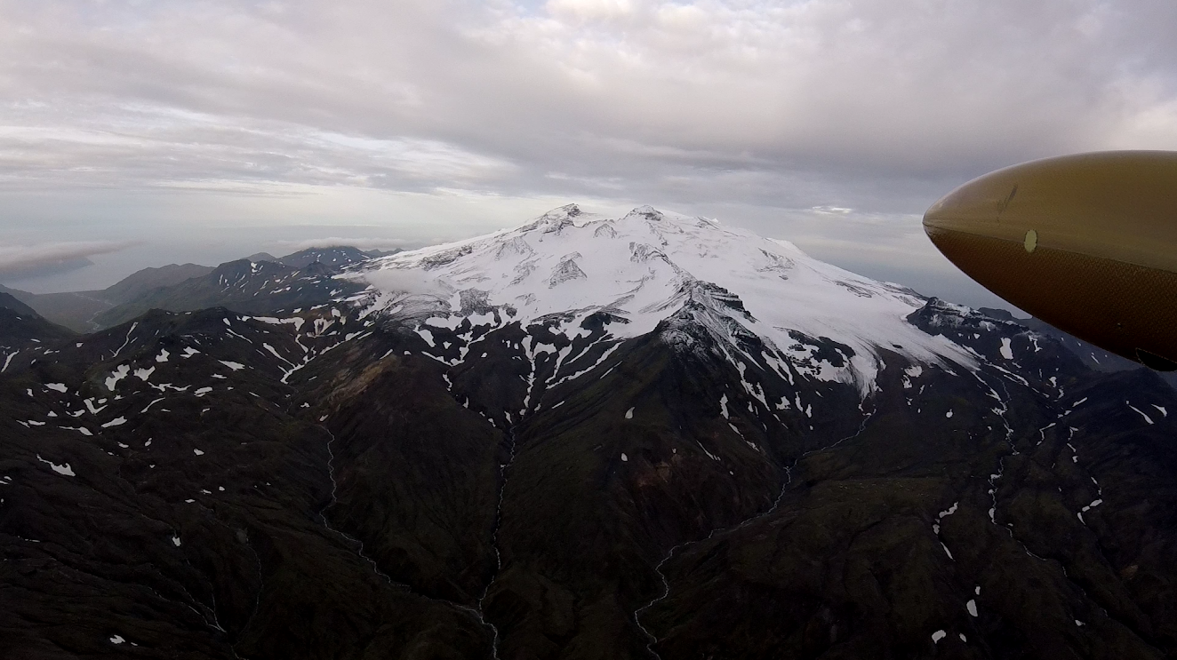
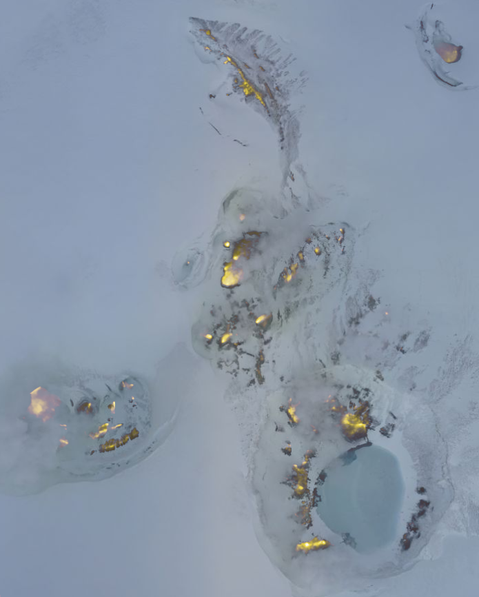
During the deployment, the team flew four BVLOS missions to Makushin Volcano, 15 miles away. The S2 relied on its autonomous systems and a programmed flight plan to reach the summit, where the aircraft captured high-resolution visible-light and thermal images. The team’s scientists confirmed they could use these to detect changes in physical features that indicate volcanic activity changing underground. The flights also demonstrated the capacity of sensors aboard the aircraft to detect gases that may signal changes in activity brewing in the volcano’s depths.
“Our goal is to continue to push the capabilities of UASs to provide valuable insight into natural phenomena,” said Jack Elston, CEO of Black Swift Technologies. “This deployment demonstrated some state-of-the-art automation technologies we think will help greatly simplify what are now very difficult UAS operations. One of the most exciting results was to see our custom autopilot system determine when conditions had become too dangerous and turn back.”
A Future of Routine Flights
The proven ability to fly safely beyond range of a pilot’s sight with this scientific platform paves the way for more routine operations.
“Working with NASA and Black Swift, our scientists believe we can use UASs to help authorities warn communities about the onset of dangerous volcanic eruptions, and many other hazards that now take us by surprise,” said Jonathan Stock, director of the USGS National Innovation Center, which helped fund and coordinate the September 2021 flights. “With this tool, we could routinely monitor even remote volcanoes for activity and respond to eruption events – a gamechanger for the safety of both our scientists and the communities around these geologic hazards.”
This partnership between government and small business could make BVLOS drone flights possible for tracking and responding to a diverse suite of hazards around the world, including droughts, floods, wildfires, and many more.
This work is the product of a long-term partnership between NASA, Black Swift Technologies LLC, and USGS. Funding for the Makushin Volcano project was provided by the USGS National Land Imaging Program and the USGS National Innovation Center, working with NASA’s SBIR/STTR program to leverage NASA’s original investment in the aircraft prototype. USGS also funded the NASA Ames Flight Operations division through an interagency agreement to provide airworthiness reviews and airspace integration coordination with the FAA.
Banner image: The S2 UAS ready for deployment on its pneumatic launcher at Dutch Harbor airport in Alaska. Credits: Aleutian Aerial/Andy Dietrick
For news media:
Members of the news media interested in covering this topic should reach out to the NASA Ames newsroom.
Author: Abby Tabor, NASA’s Ames Research Center