


Whether developing new technologies for landing on other planets, improving air travel here at home, or more realistically simulating global weather and climate, supercomputing is key to the success of NASA missions. These advances and more were on display in the agency’s hybrid exhibit during SC22, the International Conference for High Performance Computing, Networking, Storage and Analysis:
1. Designing safe, efficient air taxis.
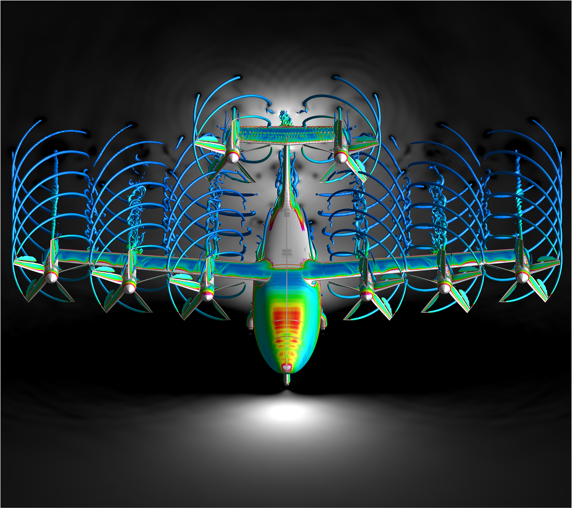
Using NASA’s powerful supercomputers, researchers are simulating the aerodynamic performance of several promising air taxi vehicle configurations that will someday carry passengers and cargo in urban and suburban areas. The highly complex simulations will be used to help design and develop these future air taxis—also called Advanced Air Mobility (AAM) vehicles—that will be safe, quiet, and efficient.
NASA plays an important role in the development of AAM by identifying key research areas and conceptualizing the design of AAM vehicles. Recent simulations focus on the performance of tiltwing and quiet single-main rotor AAM concept vehicles. Simulations were carried out on the supercomputers, such as Aitken, at the NASA Advanced Supercomputing (NAS) facility at the agency’s Ames Research Center in California’s Silicon Valley, which allowed such complex simulations to be solved in just a few days. Understanding the complex flow structures in these rotary-wing aircraft is key to reaching AAM performance and noise-level goals.
2. Keeping planetary rovers safe during risky landings.
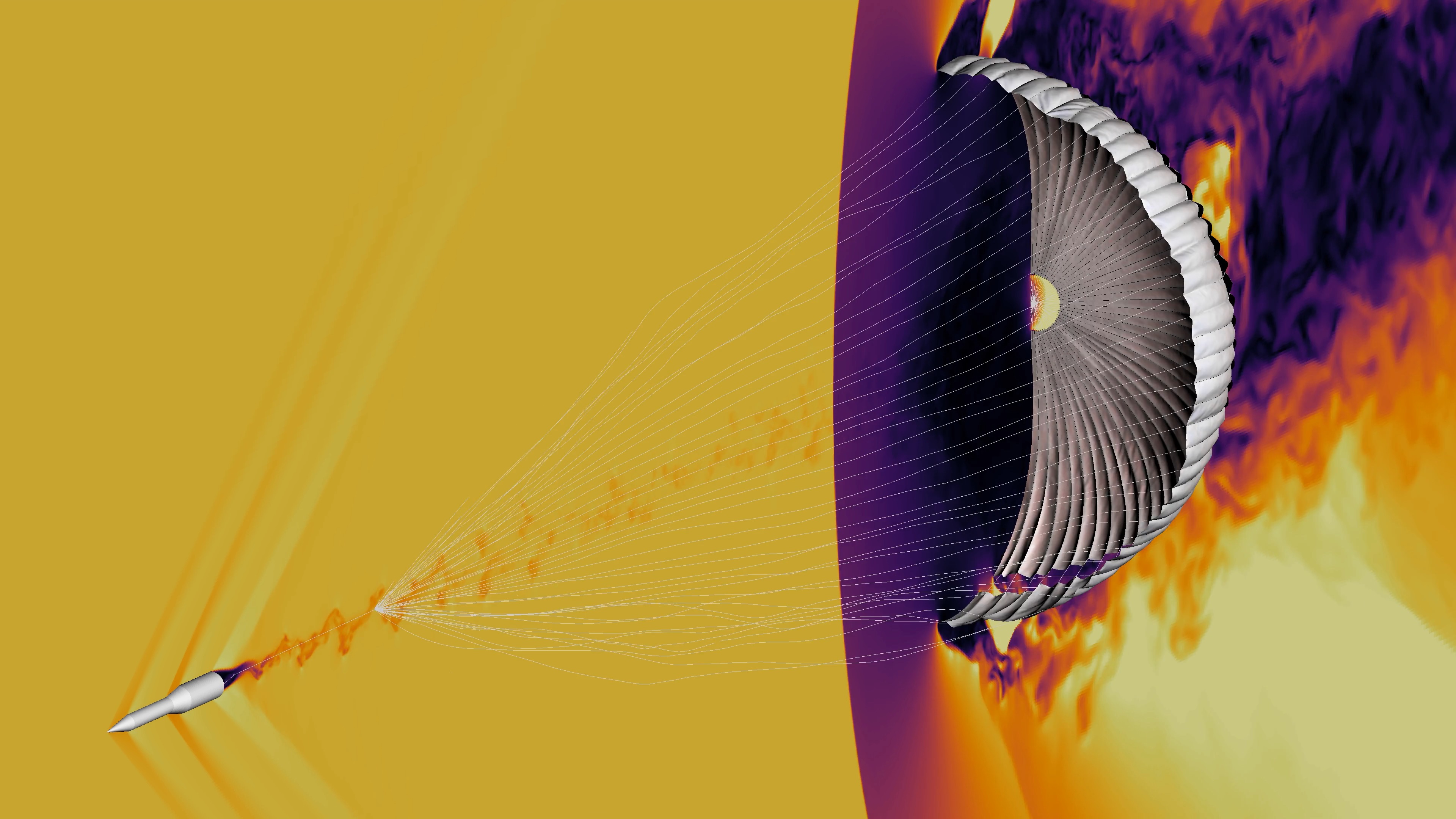
The entry, descent, and landing (EDL) sequence for NASA’s Mars landers has infamously been called the “seven minutes of terror,” because hundreds of critical events need to happen successfully—without intervention from Earth, due to the signal lag between the two planets. Roughly four minutes into descent, the spacecraft deploys a parachute that must inflate as evenly as possible, despite a wake of turbulent air, and without any rips or tears to the tightly woven fabric. This is one of the riskiest aspects of EDL and is notoriously challenging to predict.
Using the agency’s Aitken supercomputer, engineers at Ames are developing the capability to reduce risk and cost by simulating and analyzing many scenarios of supersonic parachute inflation, which would be too costly to study using flight tests. Another advantage to simulations is that fine-scale details can be extracted —that information can help engineers develop next-generation EDL systems able to handle the heavier payloads of future robotic Mars missions, like Mars Sample Return.
3. Modeling spacecraft heat shield materials at the microscale.
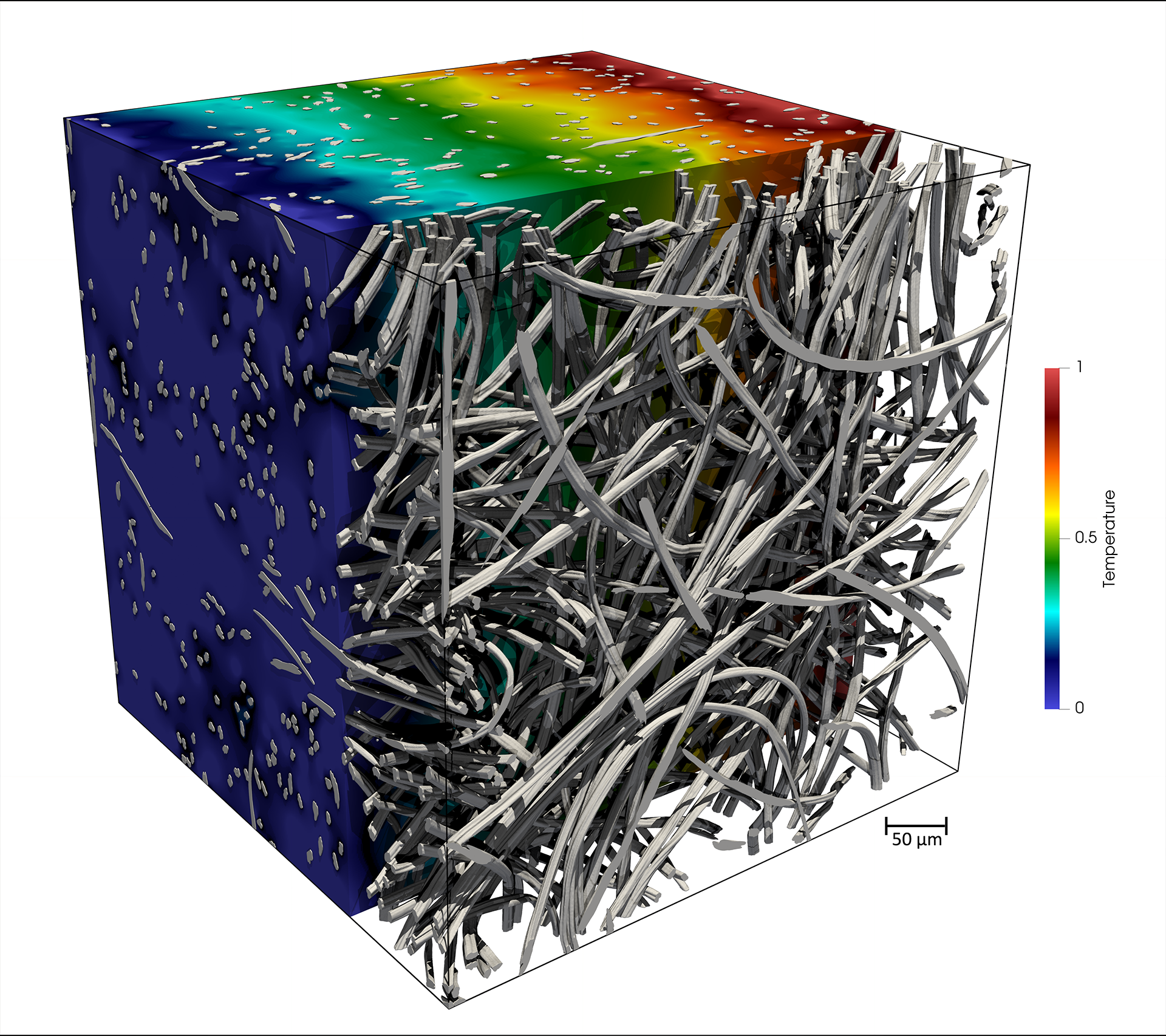
NASA’s Porous Microstructure Analysis (PuMA) software uses X-ray microtomography to generate high-resolution 3D images of a material’s inner structure. PuMA, developed at Ames, provides unprecedented insights into materials used in heat shields for spacecraft, supersonic parachutes, and for meteorite analysis. NASA researchers use PuMA to develop new thermal protection system (TPS) materials for future space missions, and NASA’s high-performance supercomputers provide material scientists with the ability to run full-scale modeling on a material’s microstructure. This helps ensure the safety of future spacecraft, especially during the dangerous descent phase.
While this open-source software was originally created as a tool to predict material properties for TPS for spacecraft, PuMA has expanded to provide scientists the ability to combine material generation – from simple shapes to complex fibrous woven geometries – with studies of the material’s performance, such as its conductivity, elasticity, permeability, and even the way it oxidizes.
4. Predicting weather and climate to keep humans safe.
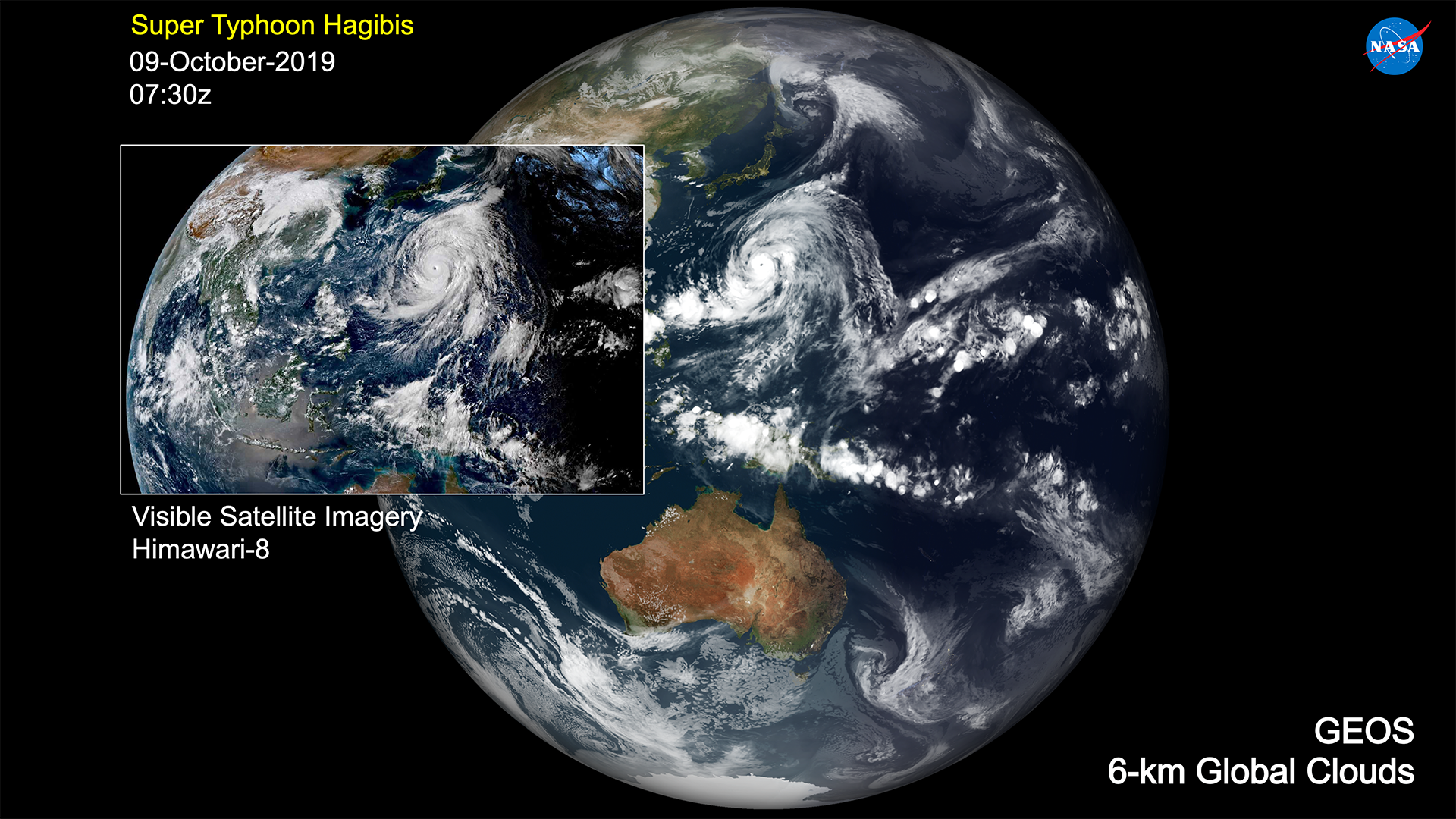
NASA is pushing the edge of modeling capability with the creation of a 1.5 kilometer (about 1 mile) resolution, global digital twin of Earth using supercomputers. The Global Modeling and Assimilation Office at NASA’s Goddard Space Flight Center in Greenbelt, Maryland, is using historical observational data to simulate the Earth system’s weather and climate. The NASA Global Earth Observing System (GEOS) model and assimilation system is the agency’s flagship system for enhancing the use of NASA’s extensive Earth observations.
With the vast expansion of machine learning capabilities and improved programming paradigms for super-fast graphics processing units, GEOS is now poised to provide an experimental framework within NASA for weather and climate studies. The GEOS model will have a range of capabilities including coupled ocean-atmosphere Earth system modeling, advanced studies of carbon emission, and transport at ultra-high resolutions.
5. Exploring the past, present, and future of planets inside and outside our solar system.
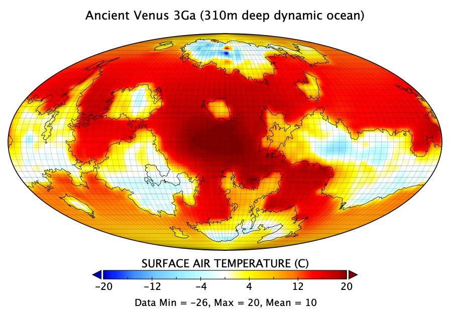
Supercomputers are like computational “time machines,” and scientists use them to explore the past, present, and future universe. Using the NASA Center for Climate Simulation’s Discover supercomputer and the ROCKE-3D computer model, scientists from NASA’s Goddard Institute for Space Studies in New York are simulating the climates of planets inside and outside our solar system. These simulations show that three billion years ago, Venus, Earth’s closest planetary neighbor, may have been temperate long enough to have an ocean – making Venus possibly the first habitable world in our solar system.
Farther from Earth, running ROCKE-3D with ocean characteristics more realistic than in previous models, scientists found that extrasolar world Proxima Centauri b is more habitable than previously believed.
Closer to home, simulations of the Moon reveal that water released by ancient volcanoes closer to the lunar equator can find its way to permanently shadowed polar regions, where we could potentially use it for future exploration.
For more information about NASA’s virtual exhibit at the International Conference for High Performance Computing, Networking, Storage and Analysis, visit:
For more information about supercomputers run by NASA’s High-End Computing Program, visit:
For news media:
Members of the news media interested in covering this topic should reach out to the NASA Ames newsroom.
Authors: Jill Dunbar, Michelle Moyer, and Katie Pitta, NASA’s Ames Research Center and Jarrett Cohen and Sean Keefe, NASA’s Goddard Space Flight Center