


Tropical rainforests are among the most biodiverse ecosystems in the world, hosting dense populations of plant and animal species found nowhere else on Earth. They also provide essential resources for people, such as freshwater, food and medicines.
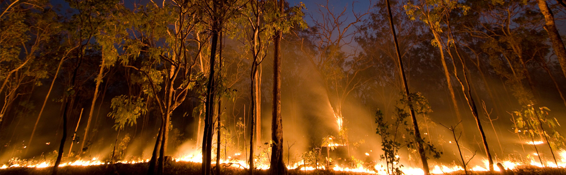
One of the greatest risks that such rainforests face is forest fires — a threat NASA is helping to keep at bay.
Conservation International, with help from NASA funding, supercomputers and satellites, has created an improved fire-detection, monitoring and risk forecasting system called Firecast. The system is one of 50 technologies benefiting the public benefiting the public highlighted in NASA’s 2017 Spinoff publication.
Among other features, the Conservation International system uses imagery from NASA satellites to spot fires across wide swaths of remote territory and to map ground cover from one year to the next to alert authorities to illegal deforestation.
Satellite data are also used to calculate factors like ocean surface temperature and moisture levels on the forest floor, which can help forecast the risk of fires starting or spreading on a given day and over the entire dry season.
Conservation International first created the separate alert and warning systems in the early 2000s under a NASA grant, but by 2012 both were in serious need of an upgrade, explains Karyn Tabor, who was principal investigator for the upgrade and who previously ran the organization’s fire-risk system. For one thing, over the decade since the systems were created, NASA had launched several new satellites, and Conservation International wanted to take advantage of the newly available imagery.
A Million Gigabytes
But creating an updated prototype required drawing from a vast trove of data collected over four decades of satellite missions dating back to 1972. All told, NASA has more than a petabyte, or a million gigabytes, of satellite imagery, and even a subset of that data required computing resources Arlington, Virginia-based Conservation International simply did not have.
That’s where NASA’s supercomputers came in, via an outreach program called NASA Earth Exchange (NEX) designed to leverage the supercomputing facility at Ames Research Center to enhance scientists’ ability to use satellite data for societal benefits. Conservation International applied and received a grant to use the supercomputer through NEX, a huge boon for the environmental group.
“The issue when you’re developing a new model or application is that you can spend months pulling together and processing all the datasets,” explains Forrest Melton, senior research scientist at California State University who became a co-investigator on the Firecast project. But NEX already had more than 800 terabytes of data that Conservation International could use to develop and prototype its new model, and the processing power to use it efficiently.
The large computing and storage space allowed the researchers to expand the forecasting model from Bolivia, where the earlier version had been used, to Colombia, Peru, Venezuela, Ecuador, Guyana, Suriname, Paraguay, Madagascar and Indonesia. Once the expanded prototype was developed and tested on NEX, it was moved to a production server on the Amazon Web Services Elastic Compute Cloud platform, a program that also shares supercomputing resources.
Global Scale, Local Impact
Now authorities in all 10 countries can receive email alerts, maps and reports whenever there’s a disturbance or encroachment to the ecosystem, information they can use to direct firefighting resources, arrest or fine lawbreakers, and inform the community about the state of the forest they live in.
In addition to the insights provided by satellites, Conservation International wanted to take advantage of all the eyes on the ground, and again, NASA was able to help. Using a crowdsourcing app originally created at NASA’s Stennis Space Center, individuals can upload reports and photos of events they see around them. So far it is only being used in Madagascar and Peru, but the organization expects that to expand with time.
Importantly, she and her team work closely with the authorities and conservation groups in each country to tailor the system to their specific needs and “so they have an invested interest in it,” Tabor says.
And the close collaboration with NASA continues: recently Tabor has forged a partnership between Conservation International and NASA’s Applied Remote Sensing Training program to build the capacity of conservationists worldwide to use Earth-observation data and tools.
“Tabor works with countries that have extremely limited access to information and data and helps them fill a critical information gap,” says Amber Soja, a scientist at NASA’s Langley Research Center and associate program manager for wildland fires and disasters under the Applied Sciences Program, who manages the partnership with Conservation International.
“Karyn’s is an international-scale project that truly serves local communities,” Soja adds.
NASA has a long history of transferring technology to the private sector. Each year, Spinoff profiles about 50 NASA technologies that have transformed into commercial products and services, demonstrating the wider benefits of America’s investment in its space program. Spinoff is a publication of the Technology Transfer Program in NASA’s Space Technology Mission Directorate.
To learn more about this NASA spinoff, read the original article from Spinoff 2017.
For more information on how NASA is bringing its technology down to Earth, visit http://technology.nasa.gov.