


NASA has for years used its cutting-edge space-based and airborne instruments to better understand hurricanes and give weather forecasters new insights they could use to improve the accuracy of their storm forecasts. A NASA program focused on bringing new weather research to bare on forecasting challenges is now tackling predictions of a hurricane’s strength.
The Short-term Prediction Research and Transition (SPoRT) team based at NASA’s Marshall Space Flight Center in Huntsville, Alabama, bridges the weather research and operational forecasting communities. SPoRT team members work closely with forecasters to understand how NASA technologies and data can help them make more accurate predictions. The process is a continual conversation between researchers and forecasters to develop, refine and use new tools and data sets.
SPoRT is working on new or better ways to incorporate existing satellite data into hurricane intensity forecasts, with the ultimate goal to provide the best information to those in the path of the storm.
“SPoRT’s goal is to help solve some of the toughest problems in the weather forecasting community using NASA tools and data,” said Christopher Hain, SPoRT project scientist at Marshall Space Flight Center. “Rapid intensification near the coast poses a very significant risk because it is difficult to forecast.”
Meteorologists and weather forecasters look for signs of rapid intensification by studying a storm’s internal structure, which can then be factored into forecast models to predict the storm’s severity. But it’s not as easy as looking at a storm’s picture.
“That’s because the forces that govern intensity are largely happening inside the storm where it’s very hard to see through a hurricane’s thick clouds and rain,” said SPoRT research scientist Patrick Duran. “But by combining satellite measurements with other data sources, we can gain a greater understanding of what’s happening within a storm.”
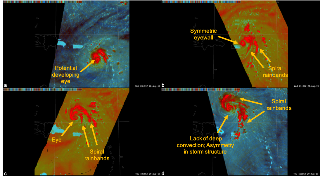
For example, SPoRT scientists and researchers have been experimenting with microwave data from the international network of satellites that complement the NASA/JAXA Global Precipitation Measurement mission. They used it to peer deep into Hurricane Dorian, monitor changes within the storm and analyze changing structures such as eyewalls and spiral rainbands.
“In the absence of aircraft directly sampling the strength of a hurricane, microwaves tell you the most about the structure and intensity,” said Hain.
Microwaves have longer wavelengths than the infrared and visible light that are commonly used to study hurricanes. The longer wavelengths allow microwaves to penetrate deep into the storms and reveal the internal dynamics that are often obscured by the cloud tops.
“With Dorian, before it started rapidly intensifying, it looked really poor structurally from infrared. When you looked at the microwave, the internal structure was actually more like what hurricane hunter aircraft were sampling when they were flying through,” said Hain.
While seeing the internal structure of a storm provides valuable data about storm intensity, its lightning does too. The Geostationary Lightning Mapper on NOAA’s GOES — Geostationary Operational Environmental Satellites — R-series satellites provides near continuous lightning data. SPoRT analyzes this data to help forecasters determine the strength of a storm.
“One of the big statstics is that 92% of storms that have lightning close to their center intensify or maintain their strength,” said Christopher Schultz, a NASA SPoRT research scientist. “When lightning is not near the core — and is way off on the periphery — it’s a sign of weakening.”
Forecasters can also analyze sea surface temperature to predict changes in a hurricane’s intensity. SPoRT produces composite maps of sea surface temperature twice daily using data from a variety of Earth-observing satellites. Hurricanes tend to intensify when they are over warm ocean surface.
To learn more about SPoRT and the many areas of research the team conducts, visit: