President Biden Lands at NASA Ames, Tours California Storm Damage
by Abigail Tabor
President Joe Biden landed aboard Air Force One at Moffett Federal Airfield on Jan. 19, near NASA’s Ames Research Center in California’s Silicon Valley, before departing to tour recent storm damage in the state. Biden was greeted by Ames’ Associate Center Director for Research and Technology, David Korsmeyer, before departing with California Governor Gavin Newsom and Senator Alex Padilla to view consequences of flooding and other storm impacts along California’s central coast.

The state has been battered by a series of winter storms that brought intense winds and rainfall. Researchers at Ames are doing their part to help by studying the source of these extreme weather events: atmospheric rivers. These narrow bands of water vapor transport in the atmosphere are often responsible for up to half the annual total precipitation over parts of the western U.S. Atmospheric rivers provide important water supply but can also cause devastating floods.
The ability to predict atmospheric rivers on the scale of two weeks to a season in advance is crucial for mitigating impacts of flooding, securing water resources, preventing wildfire events, and ultimately protecting the whole ecosystem under a warming climate. Scientists with NASA, San Jose State University, and the National Oceanic and Atmospheric Administration recently published results investigating the relationships between a climate pattern called the arctic oscillation, snowpack, and atmospheric rivers. The goal is to improve longer-term predictions of atmospheric rivers and, ultimately, water resources across the western U.S.
Employees Observe Moment of Silence During NASA Day of Remembrance Ceremony

Moon Mountain Name Honors NASA Mathematician Melba Mouton
by Rachel Hoover
Scientists recently named a mesa-like lunar mountain that towers above the landscape carved by craters near the Moon’s South Pole. This unique feature will now be referred to as “Mons Mouton,” after NASA mathematician and computer programmer Melba Roy Mouton (MOO-tawn).

Members of NASA’s Volatiles Investigating Polar Exploration Rover (VIPER) mission proposed the name to the International Astronomical Union (IAU). The flat-topped mountain is adjacent to the western rim of the Nobile Crater, on which VIPER will land and explore during its approximately 100-day mission as part of NASA’s Artemis program.
The IAU theme for naming mountains (mons) on the Moon focuses on “scientists who have made outstanding or fundamental contributions to their fields.” The lunar landmark naming honors and recognizes Mouton’s life, her accomplishments as a computer scientist, and her contributions to NASA’s missions.
“Melba Mouton was one of our pioneering leaders at NASA,” said Sandra Connelly, the acting associate administrator for science at NASA Headquarters in Washington. “She not only helped NASA take the lead in exploring the unknown in air and space, but she also charted a path for other women and people of color to pursue careers and lead cutting-edge science at NASA.”
Mouton was first employed at NASA’s Goddard Space Flight Center in Greenbelt, Maryland, in 1959, just a year after the space agency was established. She became the head mathematician who led a group of “human computers,” who tracked the Echo 1 and 2 satellites, launched into Earth’s orbit in 1960 and 1964, respectively.

A few years later, in 1961, Mouton was the head programmer responsible for the Mission and Trajectory Analysis Division’s Program Systems Branch – the team who coded computer programs used to calculate spacecraft locations and trajectories, giving NASA the ability to track spacecraft while in orbit.
Before retiring in 1973, after a career at NASA that spanned 14 years, Mouton had become the assistant chief of research programs for the Trajectory and Geodynamics Division at Goddard. In appreciation of her dedicated service and outstanding accomplishments, which culminated in the successful Apollo 11 Moon landing on July 20, 1969, she was recognized with an Apollo Achievement Award.
As NASA prepares to send astronauts to the lunar surface, including the first woman to set foot on the Moon, Mons Mouton is among one of the 13 candidate landing regions for Artemis III.
The wide, relatively flat-topped mountain, about the size of the state of Delaware, was created over billions of years by lunar impacts, which sculpted it out of its surroundings. As a result, Mons Mouton stands as tall as Denali – the tallest mountain in North America – approximately 20,000 feet higher than its neighboring features on the Moon’s South Pole. Because it is relatively untouched by bombardments, scientists believe Mons Mouton is much more ancient – possibly billions of years older than its surroundings. A ring of huge craters – evidence of its pulverizing past – lie around its base; some with cliff-like edges, descending into areas of permanent darkness. Its rolling hilltop is peppered with smaller rocks and pebbles as well as lots of enticing craters that are frequently blanketed in freezing, shifting shadows.
“Mons Mouton represents a great spot for VIPER – our solar-powered Moon rover that we’ll drive and conduct science in near real-time,” said Dr. Sarah Noble, VIPER program scientist at NASA Headquarters in Washington. “It features high sunny spots, it’s relatively flat, satellite data shows signs of water ice, and it allows long stretches of direct communications with our ground station on Earth.”
VIPER will be the first resource mapping mission beyond Earth. It will search at and below the lunar surface to determine the location and concentration of any ice could eventually be harvested to sustain human exploration on the Moon, Mars, and beyond and will help advance scientific exploration of the Moon by helping to understand how water is created and deposited throughout the solar system. VIPER is planned for delivery to the Moon in late 2024 under NASA’s Commercial Lunar Payload Services (CLPS) initiative.
In Her Own Words: How a NASA Engineer’s Journey Unfolded in Unexpected Ways
by Abigail Tabor
Carol Carroll didn’t start out with the hopes and dreams of becoming an engineer. As a child, the deputy center director of NASA’s Ames Research Center in California’s Silicon Valley didn’t know what engineering was, let alone that the career field existed, or that it was an option for her. For “Introduce a Girl to Engineering Day,” we share the inspiring story of how she became an engineer.
As a young girl, Carroll was completely fascinated with designing houses. She would take a shoe box and paste in cardboard walls, make curtains out of tissues, and hang them on the windows she cut out.
Growing up her family had a travel trailer that was roughly 17 feet long, just enough space for all five of them. It was small, and she was enamored with the tiny sink, the tiny stove, and the tiny little shower. She would take a piece of paper and redesign it all. She would imagine and create new floor plans and engineer a brand-new trailer. For Carroll, it was more than fascination, it was passion. She loved designing and figuring out different ways to do things.
Challenging Traditional Roles
Carroll’s father passed away when she was 10, and her mother, who was a nurse at the time, went back to school to become a teacher for health occupations. Having to be both a mother and a father, Carroll’s mother challenged the traditional role of a woman in that era, which profoundly impacted Carroll. She used to help her mother grade papers and learned a great deal about anatomy and physiology and developed a love for medicine.

Somewhere during her junior year of high school, because of her strong interest in design, Carroll decided she wanted to take drafting at school. At that time, girls were not allowed to – it was a class only for boys. Carroll’s mom had to go to the principal and then to the school board for approval, and Carroll became the first girl to take drafting at her high school.
As she began thinking about her career options, she considered if she should be a lawyer or a doctor. She thought, “being an architect was a natural fit,” until she realized she was not artistic. She didn’t know what other careers were out there. It was her stepfather, Del, who said, “Carol, you really should consider engineering.” And she thought, “What the heck is an engineer?”
That is how she began attending several sessions of an “Explore Engineering” program in her community, where it gave her the opportunity to meet and engage with people who were engineers – which, ultimately, led her to choosing a career in engineering.
At Virginia Tech, in Blacksburg, Virginia, she began her university studies in biomedical engineering, marrying the love she had for the medical field and engineering into one career, but she switched to mechanical engineering, which was a much better fit for her. Mechanical engineering can be applied to anything, she says, and has been a great and successful career for Carroll, giving her the opportunity to work on a wide range of projects, from rocket motors to wind tunnels to thermal protection systems.
Inspiring a New Message
However, engineering wasn’t always a clear path in front of her. In fact, in high school, she took an aptitude test and was told that she should be a social worker or a nurse. Not an engineer.
How many girls today who can be successful engineers are hearing that same message? In Carroll’s college engineering classes, only about 10 percent of students were women, and today women are still underrepresented in the engineering field.
Carroll’s own journey to an engineering career unfolded in unexpected ways. It was her stepfather who introduced her to engineering and her mother, a trailblazer, who told her that she could do anything she aspired to do. By encouraging her not to take “no” for an answer, she helped put Carroll on her path to becoming an engineer.
At NASA, we celebrate “Introduce a Girl to Engineering Day” to share the exciting and diverse field of engineering with the young women and girls in our lives and across the world, and with those who may not have an engineering role model. We encourage them to explore the world of engineering as a potential career field.
Join us in this initiative and be the person who introduces engineering to the next generation of women engineers. Be the voice that inspires and tells them that they can do anything. They can be the future of engineering.
NASA’s Autonomous Aircraft Decision Tech Gets Simulated Urban Test
by Abigail Tabor
Cities are complicated places to fly. Tall buildings, local microclimates, high winds, and other factors present challenges – both known and unpredictable – for current and future air vehicles. But creating new air mobility solutions to move people and cargo will require addressing those challenges. And that’s where NASA’s Data & Reasoning Fabric (DRF) project can help.
DRF designs technology to help autonomous airborne activities safely meet their full potential for society’s benefit. Its intent is to form a connected, interwoven “fabric” of intelligence that sends aircraft specific, tailored information, wherever they are.
Reducing airspace congestion to increase safety in cities while connecting people and services are the kinds of considerations driving the DRF team. And so, in February and March, the team is performing the first test of its technology in a simulated urban area, one modeled on the Phoenix metropolitan area.
The DRF technology helps assemble diverse sets of data from various providers, as well as reasoning services powered by artificial intelligence, to make sense of the complex and dynamic airspace.
A familiar reasoning service is the navigation app many people have on their phone. Different kinds of data – maps, accident reports, traffic conditions – are drawn in by the app, which sorts through it all and tells the driver the best route to take at the time.
Decisions needed by autonomous aircraft of the future could be made in a similar way. And the web, or “fabric,” of intelligence enabled by DRF will provide critical information to operators and autonomous aircraft, wherever they are, to make decisions in time.

Data and Decision-Making
In early February, NASA, along with its partners, began field trials for the current prototype system. This partnership group included Autonomy Association International of Mountain View, California, as well as members from academia, industry, government, communities, tribal nations, and more than 22 cities across Arizona’s Maricopa, Pinal, Pima, and Yuma Counties.
“This activity can help providers of data and decision-support services better understand the needs of future airspace users and the benefits of DRF,” said Kenneth Freeman, DRF’s principal investigator at NASA’s Ames Research Center in California’s Silicon Valley. “Users are able to compare multiple services to select the one that fits their needs: weather data from this source, air traffic updates from another. With further development, we expect this model to potentially drive innovation in the industry, which could lead to improvements in the quality of airspace services.”
The Phoenix test looks at specific scenarios where DRF could be useful, studying them in the context of a simulated drone flight to deliver medical equipment and supplies from downtown Phoenix to the outermost areas of the greater region.
Future scenarios might involve insulin delivery for people in locations with limited access to health care services or re-routing an air taxi around a sudden dust storm.
The test participants are working within the digital ecosystem enabled by DRF, assessing their ability to select data and reasoning services that support safe and autonomous flight.
DRF’s potential to accelerate airborne emergency response was illustrated in a previous test with the California wing of the Civil Air Patrol. Using simulated drone flights, the DRF technology helped locate lightning-induced wildfires more quickly than usual.
Agile Responses to Anomalies
When something unexpected occurs in a flight path, such as a storm, the announcement of a no-fly zone, or a drop in communication coverage, safety depends on the ability to make critical choices at a moment’s notice.
DRF’s current field test studies how well its system can support rerouting an aircraft due to several different anomalies: communication disruptions – for instance, between the aircraft and weather sensors, navigation aids, or ground control – an unidentified or unexpected drone in the flight path, and sudden changes in local weather conditions.
In such scenarios, DRF technology is designed to alert an aircraft approaching one of these anomalies and connect them to services that can provide more information and guidance to respond with agility.
To accomplish its goals, DRF uses edge computing, a system where data is handled, processed, and stored locally – at the “edge” of the network – rather than being sent to a cloud or a data center. This reduces the delays associated with transmitting large sets of data and allows for faster decision-making in time-sensitive situations.
A Future of Advanced Air Mobility
Across NASA, researchers are conducting Advanced Air Mobility studies that will transform U.S. communities, creating new ways to move people and goods in the sky. The data and AI-based decision-support tools enabled by the DRF concept will help further the AAM community’s goals by providing information needed for future flight operations.
This air transportation system of the future will include low-altitude passenger travel options, cargo delivery, and public service capabilities. NASA is delivering data that guides industry’s development of electric air taxis and drones and assists the Federal Aviation Administration’s safe integration of such vehicles into the national airspace.
Today, the DRF team is looking ahead for needs that can be addressed with autonomous flights supported by their digital ecosystem, helping enable the future of air mobility.
DRF is an exploratory activity under the Convergent Aeronautics Solutions project, which is designed to give NASA researchers the resources and pathways they need to determine whether their ideas to solve some of aviation’s biggest technical challenges are feasible and potentially worthy of additional pursuit within NASA or by industry.
NASA Machine Learning Air Traffic Software Saves Fuel
by Hillary Smith
A NASA air traffic management planning tool has saved more than 24,000 pounds of jet fuel and prevented the release of more than 77,000 pounds of carbon dioxide emissions into the atmosphere since it was implemented at the Dallas-Fort Worth International Airport (DFW) in January 2022. By using machine learning to predict traffic conditions based on real-time data, the tool could improve air traffic operations in major airports across the country in the future.
NASA’s Digital Information Platform (DIP) project partnered with Southwest Airlines, American Airlines and the Federal Aviation Administration (FAA) to begin testing the Collaborative Digital Departure Reroute (CDDR) tool earlier this year. CDDR improves current air traffic operations at commercial airports by integrating air traffic data from the FAA and surface traffic data from the airlines and applying machine learning to provide traffic predictions about future runway availability and estimated departure and arrival times. Airline operators use these predictions to schedule the optimum time an airplane should takeoff to make a seamless entrance into the overhead stream of traffic. This reduces the time planes spend idling on the runway, as well as fuel use and emissions.
American and Southwest flight coordinators have since used CDDR’s traffic predictions to identify alternate takeoff routes to avoid delays during periods of high traffic when airspace constraints limit the capacity and need to balance the excess demand. This has improved air traffic management operations, reduced delays, and saved fuel.
NASA leadership recently visited the airlines’ operation centers near DFW to see the air traffic management planning tools in action.
“This planning tool utilizes the cutting-edge capability of machine learning to transform air traffic management and significantly reduce carbon emissions at major airports and other locations throughout the country,” said Bob Pearce, associate administrator for NASA’s Aeronautics Research Mission Directorate. “Demonstrating CDDR in real airport traffic operations is an important step toward making air travel more efficient and environmentally sustainable for the info-centric airspace of the future.”
Over the past year, NASA engineers have analyzed the CDDR tool’s ability to use machine learning to accurately predict traffic conditions based on historical and real-time traffic data at DFW. Particularly, engineers were interested in the tool’s ability to accurately predict traffic conditions during months with heavy rain, which are often accompanied by an increase in traffic backups. The team evaluated CDDR’s performance by analyzing and comparing the number of reroutes identified by the tool, the number of reroutes requested by operators, how many requests were ultimately approved, and how much jet fuel was saved as a result. The tool’s machine-learning-based predictions were slightly better than previous predictions, according to project engineers.
Improving and expanding the use of this machine-learning capability is an important milestone for the project. It means the tool could be more easily adopted at other airports across the country.
“Reusability of a service is a big deal,” said Mirna Johnson, DIP project manager. “Because each airport surface is unique, it is very difficult to create a solution for one airport that will work for another. Machine learning allows us to use the same machine-learning models for multiple airports.”
This year, NASA engineers will test a cloud-computing-based version of the system at DFW. Then the DIP project team will test the system’s adaptability by implementing it at different locations across the country. The goal is to validate the tool so it can be implemented and provide benefit at major airports throughout the country. This effort directly supports NASA’s contributions to the United States’ aviation goal of reaching net zero carbon emissions by 2050.
CDDR builds on the capabilities and benefits of a similar tool implemented under NASA’s Air Traffic Demonstration 2 (ATD-2) project at Charlotte Douglas International Airport (CLT). The tool demonstration at CLT saved more than one million gallons of jet fuel, 23.2 million pounds of emissions, and more than 6,000 hours of engine run time between September 2017 and September 2021. DIP’s CDDR tool goes one step beyond the ATD-2 single airspace tool because it’s designed to be adaptable and scalable for use in many airspaces by many different users, including passenger and cargo flight operators and cargo carriers.
DIP is a subproject of NASA’s Air Traffic Management (ATM-X) project and is led out of NASA’s Ames Research Center in California’s Silicon Valley.
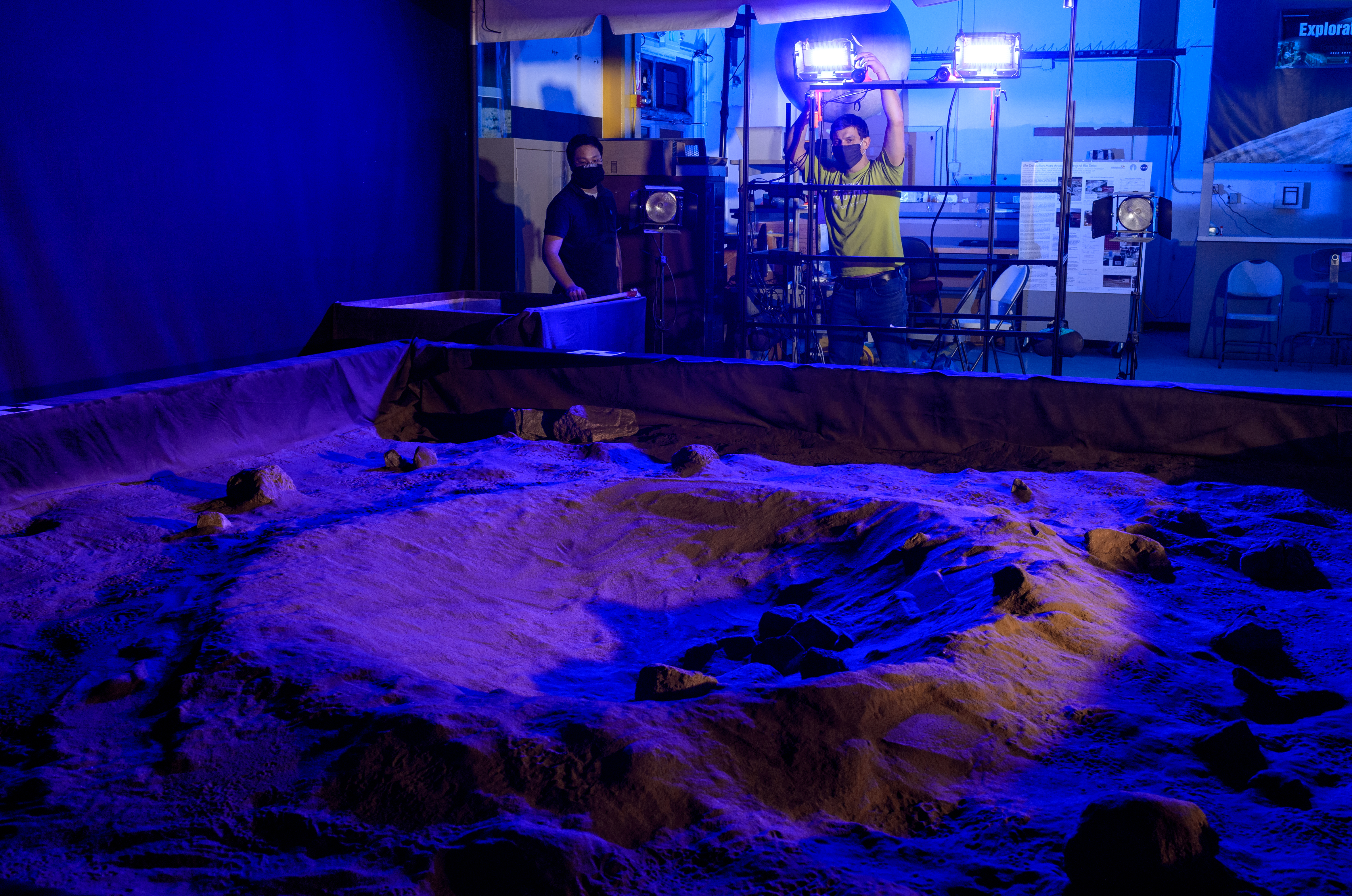
The Lunar Lab and Regolith Testbeds
A lab with ultra-realistic lighting conditions and terrain features for recreating the two major types of lunar surfaces that future robots, rovers, and astronauts will experience in the Moon’s polar regions.
The polar regions of the Moon are very different from the terrain Apollo astronauts experienced. When rovers and astronauts carry out missions at the lunar South Pole, they’ll have to navigate in low-angle lighting and overcome harsh solar glare that makes it difficult to see. Because the Sun will never rise overhead, even the smallest rock or crater will cast long shadows and cloak craters in darkness. And, at times, the Sun will blaze at eye-level as it reflects off the soil.
Future human and robotic explorers of off-planet polar regions also will need to contend with the incredibly abrasive and “sticky” lunar dust, known as regolith. Moon dust has grains as fine as powder, as sharp as tiny shards of glass, and a curious capacity to electrostatically cling to everything, due to the way it was formed. Add in the lack of an atmosphere and the fact that the Moon is home to some of the coldest places in our solar system, and the lunar environment will pose a challenge to machinery and spacesuits, at best. At worst, it could be a hazard.
For years, research scientists and engineers from NASA and industry alike have used the Lunar Lab and Regolith Testbed at NASA’s Ames Research Center in California’s Silicon Valley to study how well science instruments, robots, and people might be able to safely work, manipulate, navigate, and traverse the tough lunar terrain. The Testbed also enables research applicable to places beyond our Moon, including Mercury, asteroids, and regolith-covered moons like Mars’ Phobos.
Ames’ Role
The Lunar Lab and Regolith Testbed currently houses two large indoor “sandboxes” filled with tons of simulated lunar dust. With both testbeds, most areas on the Moon can be simulated with a high degree of accuracy.

The facility’s first sandbox measures approximately 13 feet by 13 feet by 1.5 feet (4 meters by 4 meters by 0.5 meter) and is filled with eight tons of Johnson Space Center One simulant (JSC-1A) – making it the world’s largest collection of the material. The JSC-1A simulant mimics the Moon’s mare basins and is dark grey in color.
The facility was recently upgraded to include a second, larger testbed, filled with more than 20 tons of Lunar Highlands Simulant-1 (LHS-1), which is light grey to simulate the lunar highlands. It measures 62 feet by 13 feet by 1 foot (19 meters by 4 meters by 0.3 meter), and can be reconfigured to be a smaller, but deeper, testbed.
Sometimes researchers painstakingly shape the dust with hand tools to recreate, as accurately as possible, features astronauts and rovers are likely to encounter. These include tiny pits and small craters measuring as small as a couple feet to a few yards across. It may also mean placing small rocks and other debris to resemble actual places observed by Moon-orbiting spacecraft.
One feature that makes the Testbed truly unique, is a set of bright, high-power lights that simulate the Sun’s glaring rays as they are cast across the lunar landscape. Researchers can accurately recreate lighting conditions that are relevant to locations on the Moon’s poles and across a range of lunar times – past, present, or future.
Established in 2009 by NASA’s Centennial Challenges Program as the Lunar Regolith Testbed in the NASA Research Park at Ames, the facility was created through a partnership between the then-called NASA Lunar Science Institute (now the agency’s Solar System Exploration Research Virtual Institute) and the California Space Authority. Since then, it’s been used year-round by researchers seeking a high-fidelity environment to test hardware designs intended for the lunar surface, including projects within the agency’s Advanced Exploration Systems and Game Changing Development technology programs.
The Volatiles Investigating Polar Exploration Rover (VIPER)
NASA’s new Moon rover, the Volatiles Investigating Polar Exploration Rover (VIPER) team uses the Regolith Testbed to test how well the rover’s lighting systems and hazard avoidance cameras handle the very low-angle illumination it will experience while mapping the Moon’s South Pole.
In the extremes of light and dark found on the Moon, shadowed and lit areas are in such high contrast that any contours in the landscape are effectively invisible in the darkness. To navigate this world, VIPER’s rover drivers will rely on a system of rover-mounted lights and cameras to steer clear of boulders, descend steep declines into craters, and avoid other potentially mission-fatal dangers.
As it journeys into some of the darkest and coldest spots in the solar system, VIPER will use a set of very robust headlights to light the way. And to make sure the first-ever lighting system on a rover will reveal obstacles hiding in the shadows, the VIPER team tested prototypes in the high-fidelity recreation of a lunar landscape at the Regolith Testbed at NASA Ames, where the mission is led.
Artemis Missions
With NASA’s Artemis missions, the agency will land the first woman and first person of color on the Moon. When these astronauts take their first steps, it’ll likely be near the Moon’s South Pole: a land nobody has ever seen in person, and a place that’s known for its extreme light and darkness.
Among the many things NASA must take into account when choosing a landing location is the sunlight conditions. Sunlight is a valuable resource that could power equipment but also pose a disadvantage when it produces long shadows where hazards could hide.
To mimic how human eyes perceive depth, researchers set up two cameras, called a stereo imaging pair, over a simulated lunar polar terrain in the Regolith Testbed. The team then captured thousands of photographs of multiple landscape setups and low-lighting angles to create a dataset that could be used to inform future robotic and crewed missions.
Intelligent Systems Research
Since 2016, Ames’ Intelligent Systems Division (ISD) has been the primary research tenant in the Regolith Testbed. In addition to developing the navigation system for the VIPER mission, ISD conducts cutting-edge research into robotics, autonomy, and sensing in the facility. The testbeds have been used to develop novel mobility systems and as proving grounds for new types of LIDAR, visual odometry, virtual bumper, and microscopy sensing. Facility upgrades and precision ground truthing equipment ensure that the testbed is an ideal location for building and testing intelligent systems destined for the Moon.
Statistical Summary of Activities of the Protective Service Division’s Security/Law Enforcement and Fire Protection Services Units for Period Ending January 2023