


![Request for Information – Potential [Placeholder for Prize]](https://assets.science.nasa.gov/dynamicimage/assets/science/psd/solar/2023/09/s/solarsystem_0.jpg?w=1024)


Creating a low-cost, high-value air quality network across California with INSTEP
As we head into the beginning of August, California’s fire season is showing no signs of slowing down. California has gone months without rain, and warmer weather has left vegetation bone-dry. These fires that erupt tend to burn hotter and faster, with extreme fires becoming a growing threat to public health and safety – not to mention to older forests, homes, and surrounding air quality. Scientists are leading an effort to measure how it affects air quality (AQ) and pollution.
According to the Environmental Protection Agency, wildfires “increase air pollution in surrounding areas and can affect regional air quality.” The effects of smoke can be wide ranging – from eye and respiratory tract irritation to more serious disorders. Unfortunately, larger AQ equipment can be expensive and bulky, making it difficult to measure in a range of different locations and risking equipment damage when too close to the very fires they are trying to measure.
Kristen Okorn is hoping to change that. Okorn, a NASA Postdoctoral Program Fellow at the NASA Ames Research Center, is studying air quality and atmospheric chemistry. This summer, she launched a new inexpensive air pollution sensing network – INSTEP – but also informally called the “lunch box.” The idea is to help drive air quality equipment costs down.
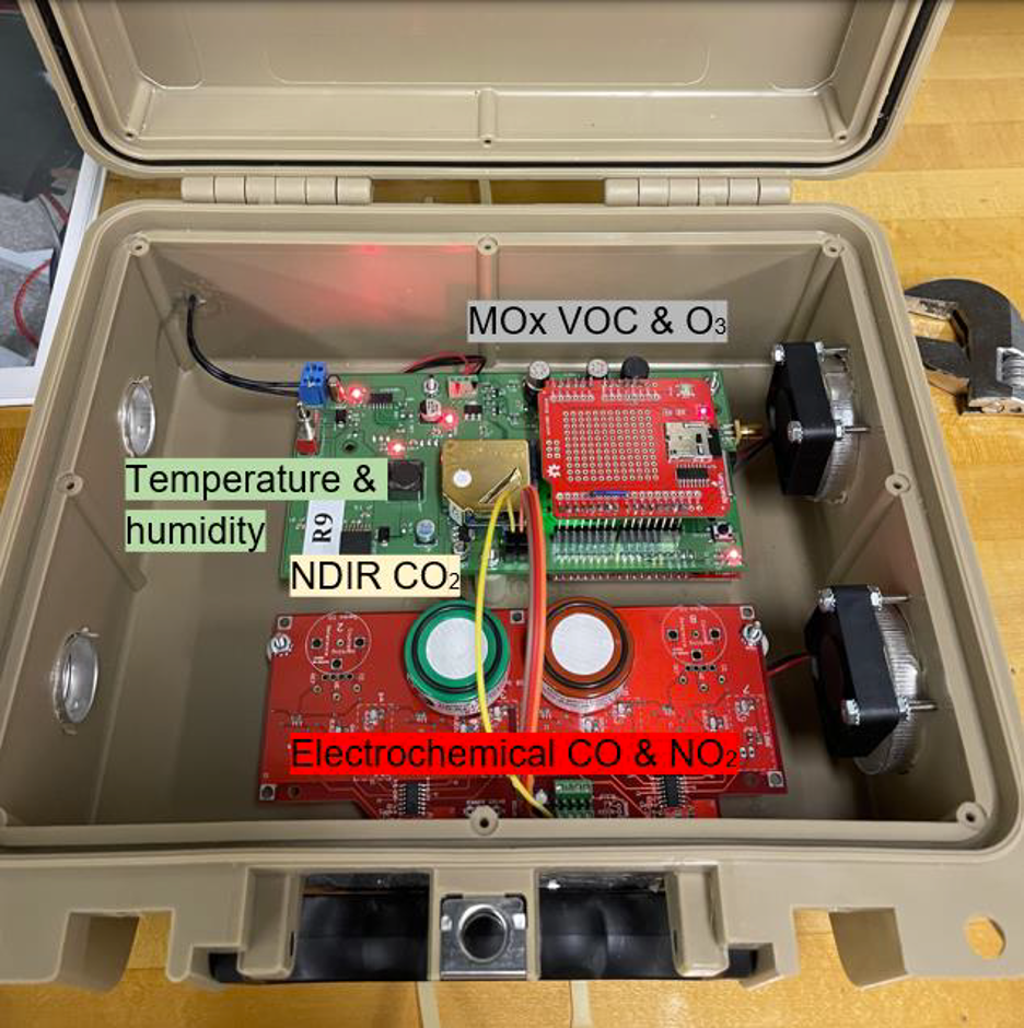
INSTEP stands for ‘Inexpensive Network Sensor Technology for Exploring Pollution’. “It’s a compact, inexpensive way to house sensors measuring a variety of pollutants,” describes Okorn. Each monitor costs approximately $1,000.
“The highest quality pollutant-measuring instruments may cost tens of thousands of dollars, and with one instrument, you can only measure in one location,” explains Okorn. “With INSTEP, we can build tens of them with that same budget, and be able to collect data in multiple locations.”
The team plans to capture a year’s worth of in situ surface trace gas data to compare with the column measurements that will be supporting satellite validation. The boxes pack a nice punch, measuring carbon monoxide (CO), carbon dioxide (CO2), nitrogen dioxide (NO2), ozone, methane, formaldehyde, temperature and humidity. It is powered using a simple 120V power outlet, no different than certain electrical outlets in the average home.
History and Installation
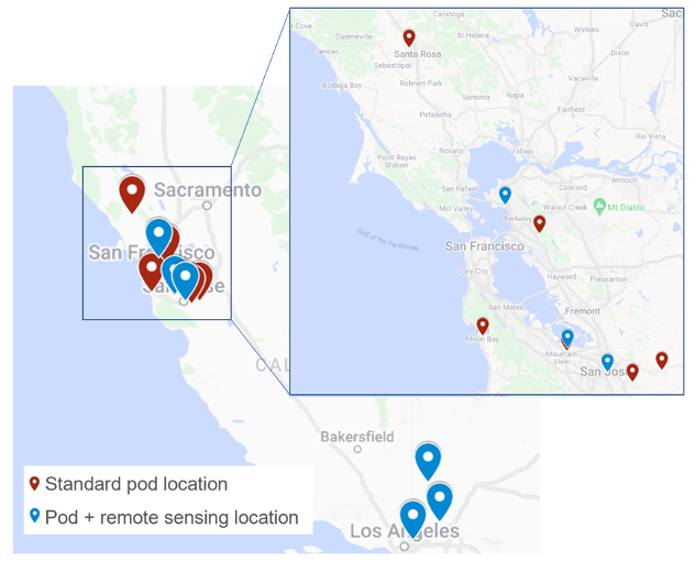
INSTEP started a decade ago at the Hannigan Lab at CU Boulder, and has evolved to include more pollutants and measurement locations worldwide. NASA Ames is deploying 12 of these this summer: nine in Northern California in the San Francisco Bay Area, and three in Southern California within 70 miles of Los Angeles. Some are installed where existing measurement tools are already in place, including the NASA Armstrong Flight Research Center. The site now includes the TCCON, Pandora, and INSTEP measurement instruments.
“The initial science plan is to leave them out through the end of October to capture the typical fire season. Beyond that, if all is going to plan we will leave them in place and extend the science mission until the following summer to capture data from any additional fires, and have data outside of the prescribed fire season to compare with,” said Okorn.
“So far, the data from the monitors we have up and running looks really good, so that has been exciting,” said Okorn. “We’re as ready as we can be for fire season.”
Data is captured on a memory stick that is retrieved manually once every few weeks. “Luckily, we have some great partners at each of our deployment sites, many of whom are willing to help with data retrievals. It’s old-school, but the benefit of this is that we don’t have to worry about WiFi dropping in and out, which can cause data loss.”
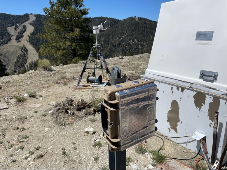
“The placement comes down to three things: One, where we can get good airflow into the device. Two, where can we get to an outlet and three, making sure it’s out of the way so people or animals won’t tamper with it.”
Placement in the field
Before deploying the sensors, they need to be “calibrated”, which involves placing them next to more expensive, more reliable air quality instruments for a period of about two weeks. Okorn then uses machine learning to get the low-cost sensor signals to match that of the higher quality instruments. Once this process is complete, the sensors are ready to be put out into the field.
So why place the INSTEP monitors next to pre-existing air quality instruments? The lunchboxes may be able to provide a different view on the same air. “The other air quality instruments are remote sensing, which look at a column of air from the ground all the way up into the atmosphere,” Okorn explains. “The INSTEP monitors are all placed around ‘human height’ – anywhere from 6 to 20 feet off the ground. These might better represent the pollution that humans are breathing in.” This comparison between different types of air quality monitors is crucial to the team’s scientific mission.
Democratizing Air Quality Sensors
Working with the established atmospheric team at NASA has been a boon, says Okorn. “This project has been a perfect combination of my research strengths, namely working with the sensors, combined with the remote sensing at NASA that I’m now able to learn more about [as an NPP]. Figuring out how to leverage these together has given me a lot of room to grow.”
“Our next step will be to outfit them on uncrewed aerial vehicles for wildfire sensing – flying drones into and around smoke plumes to capture emissions data,” says Okorn. “But, we need to enhance the current INSTEP version a bit before that happens. It would need to be smaller, lighter, and include telemetry. This would be a safe and inexpensive way to further study wildfires.”
The INSTEP monitors have previously been used in community-based research efforts, bringing data to areas lacking air quality monitoring. In addition to these monitors being more affordable to communities, another plus is the ease of use. “We’ve used these for K-12 education outreach and community outreach quite a bit,” Okorn adds. “They’re very simple to use and troubleshoot if anything goes wrong, making it feel accessible to anyone. We’ve had everyone from kids to grandparents be able to find their way around one.”
On expanding the network, “I see no reason not to put them everywhere!” she laughs. “The biggest thing that keeps coming up is that we don’t have enough of them – especially in underserved communities.” In addition to Okorn’s sensors in California, other researchers are currently using the monitors in Colorado and Mongolia.
Aside from the scientific impacts of this research, Okorn believes that the most rewarding aspect has been community engagement. “The connection and environmental piece is very important to me,” Okorn reflects. “I want to empower all communities and arm them with good air quality data. If we can give more information to people affected by wildfires this season, they can make better-informed decisions on how to mitigate risk and protect their health.”
